A distributed pseudolite/gnss optimal positioning method

A positioning method and pseudolite technology, which is applied in the field of distributed pseudolite/GNSS optimal positioning, can solve the problems of pseudolite pseudo-range multi-path, ambiguity fixed failure, high-precision time synchronization processing methods and other complex problems

Active Publication Date: 2020-10-16
NO 54 INST OF CHINA ELECTRONICS SCI & TECH GRP
View PDF9 Cites 0 Cited by
  • Summary
  • Abstract
  • Description
  • Claims
  • Application Information

AI Technical Summary

Problems solved by technology

However, the current distributed pseudolite high-precision time synchronization processing method is complex and difficult to operate. At the same time, the pseudolite itself has serious pseudo-range multipath problems, which affect its own performance.
In addition, when dealing with the problem of frequent ups and downs of GNSS under complex environmental conditions, the previous ambiguity fixation method will introduce the frequent ups and downs of satellites into the ambiguity fixation, resulting in the failure of the overall ambiguity fixation and the poor positioning effect

Method used


Image

  • A distributed pseudolite/gnss optimal positioning method
  • A distributed pseudolite/gnss optimal positioning method
  • A distributed pseudolite/gnss optimal positioning method

Examples


Embodiment Construction

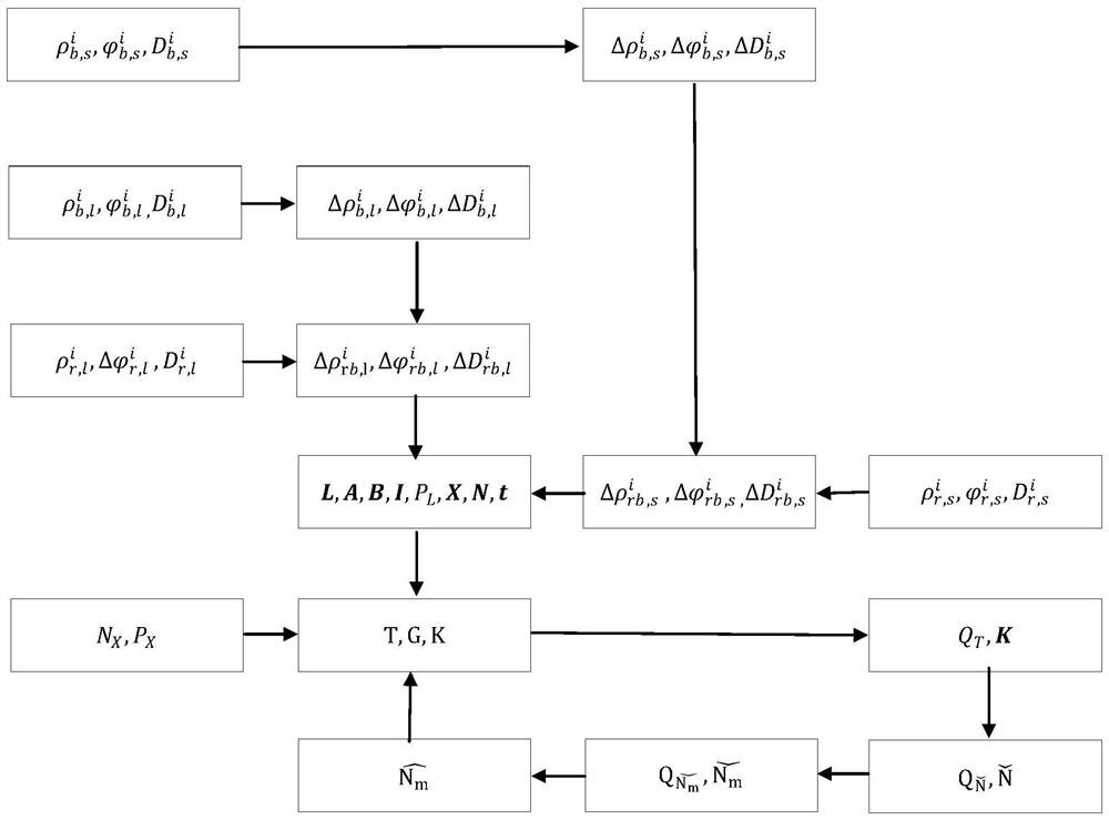
[0092] The present invention will be further described below in conjunction with the accompanying drawings and specific embodiments.

[0093] Such as figure 1 As shown, a distributed pseudolite / GNSS optimal positioning method includes the following steps:

[0094] 1. The reference station tracks GNSS / pseudo-satellites in real time and generates pseudo-range, carrier phase and Doppler observations, corrects system errors such as station-to-satellite geometric distance, ionosphere and troposphere based on the precise position of the reference station, and obtains GNSS / pseudo-satellite pseudo-satellites Distance, carrier phase and Doppler differential corrections are sent to subscriber stations based on the network. The specific way is:

[0095] ① The calculation process of GNSS pseudorange, carrier phase and Doppler differential correction at the reference station is as follows

[0096] Suppose the GNSS pseudorange, carrier phase and Doppler measurement equations of the refer...


PUM


Abstract

The invention discloses a distributed pseudo satellite / GNSS optimized positioning method, and relates to the technical field of navigation positioning. A differential information correction method constrained by a reference station coordinate is used for solving the problem of high precision time synchronization of a pseudo satellite; an optimized fuzzy fixing method combining the pseudo satellitewith GNSS is adopted to solve the problem that the pseudo satellite pseudorange multi-path constantly needs known point initialization or positioning is failed due to insufficient GNSS satellite observation; a delay ambiguity fixing method is used for solving the adverse effect on positioning accuracy caused by frequency lifting of the GNSS / pseudo satellite. The method provided by the invention has the important engineering practice application value, and improves the usability and reliability of high precision positioning under the complex environment.

Description

technical field [0001] The invention relates to the technical field of navigation and positioning, in particular to a distributed pseudolite / GNSS optimal positioning method. Background technique [0002] At present, the GNSS high-precision positioning method based on precise single-point positioning and real-time dynamic positioning plays an important role in the fields of surveying and mapping, precision agriculture, ocean exploration, aircraft precision asymptotics, etc., which greatly improves the operation mode of the industry. However, in complex environments such as urban canyons, trees, and horizontal billboards, GNSS signals are blocked, resulting in frequent ups and downs of GNSS satellites within the user's visible range and even insufficient visible GNSS satellites. At this time, GNSS-based high-precision positioning faces fatal problems in terms of usability and robustness. [0003] As an effective auxiliary system of GNSS positioning system, distributed pseudol...

Claims


Application Information

Patent Timeline
Patent Type & Authority Patents(China)
IPC IPC(8): G01S19/42G01S19/44G01S19/41
CPCG01S19/41G01S19/42G01S19/44
Inventor 盛传贞蔚保国甘兴利张京奎张衡陈秀德郑志全郭晓松
Owner NO 54 INST OF CHINA ELECTRONICS SCI & TECH GRP
Why Eureka
Try Eureka