Map drawing method based on remote sensing image tile data

A remote sensing image and map drawing technology, applied in the field of remote sensing and geographic information systems, can solve problems such as poor applicability and unification of different application systems, and achieve the effects of ensuring reliable operation, flexible storage methods, and reducing tile refresh delays.

Active Publication Date: 2019-07-26
NO 27 RES INST CHINA ELECTRONICS TECH GRP
View PDF2 Cites 15 Cited by
  • Summary
  • Abstract
  • Description
  • Claims
  • Application Information

AI Technical Summary

Problems solved by technology

The Google Maps data server can not only provide spatial data services for Google Maps clients, but also support the request for satellite image data in user-developed applications, but currently the remote sensing satellite image tile data download applicati

Method used


Image

  • Map drawing method based on remote sensing image tile data
  • Map drawing method based on remote sensing image tile data
  • Map drawing method based on remote sensing image tile data

Examples


Embodiment 1

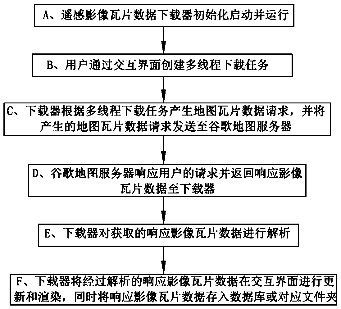
[0055] This embodiment includes the following steps:

[0056] A. The remote sensing image tile data downloader initializes and runs.

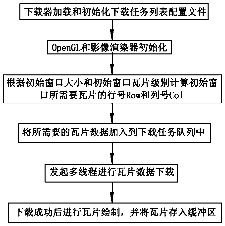
[0057] When the Google Maps satellite image downloader starts, the program will perform initialization operations. At this time, the initial display window of the interactive interface needs to download tile data and receipt. First, load and initialize the download task list configuration file, and then openGL and image renderer Initialize, specifically: when the window is initialized and updated, it will complete the initialization of the OpenGL vertex shader and fragment shader, and at the same time construct an image tile rendering class object, create and start the download task system object inside it, download the task system object and create it again And start the specified number of image tile download worker threads.

[0058] When initialization is up and running, a download task window is created and displayed, such as figure 2 As...

Embodiment 2

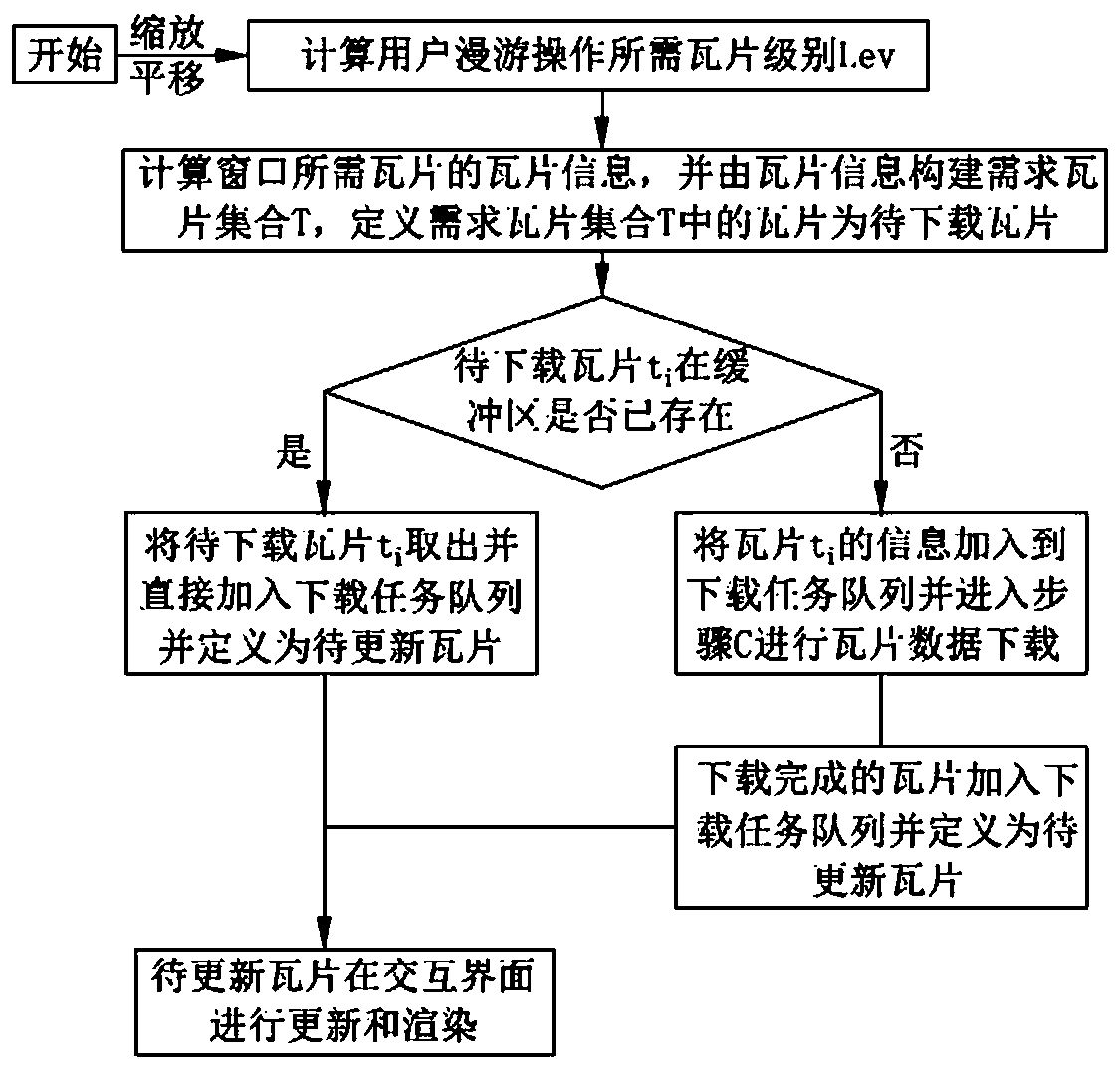
[0121] The difference between this embodiment and Embodiment 1 is that the operation type of the multi-threaded download task in step B is to create a new download task.

[0122] The specific process is:

[0123] A. The remote sensing image tile data downloader initializes and runs;

[0124] B. The user uses the producer-consumer parallel working mode to create a new download task through the interactive interface.

[0125] Such as Figure 4 As shown, the specific process is:

[0126] b2.1: Production task creation: Create a download task as a producer and initialize the tile database SQLite.

[0127] b2.2: Start the task producer thread: Calculate the tile information of the tiles to be downloaded in each level of Lev, and add the tile information to the download task list; the tile information includes the tile level Lev, the tile row number Row, and the tile Chip column number Col.

[0128] b2.3: ​​Start the consumer thread, start the download task system, then start t...


PUM


Abstract

The invention discloses a map drawing method based on remote sensing image tile data. The map drawing method sequentially comprises the following steps: initializing and operating a downloader, creating a multi-thread downloading task, generating a map tile data request, returning response image tile data, analyzing the response image tile data, and updating and rendering the response image tile data on an interactive interface. The technical route is simple and easy to implement; efficient and reliable downloading, rendering and storage of the Google map satellite image data can be realized;the requirements of various WebGIS applications on tile data can also be met; meanwhile, the tiles existing in the buffer area are not downloaded repeatedly any more; the network transmission pressureand the tile refreshing delay are greatly reduced, the calculation amount of the downloader is reduced, the downloading speed and the downloading accuracy are improved, and by adopting the two accessmodes of database storage and directory storage, the storage mode is flexible, and various requirements of users are met.

Description

technical field [0001] The invention relates to the technical field of remote sensing and geographic information systems, in particular to a map drawing method based on remote sensing image tile data. Background technique [0002] With the development of high-resolution remote sensing technology, the amount of spatial data is increasing at an alarming rate, and has the typical characteristics of multi-source and heterogeneous. Massive spatial data has greatly promoted the development of the geospatial information industry and location services, making related applications bid farewell to the status quo of "cooking without rice". [0003] Google Maps is a service software based on B / S architecture launched by Google in 2006 that can search and browse maps on a web browser. It uses the same satellite image data source as Google Earth. Google Maps map data can be divided into two types: vector map (Map) and satellite image (Satellite). In addition, a type of data called Terra...

Claims


Application Information

Patent Timeline
IPC IPC(8): G06F16/29G06F16/955G06T17/00H04L29/08
CPCG06F16/29G06F16/955G06T17/00H04L67/06
Inventor 段云龙常鹏飞张岭军李春晓张明
Owner NO 27 RES INST CHINA ELECTRONICS TECH GRP
Why Eureka
Try Eureka