Bumpy platform SAR rapid time domain imaging method based on mixed coordinate system

A hybrid coordinate system, time-domain imaging technology, applied in the field of SAR imaging processing of turbulent platforms, can solve the problems of poor side lobe integral side lobe performance, affecting image quality, and increasing the amount of calculation, so as to reduce interpolation errors and improve execution. Efficiency, the effect of improving image quality

Active Publication Date: 2019-08-06
XIDIAN UNIV
View PDF11 Cites 11 Cited by
  • Summary
  • Abstract
  • Description
  • Claims
  • Application Information

AI Technical Summary

Problems solved by technology

[0004]However, the FBP algorithm and FFBP algorithm polar coordinate sub-aperture image recursive fusion and the two-dimensional interpolation in the process of converting polar coordinates to Cartesian coordinates occupy a large part in the implementation process The specific gravity will inevitably increase the amount of calculation, and at the same time introduce interpolation errors, which will eventually affect the image quality, resulting in sidelobe elevation and integral sidelobe ratio performance deterioration, and there are certain limitations in practical applications

Method used


Image

  • Bumpy platform SAR rapid time domain imaging method based on mixed coordinate system
  • Bumpy platform SAR rapid time domain imaging method based on mixed coordinate system
  • Bumpy platform SAR rapid time domain imaging method based on mixed coordinate system

Examples


Embodiment Construction

[0022] The embodiments and effects of the present invention will be further described in detail below in conjunction with the accompanying drawings.

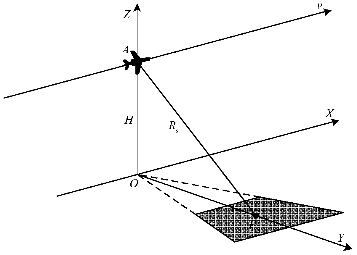
[0023] refer to image 3 As shown, it is a schematic diagram of the SAR imaging geometric model of the turbulent platform under the mixed coordinate system of the present invention; the UAV-borne synthetic aperture radar works in the strip mode, and the carrier aircraft flies along the x direction (the azimuth direction of the radar) at a horizontal velocity v, P A point is a certain pixel in the scene. The flight height of the carrier aircraft is H, and the slant distance from the scene center is R s .

[0024] refer to Figure 4 , is the flow chart of the method for fast time-domain imaging of the bumpy platform SAR based on the hybrid coordinate system in the present invention. The specific implementation steps of this method are as follows:

[0025] Step 1, use the bumpy platform SAR to transmit and receive the echo sig...


PUM


Abstract

The invention discloses a bumpy platform SAR rapid time domain imaging method based on a mixed coordinate system. The method comprises the following steps of carrying out distance direction matching filtering processing on a baseband echo signal to obtain a distance-compressed signal; dividing a subaperture to construct a mixed coordinate system imaging grid; carrying out backward projection on each subaperture data on the mixed coordinate system imaging grid; and carrying out a rapid backward projection or rapid decomposition backward projection algorithm in the mixed coordinate system on a sub-aperture image in the mixed coordinate system to obtain an SAR image with a full spatial resolution. In the invention, a polar coordinate subaperture imaging grid in a rapid time domain algorithm is replaced with a mixed coordinate grid, a two-dimensional interpolation in the time domain imaging algorithm is optimized, execution efficiency of the time domain algorithm is improved, and a processing speed and imaging quality of the time domain algorithm are increased and improved.

Description

technical field [0001] The invention belongs to the technical field of SAR imaging, in particular to a fast time-domain imaging method for SAR on a bumpy platform based on a mixed coordinate system, which can be used for SAR imaging processing of bumpy platforms such as unmanned aerial vehicles. Background technique [0002] Synthetic Aperture Radar (SAR), as an active microwave active sensor, can obtain two-dimensional images of the observation scene all-time, all-weather, and long-distance, and has been widely used in various radar carriers. SAR imaging algorithms are mainly divided into two categories: frequency domain algorithms and time domain algorithms. Since the time-domain algorithm has no restrictions on imaging conditions and does not require pulse accumulation during the imaging process, it has gradually become a research hotspot in recent years. However, the computational complexity of time-domain imaging algorithm is relatively high, which leads to certain lim...

Claims


Application Information

Patent Timeline
Patent Type & Authority Applications(China)
IPC IPC(8): G01S13/90G01S7/41
CPCG01S13/9017G01S7/418
Inventor 梁毅李国霏邢孟道王虹现
Owner XIDIAN UNIV
Why Eureka
Try Eureka