
Space-time information cloud collaborative real-time online investigation system

A survey system, space-time technology, applied in geographic information database, marketing, market forecasting, etc., can solve problems such as inability to meet large-scale, multi-team work requirements, inability to meet mapping tasks, complex business processes, etc., to meet multiple People work together online, save field investigation costs, and have high security effects

Active Publication Date: 2020-07-31
CHONGQING GEOMATICS & REMOTE SENSING CENT
View PDF2 Cites 0 Cited by
  • Summary
  • Abstract
  • Description
  • Claims
  • Application Information

AI Technical Summary

Problems solved by technology

But this method also has obvious shortcomings:
[0003] 1. The surveying and mapping business is bound to the device, and the surveying and mapping user needs to carry a dedicated smart mobile terminal device, resulting in high cost of surveying and mapping, which cannot meet the needs of large-scale and multi-team work;
[0004] 2. The surveying and mapping data needs to be copied from the confidential network to the smart mobile terminal, and it needs to go through multi-channel encryption and desensitization processing and administrative approval procedures in the middle. The business process is complicated and cannot meet the task of surveying and mapping in emergency situations;
[0005] 3. Data is stored on smart mobile terminal devices. Even after encryption and desensitization processing, there are still security risks such as data leakage and device loss.

Method used


Image

  • Space-time information cloud collaborative real-time online investigation system
  • Space-time information cloud collaborative real-time online investigation system

Examples


Embodiment Construction

[0028] The specific implementation manner and working principle of the present invention will be further described in detail below in conjunction with the accompanying drawings.

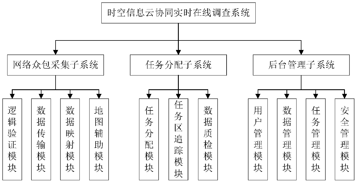
[0029] Such as figure 1 As shown, a space-time information cloud collaborative real-time online investigation system includes a network crowdsourcing acquisition subsystem, a task assignment subsystem and a background management subsystem. The network crowdsourcing acquisition subsystem is used for field investigators to update tasks, Task acceptance and field investigation data collection, the task allocation subsystem is used for ordinary administrator users to assign task areas and authority to field investigators under their jurisdiction, track the status of task areas, and review and verify external survey data. Quality inspection, the background management subsystem is used for senior administrators to manage ordinary administrators and all field investigators, data processing, upload and downl...


PUM


Abstract

The invention discloses a space-time information cloud cooperation real-time online survey system. The system comprises a network crowdsourcing acquisition subsystem, a task distribution subsystem anda background management subsystem, the network crowdsourcing collection subsystem is used for task updating, task receiving and field investigation data collection of field investigation personnel. The task distribution subsystem is used for a common administrator user to distribute task areas and authorities for field investigation personnel within the jurisdiction; wherein the background management subsystem is used for tracking the state of a task area and checking and quality inspection of field investigation data, and the background management subsystem is used for management, data processing, data result uploading and downloading and safety control of a common administrator and all field investigation personnel by an advanced administrator user. The method has the remarkable effectsthat the data integrity is good, the data security is high, the service process is simple, and the field investigation cost is reduced.

Description

technical field [0001] The invention relates to the technical field of geographical information investigation, in particular to a space-time information cloud collaborative real-time online investigation system. Background technique [0002] At present, geographic information surveys mostly use smart mobile terminal equipment for mapping instead of traditional paper-based mapping. Compared with traditional methods, smart mobile terminal mapping has greatly improved efficiency. But this method also has obvious shortcomings: [0003] 1. The surveying and mapping business is bound to the device, and the surveying and mapping user needs to carry a dedicated smart mobile terminal device, resulting in high cost of surveying and mapping, which cannot meet the needs of large-scale and multi-team work; [0004] 2. The surveying and mapping data needs to be copied from the confidential network to the smart mobile terminal, and it needs to go through multi-channel encryption desensiti...

Claims


Application Information

Patent Timeline
Patent Type & Authority Patents(China)
IPC IPC(8): G06F16/29G06Q30/02
CPCG06F16/29G06Q30/0203
Inventor 何宗李静金贤锋刘建叶胜董文杰曾攀韩维喆唐亚洲肖佳瑶刘宏达王馨怡黄潇莹周湖森郑中
Owner CHONGQING GEOMATICS & REMOTE SENSING CENT
Learn More