Computer system for displaying panoramic images along electronic map

A computer system and panoramic image technology, applied in the field of Internet geographic information, can solve the problems of increasing the server image storage burden, low efficiency of panoramic images, etc.

Active Publication Date: 2019-08-09
徐书诚
View PDF11 Cites 3 Cited by
  • Summary
  • Abstract
  • Description
  • Claims
  • Application Information

AI Technical Summary

Problems solved by technology

[0003] The technical problem to be solved by the present invention is to provide a computer system for displaying panoramic images along the electronic map, using polyline data for a segment of the line arbitrarily set on the electronic map of the terminal screen as a mathematical expression, and on this basis, advancing along the polyline Direction, according to a certain distance interval, the panoramic image extraction work is automatically carried out, without the need for image re-stitching to increase the image storage burden of the server, and to solve the problem of low efficiency of manual operation of the mouse to collect panoramic images along the line on the electronic map. The data structure of polyline, extracting point coordinates and displaying orientation; setting a set of operation variables, by receiving a series of latitude and longitude coordinates of points with start point, end point and sequence, forming a polyline with start point, end point, and direction of travel. The polyline data is stored; create an algorithm for traversing the straight line segments along the polyline to generate segmentation points according to a certain distance interval, and divide each straight line segment forming the polyline into several sub-line segments according to the traveling direction of the straight line segment and a certain interval distance, Correspondingly new segmentation points are generated and stored sequentially to form a group of panoramic image extraction points along the polyline with front and rear topological relations, display orientation, and latitude and longitude coordinates; finally, according to the algorithm of traversing the extraction points to retrieve the panoramic image, each point of the polyline and the extraction point Sequentially extract a panoramic image within a certain range covered by its points one by one. In the panoramic image window of the terminal screen, the display is directional controlled at a certain time interval. The horizontal viewing angle of the displayed panoramic image has a fixed angle with the direction of travel. The vertical angle of view is a fixed angle with the vertical direction of the relative horizontal plane. By creating a data structure and two-step traversal method, it can control and display several panoramic images along a line on the electronic map in terms of positioning, orientation, timing, and sequence. Realize the purpose of significantly improving the work efficiency of panoramic image extraction

Method used


Image

  • Computer system for displaying panoramic images along electronic map
  • Computer system for displaying panoramic images along electronic map
  • Computer system for displaying panoramic images along electronic map

Examples


Embodiment 1

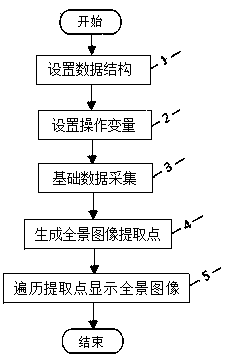
[0028] Embodiment 1, as embodiment 1 of the present invention, such as figure 1 As shown, it shows that the present invention realizes a program flow diagram of a computer system for displaying panoramic images along the electronic map, and the specific data structure uses one of the data structure designs of the present invention, such as image 3 As shown, the programming language uses JavaScript scripting language, based on HTML5 and CSS3, and the panoramic image and corresponding development tools use the panoramic image and corresponding JavaScript API configured in the "X City XX Industry Main Facilities Basic Information Management System". The system adopts B / S structure, the panoramic image in the system is a 20-megapixel professional panoramic camera, and a total of M panoramic images are taken on the selected route according to the work needs, and each panoramic image data includes the longitude and latitude coordinates of the shooting location, ID code attribute da...

Embodiment 2

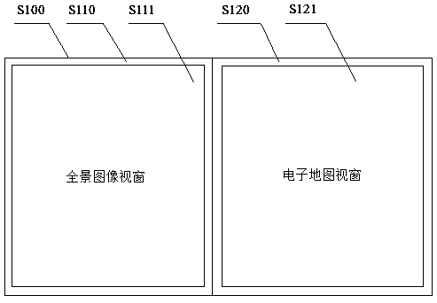
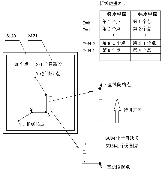
[0034] Embodiment 2, as embodiment 2 of the present invention, such as figure 1 As shown, it shows the program flow chart of the present invention to realize a computer system for displaying panoramic images along the electronic map. The specific data structure uses the second data structure design of the present invention, such as Figure 4 As shown, the programming environment can specifically use JavaScript scripting language, Tencent’s street view map JavaScript API and its network panoramic image data, with a panoramic image window in an Internet web page as a panoramic image display carrier, and an electronic map window as a polyline display carrier, Divide the left and right of the first screen S100 into two, such as figure 2 Shown, respectively from left to right specific use The label is created and named as a panoramic image window block S110 and an electronic map window block S120. First, use JavaScript scripting language to initialize Tencent’s street view ma...


PUM


Abstract

The invention discloses a computer system for displaying panoramic images along an electronic map. The system is characterized by sequentially receiving the latitude and longitude coordinates of a series of points; forming a broken line with an advancing direction to represent a set line on the electronic map; in the broken line, automatically and sequentially extracting and displaying a pluralityof panoramic images at certain intervals along the advancing direction, so that the panoramic images of the electronic map are extracted in batches and directionally displayed, the problem of automatically extracting and directionally displaying the plurality of panoramic images on a certain designated road section of the electronic map is solved, the mode of manually extracting and displaying the panoramic images of the electronic map one by one by manual operation is changed, the man-machine interaction action times are reduced, and the working efficiency of directionally displaying the panoramic images in the certain designated road section is improved.

Description

technical field [0001] The invention relates to the technical field of Internet geographic information, in particular to a computer system for displaying panoramic images along an electronic map. Background technique [0002] With the development of electronic map technology, panoramic images based on electronic maps have become a new and open resource. The panorama image acquisition method is mainly that the panorama image acquisition vehicle travels along the street at a constant speed, and takes a panorama image at a certain distance (such as 10-30 meters). Internet geographic information service platform providers provide open Platforms, such as Android, iOS, and Web development open platforms are provided free of charge to realize the call and display of electronic maps and panoramic images, and to build feature-rich and interactive electronic map applications. In the work of tour guides and route checks, it is often necessary to familiarize yourself with the route on ...

Claims


Application Information

Patent Timeline
IPC IPC(8): G06F16/954G06F16/9537
CPCG06F16/9537G06F16/954
Inventor 不公告发明人
Owner 徐书诚
Why Eureka
Try Eureka