Medium and low altitude flying unmanned aerial vehicle monitoring system

A monitoring system and low-altitude flight technology, applied to radio wave measurement systems, satellite radio beacon positioning systems, aircraft, etc., can solve the problems of lack of monitoring devices and achieve high monitoring efficiency

Pending Publication Date: 2019-08-23
太原裕昌泰科技有限公司
View PDF0 Cites 7 Cited by
  • Summary
  • Abstract
  • Description
  • Claims
  • Application Information

AI Technical Summary

Problems solved by technology

[0003] At present, there is a lack of more effective, convenient and flexible monitoring devices for low-altitude flight monitoring, such as forest protection, highway ...

Method used


Image

  • Medium and low altitude flying unmanned aerial vehicle monitoring system
  • Medium and low altitude flying unmanned aerial vehicle monitoring system
  • Medium and low altitude flying unmanned aerial vehicle monitoring system

Examples


Embodiment Construction

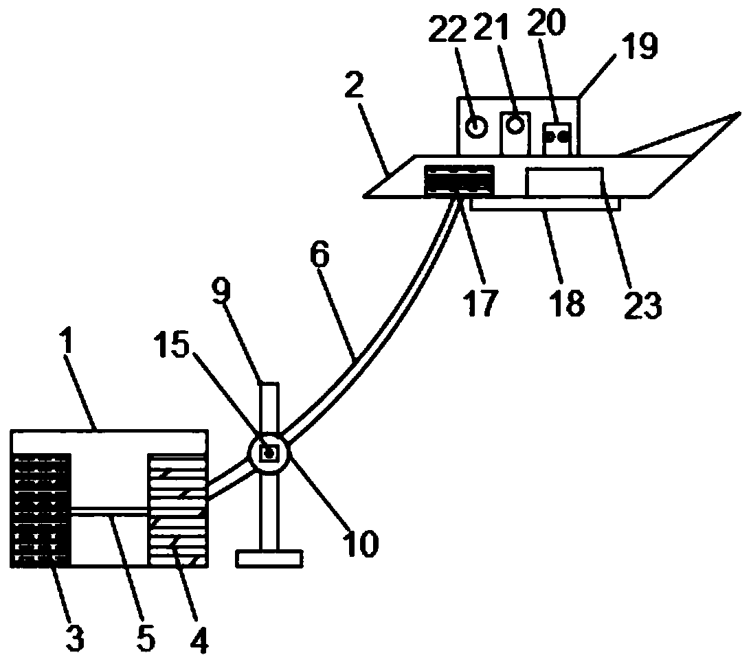
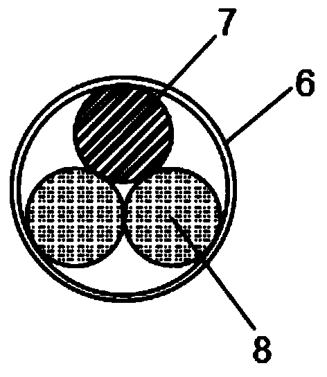
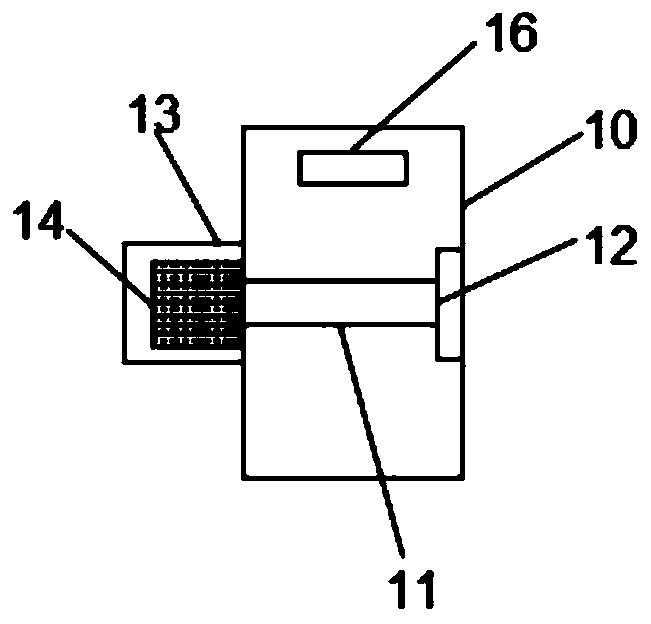
[0019] The following will clearly and completely describe the technical solutions in the embodiments of the present invention with reference to the accompanying drawings in the embodiments of the present invention. Obviously, the described embodiments are only some, not all, embodiments of the present invention. Based on the embodiments of the present invention, all other embodiments obtained by persons of ordinary skill in the art without making creative efforts belong to the protection scope of the present invention.

[0020] In the description of the present invention, it should be noted that the orientation or positional relationship indicated by the terms "vertical", "upper", "lower", "horizontal" etc. is based on the orientation or positional relationship shown in the drawings, and is only In order to facilitate the description of the present invention and simplify the description, it does not indicate or imply that the device or element referred to must have a specific o...


PUM


Abstract

The invention discloses a medium and low altitude flying unmanned aerial vehicle monitoring system. The medium and low altitude flying unmanned aerial vehicle monitoring system comprises a ground power supply assembly and an aircraft, wherein the ground power supply assembly comprises a ground electricity supply module, a low-voltage electricity supply module and a high-voltage line, a mooring cable internally comprises an electricity supply wire and two single mode fibers, a support is arranged on one side of the ground power supply assembly, a wire winding box is arranged on the support, a thermal imager, a visible light high-definition camera and a laser range finder are arranged in a monitoring box, and a central processing unit module, a GPS positioning module, a Beidou positioning module, a data transmission module and an alarm chip which are connected with one another are arranged in a control box correspondingly. According to the medium and low altitude flying unmanned aerial vehicle monitoring system, data connection is established between the aircraft and the ground in a broadband mode so that monitoring data can be acquired the first time; through a thermal imaging technology, high-definition monitoring data can be accurately acquired, and the reliable data can be provided for workers; and through a positioning system and the alarm chip, accurate position informationof an alarm place can be quickly acquired, and measures can be conveniently and quickly taken for abnormal conditions.

Description

technical field [0001] The invention relates to the field of security protection, in particular to a monitoring system for mid- and low-altitude flying unmanned aerial vehicles. Background technique [0002] Unmanned aircraft, referred to as "unmanned aerial vehicle", or "UAV" in English, is an unmanned aircraft that is controlled by radio remote control equipment and its own program control device, or is completely or intermittently operated autonomously by an on-board computer. Drones are often better suited for missions that are too "dumb, dirty or dangerous" than manned aircraft. According to the application field, UAV can be divided into military and civilian. In terms of military use, UAVs are divided into reconnaissance aircraft and target aircraft. In terms of civilian use, drones + industry applications are the real rigid needs of drones; currently, they are used in aerial photography, agriculture, plant protection, micro selfies, express delivery, disaster relief...

Claims


Application Information

Patent Timeline
IPC IPC(8): B64C39/02B64D47/08B60L53/16B60L53/18G01S17/08G01S19/33G01J5/00H04N7/18H04N5/33
CPCB64C39/02B64D47/08B60L53/16B60L53/18G01S17/08G01S19/33G01J5/0018G01J5/0066H04N7/181H04N5/33G01J2005/0077Y02T10/70Y02T90/14Y02T10/7072
Inventor 郭文林张涛赵栋凯李国胜韩晋杰
Owner 太原裕昌泰科技有限公司
Why Eureka
Try Eureka