Automatic guiding system and method applied to unmanned freight car in enclosed place

An unmanned and automatic guidance technology, applied in the control/regulation system, vehicle position/route/altitude control, motor vehicles and other directions, can solve the problems of high transformation cost and low accuracy of automatic driving navigation, and achieve flexible control. Effect

Pending Publication Date: 2019-09-20
深圳数翔科技有限公司
View PDF9 Cites 31 Cited by
  • Summary
  • Abstract
  • Description
  • Claims
  • Application Information

AI Technical Summary

Problems solved by technology

[0004] The purpose of the present invention is to solve the problems of high transformation cost and low accuracy of automatic driving navigation in existing closed sites such as wharves for unmanned driving technology, and proposes an unmanned freight vehicle that is applied to closed sites. Automatic guidance system and method for

Method used


Image

  • Automatic guiding system and method applied to unmanned freight car in enclosed place
  • Automatic guiding system and method applied to unmanned freight car in enclosed place
  • Automatic guiding system and method applied to unmanned freight car in enclosed place

Examples


specific Embodiment approach 1

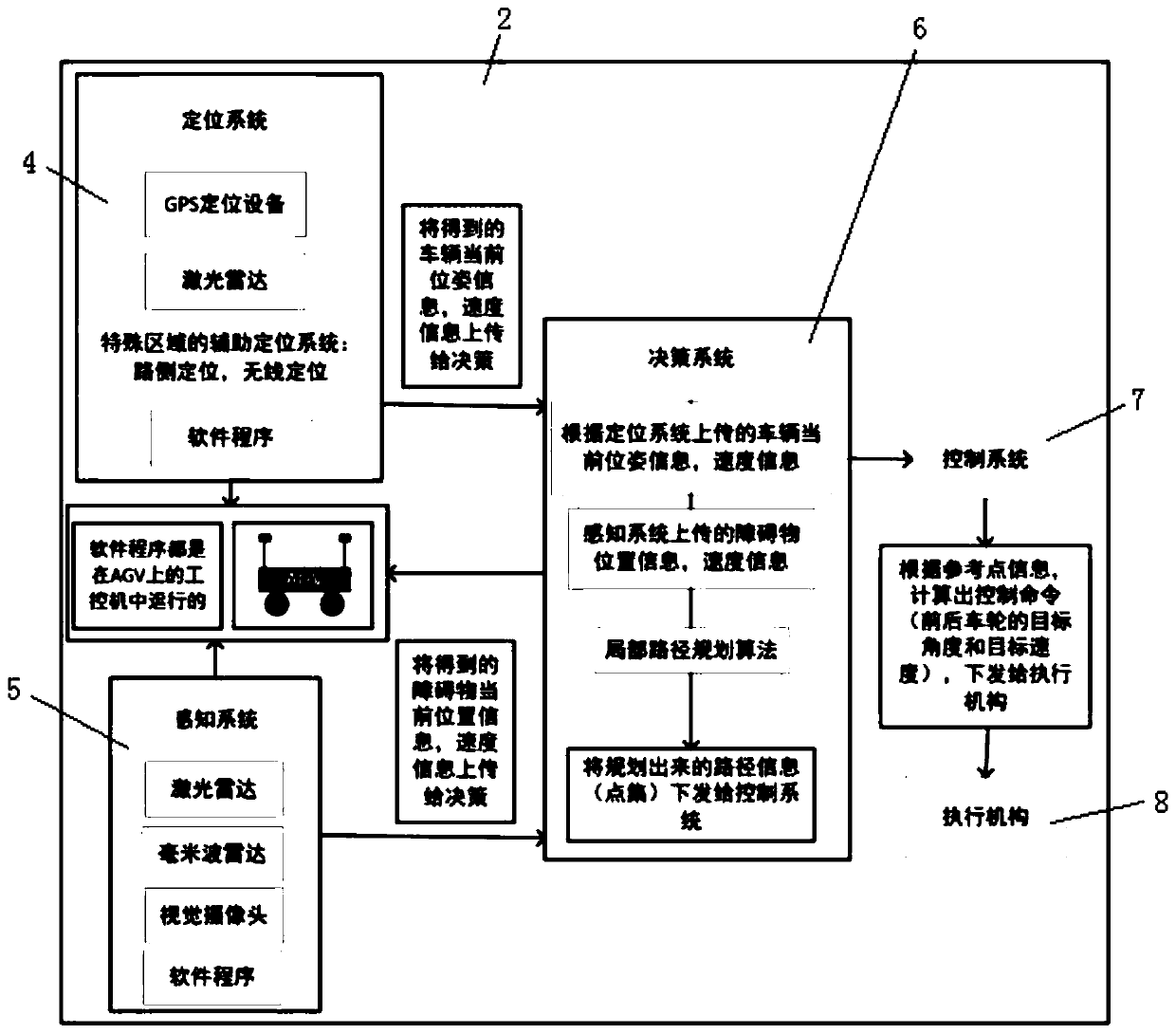
[0032] The automatic guidance system applied to unmanned freight vehicles in closed sites in this embodiment, such as figure 1 , 2 , 3, the automatic guidance system 2 includes a positioning system 4, a perception system 5, a decision system 6 and a control system 7,

[0033] The positioning system 4 adopts GPS (labeled as 2d in the figure) and inertial navigation as the main positioning system 4, and adopts the combination of the vehicle-mounted sensor group and the roadside sensor group as the auxiliary positioning system 4, which is used to combine the main positioning system 4 and the auxiliary positioning system. The accurate and stable pose information of the center point of the vehicle obtained by system 4 in real time is uploaded to decision-making system 6;

[0034] The perception system 5 uses a multi-sensor combination of laser radar 2b, millimeter wave radar 2a, and visual camera 2c to monitor the lane, detect, identify and classify obstacles, and judge the runnin...

specific Embodiment approach 2

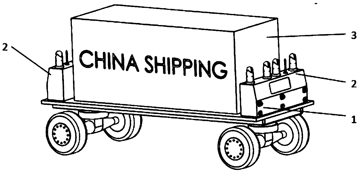
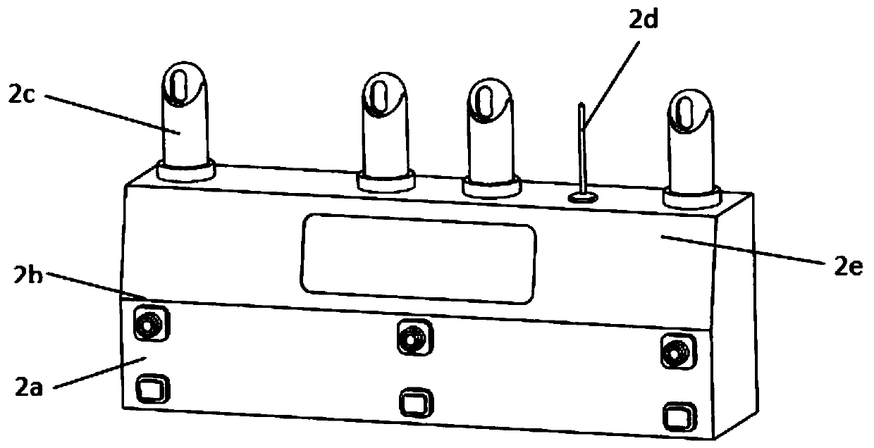
[0037] The automatic guidance system applied to unmanned freight vehicles in closed sites in this embodiment, such as figure 1 , 2 , 3, in the positioning system 4, the main positioning system 4 includes a GPS (marked as 2d in the figure) that is respectively arranged on the top of the front of the freight vehicle and the box body 2e at the rear of the truck, and the GPS (labeled as 2d in the figure) The antenna in 2d) protrudes from the surface of the box body 2e, and the gyroscope inertial navigation is selected and installed in the middle of the body 1 as the main positioning system 4; the car body 1 carries goods 3;

[0038] And the vehicle-mounted sensor group of the auxiliary positioning system 4 includes 6 laser radars 2b, 8 cameras 2c, and 6 millimeter-wave radars 2a. 2c, the combination of three millimeter-wave radars 2a is used as an auxiliary positioning system 4, a box 2e is installed at the front or rear of the car, and four cameras 2c are arranged on the top sur...

specific Embodiment approach 3

[0041] In the automatic guidance system applied to unmanned freight vehicles in a closed field in this embodiment, the perception system 5 uses the laser radar 2b group at the front and rear of the vehicle to measure the distance of the obstacle and estimate the distance of the obstacle. Running speed: Use the 2c group of on-board cameras to detect, identify and classify obstacles, and detect lanes, and use the millimeter wave radar 2a group to accurately measure the running speed information of obstacles; complete the detection and monitoring of obstacles through multi-sensor fusion technology Classify, and then output the detected obstacle distance, speed information and size information of the obstacle, and upload the obtained obstacle information to the decision-making system 6 .


PUM


Abstract

The invention relates to an automatic guiding system and method applied to an unmanned freight car in an enclosed place, belongs to the field of unmanned driving, and aims at solving the problem that application of unmanned driving to enclosed places as a harbor is high in the reconstruction cost and low in accuracy of automatic driving navigation. Main and auxiliary positioning systems obtain pose information of the central point of the car in real time; a sensing time monitors lanes by detecting, identifying and classifying barriers and determining the running speed; a decision system receives data uploaded by the positioning and sensing systems, makes a decision, and plans a local path; and a control system calculates a control command including the target angle and speed of wheels according to reference point information of the local path planned by the decision system, and issues the control command to an execution mechanism. The system and method are suitable for reconstruction automatic guidance of unmanned driving in the enclosed place, and is high in navigation precision.

Description

technical field [0001] The invention relates to an automatic guidance system and method applied to an unmanned freight vehicle in a closed field. Background technique [0002] The automatic guidance system of unmanned vehicles is mainly realized through the perception system, positioning system, decision-making system and control system. At present, the automatic guidance system of unmanned vehicles is mostly realized through various sensors on the vehicle, such as GPS positioning, laser radar, millimeter wave radar, and cameras. Since each sensor has its own usage scenarios and functions, GPS positioning is more accurate in the open and unobstructed situation. LiDAR can realize the distance measurement of obstacles and can also realize auxiliary positioning. Millimeter wave radar can realize measurement. distance and speed measurement, while the visual camera can realize lane line recognition, lane keeping, obstacle recognition and classification and other functions. In o...

Claims


Application Information

Patent Timeline
Patent Type & Authority Applications(China)
IPC IPC(8): G05D1/02
CPCG05D1/0246G05D1/0257G05D2201/0216
Inventor 毕艳飞廖志闯
Owner 深圳数翔科技有限公司
Why Eureka
Try Eureka