Improved island shoreline segmentation system and segmentation method facing remote sensing data

A technology for remote sensing data and islands, applied in image data processing, image analysis, image enhancement, etc., can solve the problems of long time period, small scale of ground objects, and high difficulty in texture recognition, achieve refined segmentation and improve the effect of extraction

Active Publication Date: 2019-09-20
SHANGHAI OCEAN UNIV
View PDF2 Cites 21 Cited by
  • Summary
  • Abstract
  • Description
  • Claims
  • Application Information

AI Technical Summary

Problems solved by technology

[0007] (1) The algorithm of image segmentation method based on deep learning relies on large-scale data sets, accurate manual labeling and long-term training, while the massive and multi-band characteristics of remote sensing images affect the computational timeliness of deep learning neural networks. sex presents a challenge
[0008] (2) Different ground features reflect different extraction accuracy under different remote sensing image band combinations, and the multi-band characteristics of remote sensing images pose a challenge to the input of deep learning models
[0009] (3) Due to the natural environment images, the spatial distribution of object categories is uneven, the scale of individual objects is small, and the texture recognition is difficult. This phenomenon poses a challenge to the sample labeling of deep learning
[0013] (1) A large number of data sets need to be accurately marked manually, which takes a long time
[0014] (2) Artificial band selection has randomness, and it is impossible to select the band combination that carries the largest amount of information for the segmentation target and the smallest information redundancy between bands
[0015] (3) It is difficult to segment the low-pixel fine-grained area of ​​the island coastline only by using the neural network method

Method used


Image

  • Improved island shoreline segmentation system and segmentation method facing remote sensing data
  • Improved island shoreline segmentation system and segmentation method facing remote sensing data
  • Improved island shoreline segmentation system and segmentation method facing remote sensing data

Examples


Embodiment

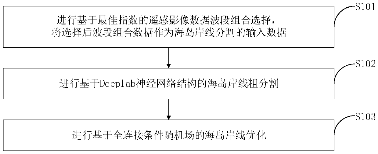
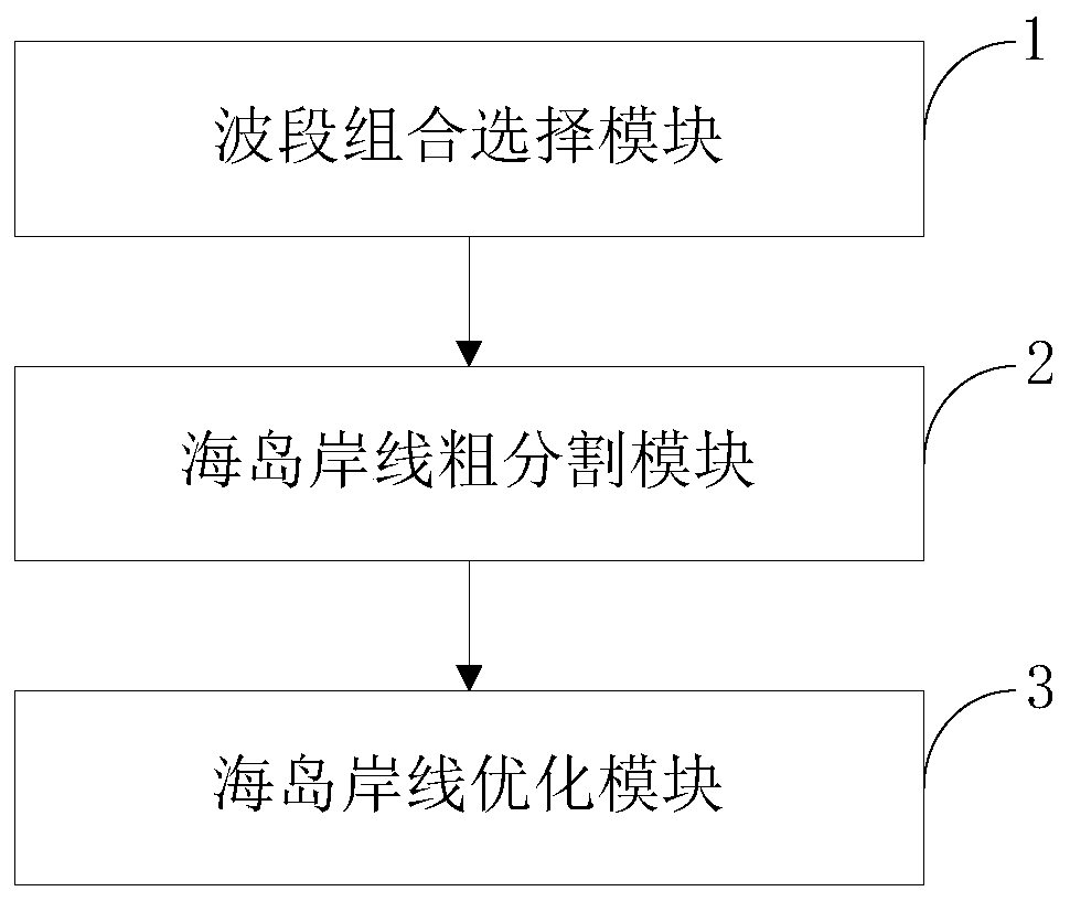
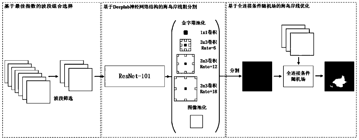
[0110] The improved island shoreline segmentation method for remote sensing data provided by the embodiment of the present invention includes:

[0111] (1) Band combination selection of remote sensing image data based on optimal index.

[0112] The Optimum Index Factor (OIF) was proposed by Professor Chavez in the United States in 1994, which is the ratio of the standard deviation of the combined band to the correlation coefficient between the bands:

[0113]

[0114] In the formula: Y i is the standard deviation of the gray value of the i-th band, and the larger the standard deviation, the higher the dispersion of information contained in the band and the richer the information. Z ij is the gray value correlation coefficient of the i-th and j-th bands, the lower the correlation coefficient, the smaller the information redundancy after band combination. n is the number of bands selected.

[0115] Remote sensing images have multi-band characteristics. Each band collects ...


PUM


Abstract

The invention belongs to the technical field of ocean remote sensing, and discloses an improved island shoreline segmentation system and segmentation method facing remote sensing data. remote sensing image data waveband combination selection based on an optimal index is carried out, and selected waveband combination data is taken as input data of island shoreline segmentation. Island shore line coarse segmentation based on a Deeplab neural network structure is carried out, and island shoreline optimization based on a full connection condition random field is carried out. The method and system are oriented to the remote sensing waveband data, and an optimal exponent formula is used for selecting a waveband combination training neural network most suitable for island shoreline segmentation; coarse segmentation and fine segmentation are carried out on the island shore line by combining a deep learning model and a probability graph model; and a 97.8% of MIoU value is obtained in the segmentation result is .

Description

technical field [0001] The invention belongs to the technical field of marine remote sensing, and in particular relates to an improved island coastline segmentation system and segmentation method for remote sensing data. Background technique [0002] Currently, the closest prior art: [0003] An island is a naturally formed land surrounded by water in the ocean and exposed to the sea level at high tide. It is a natural mosaic scattered in the vast sea. Traditional island coastline extraction has disadvantages such as difficult observation, high cost, and long cycle. Improving the accuracy and efficiency of automatic island coastline extraction has become an urgent problem to be solved. [0004] Remote sensing, as an indirect long-distance detection technology, provides important data resources for island research. Using remote sensing data, many scholars at home and abroad have studied the segmentation of island coastlines. For example, Wang Zhenhua et al. used the improve...

Claims


Application Information

Patent Timeline
Patent Type & Authority Applications(China)
IPC IPC(8): G06T7/12
CPCG06T7/12G06T2207/20081G06T2207/20084
Inventor 王振华钟元芾何婉雯曲念毅宋巍
Owner SHANGHAI OCEAN UNIV
Why Eureka
Try Eureka