Slope space deformation and damage trend calculation method

A calculation method and spatial technology, applied in the fields of disaster prevention and reduction in geotechnical engineering, deformation monitoring and landslide risk analysis, can solve the problems that the dynamic monitoring of slope deformation cannot be realized in time and early warning, and it is difficult to reflect the overall deformation status of the slope. , to reduce economic losses and avoid casualties

Inactive Publication Date: 2019-10-08
北京天下图数据技术有限公司
View PDF12 Cites 5 Cited by
  • Summary
  • Abstract
  • Description
  • Claims
  • Application Information

AI Technical Summary

Problems solved by technology

However, these two monitoring technologies can only measure the displacement of a certain point on the slope, and it is difficult to reflect the overall deformation of the slope; When the data is collected, the deformation has already occurred, and it is impossible to realize the dynamic monitoring of slope deformation and timely early warning before failure

Method used


Image

  • Slope space deformation and damage trend calculation method
  • Slope space deformation and damage trend calculation method
  • Slope space deformation and damage trend calculation method

Examples


Embodiment 1

[0061] In a specific embodiment, the technical solution of the present invention can be realized by the following methods:

[0062] (1) Slope original terrain input

[0063] First input the original topography of the slope, input the topographic contour (contour point) of the slope into the program, and then select the appropriate calculation parameters according to the size of the slope and the accuracy of the contour line (contour point), and use Kerry Golden interpolation converts contour lines (contour points) into DEM (digital elevation model), and uses the original terrain as the basis for later calculation of slope deformation.

[0064] (2) Monitoring point position input

[0065] Input the three-dimensional coordinates of each monitoring point, and its value can be relative coordinates or absolute coordinates, but it should be consistent with the coordinate system of the original terrain of the slope. Because in the later calculation process, the calculation of slope...

Embodiment 2

[0092] In order to further describe the specific implementation of the technical solution of the present invention, a specific calculation example is used to illustrate below. In this embodiment, the specific calculation formula used adopts the corresponding formula and its parameters in Embodiment 1:

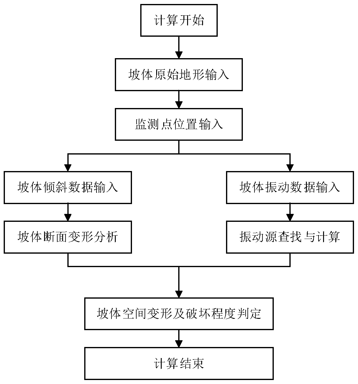
[0093] Taking the open-top deformation body located on the right bank of a certain river as an example, it was found that the slope body was deformed in November 2017, and the deformation has been accelerating since then. The length of the deformed body along the river is about 500m, the height is about 260m, and the total volume is about 4 million m 3 . Apply the method of the present invention to calculate the spatial deformation and destruction of the open-top deformable body, figure 1 It is the flow chart of realization of calculation method of slope spatial deformation and failure based on inclination and vibration characteristics. The specific calculation process is as ...

Embodiment 3

[0101] In yet another specific implementation manner, the technical solution of the present invention can also be implemented in the form of a system to execute the methods described in Embodiment 1 and Embodiment 2. This scheme can be realized in the following ways:

[0102] A calculation system for slope spatial deformation and failure tendency, said system comprising:

[0103] The data input module is used to receive the original terrain data, the coordinate data of the monitoring point, and the monitoring data of the monitoring point;

[0104] The data conversion module is used to convert the original terrain data into a digital elevation model to form the original terrain of the slope;

[0105] The single-section overall deformation module is used to obtain the slope change value of the same monitoring point twice before and after based on the shape function of the original terrain, the shape function of the section shape function after slope deformation, and the monitor...


PUM


Abstract

The invention provides a slope space deformation and damage trend calculation method and system, and belongs to the field of geotechnical engineering disaster prevention and reduction, deformation monitoring and landslide risk analysis. The inclination and vibration monitoring data of the surface of the deformed slope body are applied; slope shape function fitting, deformation space interpolation,vibration source position searching, vibration energy inverse calculation and other modes are adopted, a slope space deformation analysis model and a slope damage searching model are established in combination with original topographic data of a slope body and position information of monitoring points, and accurate calculation of the slope space deformation and damage degree is achieved. The method can quickly and effectively calculate the spatial deformation state of the side slope and the high-danger-degree and easily-damaged area of the side slope, so that powerful support is provided forreducing secondary disasters caused by the side slope and protecting the life health of personnel, and reference is provided for comprehensive treatment of the side slope.

Description

technical field [0001] The invention relates to the fields of disaster prevention and reduction in geotechnical engineering, deformation body monitoring, and landslide risk analysis, and in particular to a method and system for calculating slope space deformation and failure trend based on tilt and vibration monitoring data of a sliding slope body. Background technique [0002] As a common geological disaster, landslides will bring certain harm to people's production and life. Monitoring the deformation of slopes is an important measure to reduce the losses caused by landslides. At this stage, the monitoring of slope deformation is changing from traditional manual monitoring to automatic monitoring. How to quickly and accurately monitor slope deformation and how to know the safety status of slope through monitoring data in a timely manner is the key to reducing landslides. Disaster problems that need to be solved urgently. [0003] At present, the main technologies adopted ...

Claims


Application Information

Patent Timeline
Patent Type & Authority Applications(China)
IPC IPC(8): G06F17/50G01D21/02
CPCG01D21/02G06F30/20
Inventor 不公告发明人
Owner 北京天下图数据技术有限公司
Why Eureka
Try Eureka