
Prediction method for potential distribution of arbor forests in mountainous area

A forecasting method and arbor technology, which can be used in instruments, data processing applications, geographic information databases, etc., and can solve problems such as the distribution of meteorological stations with limited forecast accuracy in forest land.

Active Publication Date: 2019-10-11
新疆林业科学院现代林业研究所
View PDF3 Cites 2 Cited by
  • Summary
  • Abstract
  • Description
  • Claims
  • Application Information

AI Technical Summary

Problems solved by technology

[0005] In order to overcome the problem that the prediction accuracy of the potential distribution of forest land was limited by the distribution of meteorological stations in the past, the present invention provides a method for predicting the potential distribution of arbor forests in mountainous areas based on remote sensing images

Method used


Image

  • Prediction method for potential distribution of arbor forests in mountainous area
  • Prediction method for potential distribution of arbor forests in mountainous area
  • Prediction method for potential distribution of arbor forests in mountainous area

Examples


Embodiment 1

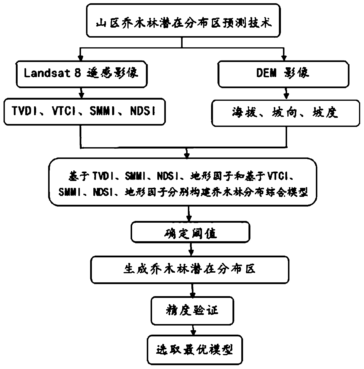
[0020] Embodiment 1: as figure 1 As shown, a method for predicting the potential distribution of arbor forests in mountainous areas includes the following steps: extract TVDI temperature vegetation drought index, VTCI conditional vegetation temperature index, and SMMI soil moisture from remote sensing image data through GIS geographic information system technology and RS remote sensing technology. Monitoring index, NDSI normalized soil index, extracting elevation, aspect, and slope data from DEM data, among which TVDI temperature vegetation drought index, VTCI conditional vegetation temperature index and SMMI soil moisture monitoring index are used as suitable factors for predicting the potential distribution of arbor forests , NDSI normalized soil index, elevation, aspect, and slope as limiting factors; respectively based on TVDI temperature vegetation drought index, SMMI soil moisture monitoring index, limiting factor and based on VTCI conditional vegetation temperature index...

Embodiment 2

[0080] Embodiment 2: as figure 1 As shown, a method for predicting the potential distribution of arbor forests in mountainous areas includes the following steps;

[0081] Step 1. Collect data from the Geospatial Data Cloud website ( http: / / www.gscloud.cn / ) download Landsat 8 Remote sensing image data and DEM image data.

[0082] Step 2, data preprocessing, using ENVI to perform preprocessing such as geometric correction, radiometric calibration, atmospheric correction, and terrain correction on remote sensing images.

[0083] Step 3, extract the temperature vegetation drought index, first use ENVI according to the mathematical model:

[0084]

[0085] Extracting land surface temperature from remote sensing images, T s is the surface temperature of any pixel, is the radiance value of any pixel, the K of Landsat8 1 =774.8853W / (m 2 *sr*μm), K 2 = 1321.0789K.

[0086] Secondly, use ENVI based on the mathematical model:

[0087] NDVI=(NIR-RED) / (NIR+RED) (2)

[0088...


PUM


Abstract

The invention discloses a prediction method for potential distribution of arbor forests in a mountainous area. The prediction method comprises the following steps: constructing an arbor forest distribution model based on a TVDI temperature vegetation drought index, an SMMI soil humidity monitoring index and a limiting factor and based on a VTCI condition vegetation temperature index, an SMMI soilhumidity monitoring index and a limiting factor, and selecting the model; extracting arbor forest distribution indexes, and respectively generating arbor forest distribution index graphs; randomly generating sample points in the range of the research area, selecting the sample points in the arbor forest according to the remote sensing images, counting the sample points to generate a scatter diagram, and performing manual debugging on the scatter diagram through visual interpretation and reference to the remote sensing images to obtain a threshold value; and deducting areas, of which normalizedsoil indexes, altitudes, slope directions and gradients are not suitable for growth of the arbor forest, from the arbor forest distribution index map to obtain an arbor forest distribution area, andfinally deducting an existing arbor forest distribution area to obtain a potential arbor forest distribution area.

Description

technical field [0001] The invention relates to a method for predicting the potential distribution of arbor forests in mountainous areas, and belongs to the technical field of predicting the potential distribution of arbor forests in mountainous areas based on remote sensing (RS) and geographic information system technology (GIS). Background technique [0002] Natural forests in mountainous areas are located between snow-covered glaciers and river systems. They have important ecological and hydrological functions of controlling energy balance and water cycle, protecting permanent snow and glaciers, intercepting and regulating mountainous precipitation and melting water from ice and snow, and at the same time have the functions of conserving water sources and purifying them. Water quality, water and soil conservation, windbreak and sand fixation and other major ecological functions bear the great responsibility of regulating ecological balance. With the growth of economic con...

Claims


Application Information

Patent Timeline
IPC IPC(8): G06F16/29G06Q50/02
CPCG06F16/29G06Q50/02
Inventor 张景路张绘芳高亚琪高健朱雅丽迪力夏提·包尔汉
Owner 新疆林业科学院现代林业研究所
Learn More