Tunnel advanced geological forecast three-dimensional modeling method and system based on BIM

A technology of advanced geological prediction and three-dimensional modeling, which is applied in the field of three-dimensional modeling of tunnel advanced geological prediction based on BIM, can solve the problems of poor modeling application effect, large interpolation fitting deviation, poor data interaction, etc., and achieve good technical support Effect

Active Publication Date: 2019-10-18
SHANDONG TRAFFIC PLANNING DESIGN INST
View PDF6 Cites 4 Cited by
  • Summary
  • Abstract
  • Description
  • Claims
  • Application Information

AI Technical Summary

Problems solved by technology

[0005]① A major feature of BIM technology is professional collaboration. GOCAD cannot be integrated and applied with general BIM software platforms, and the support for format conversion is poor. Lossless transmission, because its modeling kernel adopts Grid square grid modeling, which has a large graphics kernel difference with the Mesh triangulation modeling (IFC data standard) common to BIM technology, and there are inherent defects in format conversion, data interaction At the same time, the discrete smooth interpolation method (DSI) kernel used in its graphic generation has a large interpolation fitting deviation, which is suitable for three-dimensional geological modeling of macroscopic structures, and has poor application effect for fine exploration and advanced geological forecast volume modeling;
[0006]②At present, there is no professional database for advanced geological prediction, and the data interaction is poor. Another feature of BIM technology is data interaction and dynamic management
[0007]③The advanced geological forecast modeling process needs to call the matrix linear operation library required for interpolation and fitting calculations. GOCAD is not portable, and cannot be implemented on one platform Other professional data modeling support to ensure operation efficiency and user response
[0012] The inventor also found that the current mainstream 3D graphics modeling kernels are ACIS and Parasolid, and the format conversion and access of the advanced geological forecast interpretation results and BIM software are mainly In order to perform data conversion on the geometric level for 3D modeling, the advanced geological forecast interpretation algorithm is highly professional, highly confidential, and has a complete algorithm package and a large amount of calculation. The calculation library of the current mainstream professional software is based on large mathematical calculation libraries such as Matlab. The price is high, and these mathematical operation libraries cannot be integrated and applied in BIM software at this stage, and the program needs to be rewritten to realize

Method used


Image

  • Tunnel advanced geological forecast three-dimensional modeling method and system based on BIM
  • Tunnel advanced geological forecast three-dimensional modeling method and system based on BIM

Examples


Embodiment 1

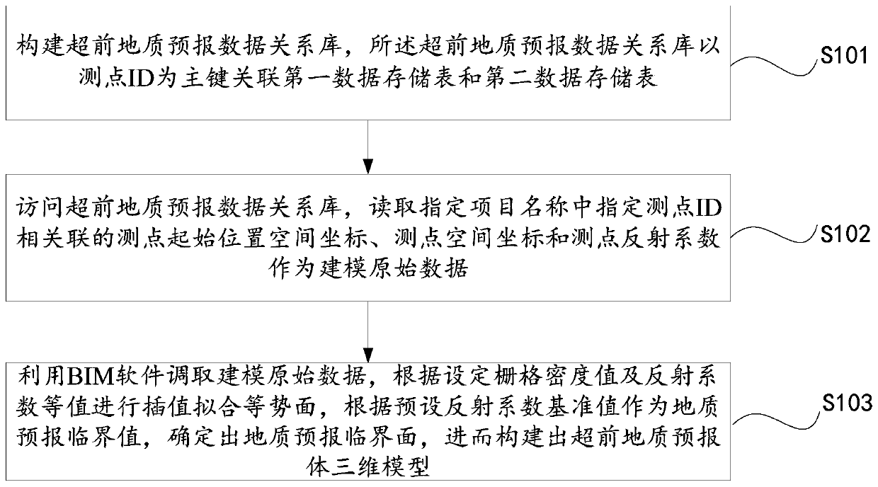
[0039] figure 1 A flow chart of a three-dimensional modeling method for advanced geological prediction of tunnels based on BIM in this embodiment is given.

[0040] Such as figure 1 As shown, the BIM-based three-dimensional modeling method for tunnel geological prediction in this embodiment includes:

[0041] S101: Constructing an advanced geological forecast data relational database, the advanced geological forecast data relational database associates the first data storage table and the second data storage table with the measuring point ID as the primary key; the first data storage table stores the measuring point ID, the measuring point The spatial coordinates of the starting position of the point and the name of the item to which the measuring point belongs; the second data storage table stores the ID of the measuring point, the spatial coordinates of the measuring point and the reflection coefficient of the measuring point.

[0042] Among them, each measuring point corr...

Embodiment 2

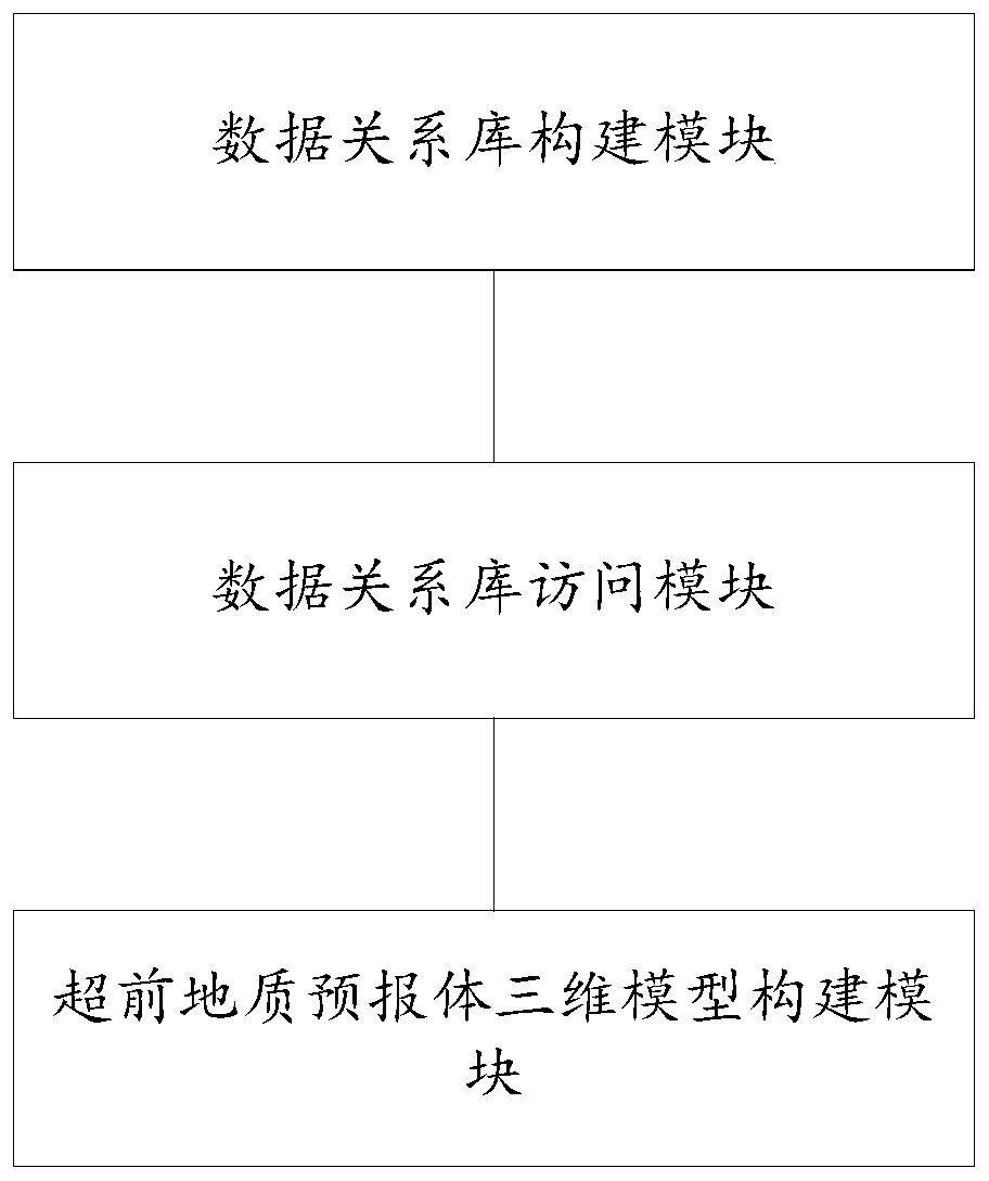
[0069] figure 2 A schematic structural diagram of a BIM-based three-dimensional modeling system for advanced geological prediction of tunnels in this embodiment is given.

[0070] Such as figure 2 As shown, the BIM-based three-dimensional modeling system for tunnel geological prediction in this embodiment includes:

[0071] (1) data relationship database construction module, which is used to build the advanced geological forecast data relationship database, the advanced geological forecast data relationship database is associated with the first data storage table and the second data storage table with the surveying point ID as the primary key; the first data The storage table stores the ID of the measuring point, the spatial coordinates of the starting position of the measuring point, and the name of the item to which the measuring point belongs; the second data storage table stores the ID of the measuring point, the spatial coordinates of the measuring point, and the refle...

Embodiment 3

[0086] This embodiment provides a computer-readable storage medium, on which a computer program is stored, and when the program is executed by a processor, the following figure 1 The steps in the BIM-based 3D modeling method for advanced geological prediction of tunnels are shown.


PUM


Abstract

The invention provides a tunnel advanced geological forecast three-dimensional modeling method and system based on BIM. The method comprises the following steps: constructing an advanced geological forecast data relationship library, wherein the advanced geological forecast data relationship library associates a first data storage table and a second data storage table by taking a measuring point ID as a main key, the first data storage table stores a measuring point ID, a measuring point initial position space coordinate and a name of a project to which the measuring point belongs, and the second data storage table stores a measuring point ID, a measuring point space coordinate and a measuring point reflection coefficient; accessing an advanced geological forecast data relationship library, and reading a measurement point initial position space coordinate, a measurement point space coordinate and a measurement point reflection coefficient associated with a specified measurement point ID in the specified project name as modeling original data; using BIM software to call modeling original data, carrying interpolation fitting of equipotential surface according to a set grid density value and reflection coefficient equivalence, taking a preset reflection coefficient reference value as a geological forecast critical value to determine a geological forecast critical surface, and thenconstructing an advanced geological forecast body three-dimensional model.

Description

technical field [0001] The disclosure belongs to the field of three-dimensional modeling for geological prediction, and in particular relates to a BIM-based three-dimensional modeling method and system for advanced geological prediction of tunnels. Background technique [0002] The statements in this section merely provide background information related to the present disclosure and do not necessarily constitute prior art. [0003] Now the mainstream BIM general graphics software recognized in the market is Revit of Autodesk, Microstation of Bentley, Catia of Dassault, etc., and its software integrates or expands a series of software suitable for structures, buildings, roads, railways, rail transit, surveying, etc. Professional modeling tools, however, the inventors found that advanced geological prediction based on BIM technology for modeling needs to rely on highly specialized algorithms, which are difficult to calculate, and interpolation and fitting algorithms are highly...

Claims


Application Information

Patent Timeline
Patent Type & Authority Applications(China)
IPC IPC(8): G06T17/05G06F16/28G06F16/22G06Q50/08
CPCG06T17/05G06F16/284G06F16/2282G06Q50/08
Inventor 赵杰徐润马汝杰王超崔永林马文琪张常勇王甲勇宋杰钟国强
Owner SHANDONG TRAFFIC PLANNING DESIGN INST
Why Eureka
Try Eureka