Method for obtaining canopy point cloud based on RTK-GPS and mobile 2D laser scanning

A two-dimensional laser and acquisition method technology, which is applied in the re-radiation of electromagnetic waves, satellite radio beacon positioning systems, measurement devices, etc., can solve the problem of inaccurate point cloud data and achieve the effect of accurate data

Inactive Publication Date: 2019-10-29
NANJING FORESTRY UNIV
View PDF4 Cites 11 Cited by
  • Summary
  • Abstract
  • Description
  • Claims
  • Application Information

AI Technical Summary

Problems solved by technology

The three methods can theoretically obtain relatively accurate canopy volume information. However, due to the actual measurement, the vibration of the vehicle during the driving process of the vehicle system and the actual driving trajectory of the vehicle are not strictly straight lines.
The point cloud data generated by the scanner is inaccurate. Therefore, it is of great significance to add GPS sensors and inertial measurement units to the vehicle-mounted laser scanning system, and to fuse the three sensor data to the measurement of the orchard canopy.

Method used


Image

  • Method for obtaining canopy point cloud based on RTK-GPS and mobile 2D laser scanning
  • Method for obtaining canopy point cloud based on RTK-GPS and mobile 2D laser scanning
  • Method for obtaining canopy point cloud based on RTK-GPS and mobile 2D laser scanning

Examples


Embodiment Construction

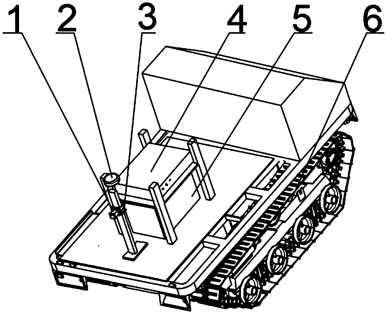
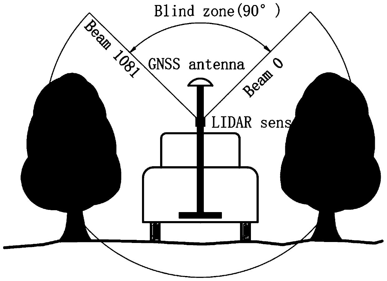
[0042] Three-dimensional green quantity measurement device for orchards based on RTK-GPS and mobile two-dimensional laser scanning, see figure 1 , which includes a two-dimensional laser scanner 1, a self-propelled vehicle 6, a GPS sensor (GPS mobile station) 2, an inertial measurement unit (IMU) 3; a data acquisition box 4. A column is fixed on the self-propelled vehicle 6, and a two-dimensional laser scanner 1 is fixed on the column, and an inertial measurement unit (IMU) 3 is arranged on the two-dimensional laser scanner 1. A GPS sensor 2 is arranged above the column. The data acquisition box 4 is electrically connected with the GPS sensor 2, the inertial measurement unit (IMU) 3, and the two-dimensional laser scanner 1, respectively, for data acquisition. The power supply 5 provided on the self-propelled vehicle 6 provides electric energy for the GPS sensor 2, the inertial measurement unit (IMU) 3, the two-dimensional laser scanner 1, and the like.

[0043] Canopy point ...


PUM


Abstract

The invention relates to a 2D laser sensor for realizing fruit tree crown volume measurement technology and GPS real-time positioning technology, in particular to a method for generating an orchard canopy geographic point cloud image based on RTK-GPS and mobile 2D laser scanning. The method comprises the following steps of: canning an orchard canopy by an onboard 2D laser scanner; mounting a GPS sensor that provides geographic location information and an inertial measurement unit (IMU) that provides vehicle body posture information on a vehicle; through a time synchronization procedure, retrieving the three-dimensional information of the point cloud from the 2D laser scanner; retrieving the geographic coordinate information of the moment from the GPS sensor; retrieving the real-time three-axis angular velocity information and angular acceleration information of the vehicle from the IMU, and obtaining the three-axis angle through real-time solution; finally, obtaining complete the orchard canopy cloud with geographic information through data fusion.

Description

Background technique [0001] Since the establishment of the Global Positioning System (GPS), it has been widely used, but its positioning accuracy cannot meet the needs of some practical applications. In order to meet these practical needs, the differential positioning technology (DGPS) has emerged. Its working principle is: place a base station GPS receiver at a fixed point with known precise coordinates to receive GPS satellite signals and calculate the system error, and then transmit the error correction parameters to the mobile station GPS receiver that is measuring the coordinates of the unknown point And eliminate the error of this point, so that the accuracy of the GPS positioning value of the mobile station is greatly improved. Carrier phase difference technology, also known as RTK technology (real time kinematics), is based on real-time processing of carrier phases of two measuring stations. It can provide real-time three-dimensional coordinates of observation points,...

Claims


Application Information

Patent Timeline
Patent Type & Authority Applications(China)
IPC IPC(8): G01S19/49G01S19/48G01S17/89
CPCG01S17/89G01S19/48G01S19/49
Inventor 周宏平杨少轻张超李秋洁施明宏
Owner NANJING FORESTRY UNIV
Why Eureka
Try Eureka