Measured geological section method based on spatial coordinates

A technology of geological profiles and spatial coordinates, applied in the field of geological surveying and mapping, can solve the problems of large amount of calculation, large number of people required, and cumbersome process of unfolded map projection map, so as to achieve the effect of convenient and fast data processing, fast post-processing, and high-efficiency collection.

Active Publication Date: 2019-11-12
POWERCHINA CHENGDU ENG
View PDF9 Cites 2 Cited by
  • Summary
  • Abstract
  • Description
  • Claims
  • Application Information

AI Technical Summary

Problems solved by technology

[0008] The present invention provides a method for actually measuring geological sections based on spatial coordinates, which solves the problems that, according to the existing methods, a la

Method used


Image

  • Measured geological section method based on spatial coordinates
  • Measured geological section method based on spatial coordinates

Examples


Embodiment Construction

[0033] The present invention will be further described below in conjunction with accompanying drawing.

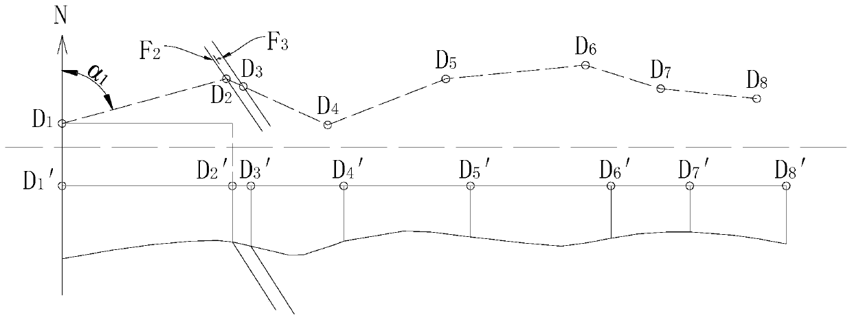
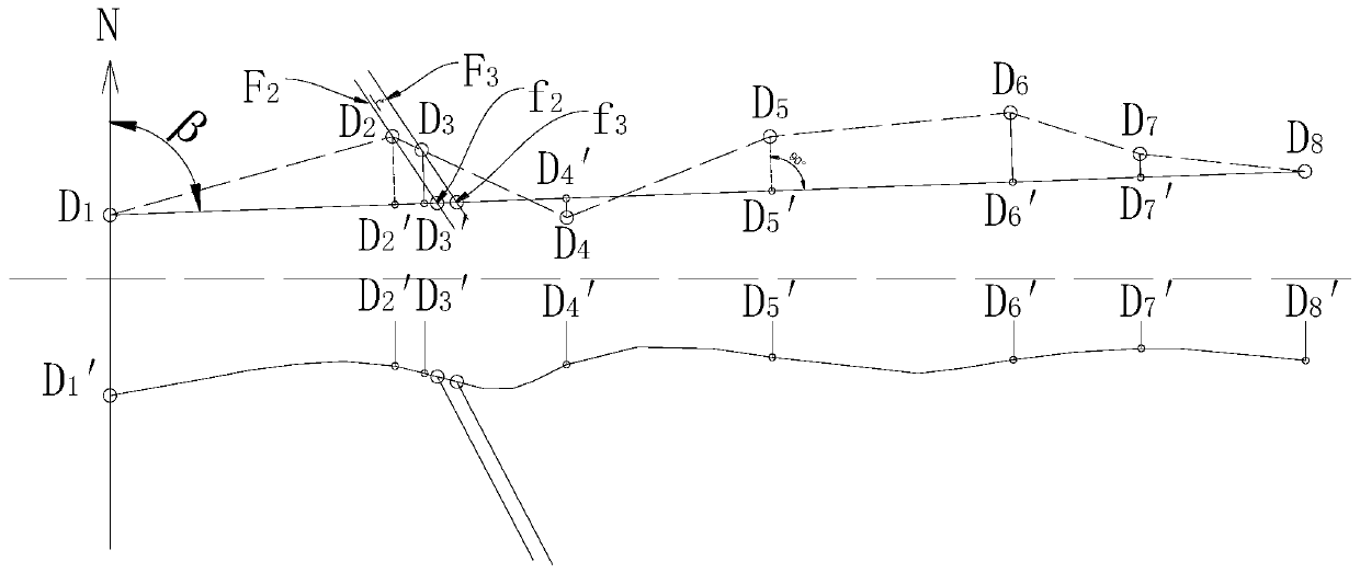
[0034] The method for measuring geological section based on spatial coordinates of the present invention includes drawing an unfolded diagram and drawing a projected diagram, wherein drawing the unfolded diagram includes the following steps:

[0035] S1. Field geological surveying and mapping

[0036] Determine the baseline in the survey area, plan the profile line, determine n geological points, and number each point as D 1 ~D n, through the mobile terminal GPS, etc. to automatically obtain the spatial coordinates of each particle, and carry out geological description and measure the occurrence of each particle. In order to facilitate statistical analysis, the principle of numbering the quality points of each place is as follows: determine the order of the points in the direction of the baseline, and then number them sequentially along the direction of the baseline. For ...


PUM


Abstract

The invention discloses a measured geological section method based on spatial coordinates, relates to the field of geological mapping, and solves the problems that the number of people required for field surveying in layered rock stratum regions according to an existing method is large, the drawing of an expansion graph and a projection drawing is large in calculation amount, and the process is cumbersome. The technical scheme is as follows: the measured geological section method based on the spatial coordinates comprises the following steps of drawing the expansion graph and drawing the projection drawing; the step of drawing the expansion graph comprises the steps of performing field geological mapping, determining a reference line, planning a section line, determining geological observation points and numbering, acquiring the spatial coordinates of the geological observation points, and performing geological description and measuring the occurrence; constructing a layered boundary surface, and constructing an expanded surface and the like; and drawing the expanded graph, drawing a terrain contour line and marking an azimuth angle, and finally obtaining the expanded graph of themeasured geological section. The step of drawing the projection drawing comprises the steps of performing field geological mapping, then organizing data, and finally obtaining the projection drawing of the measured geological section. The measured geological section method based on the spatial coordinates provided by the invention is applicable to the layered rock stratum regions.

Description

technical field [0001] The invention relates to the field of geological surveying and mapping, in particular to a method for actually measuring geological sections based on spatial coordinates, which is suitable for layered rock formation areas. Background technique [0002] The measured geological section generally starts from the old stratum and proceeds to the new stratum, that is, the baseline points from the old stratum to the new stratum. In the process of field survey, it is necessary to determine the baseline and plan the section line, in which the section line needs to pass through and have good visibility conditions. During the survey period, it is necessary to collect statistics on the rock combination, stratigraphic division, stratigraphic sequence, rock metamorphism degree, contact relationship and the characteristics of each geological unit in the work area, that is, to collect data. After the survey is completed, the data will be sorted into projection diagra...

Claims


Application Information

Patent Timeline
IPC IPC(8): G01C7/02
CPCG01C7/02
Inventor 王皓杨静熙李崇标苏建德孙云
Owner POWERCHINA CHENGDU ENG
Why Eureka
Try Eureka