Spaceborne multi-baseline holographic SAR imaging method

An imaging method and multi-baseline technology are applied in radio wave measurement systems, radio wave reflection/re-radiation, and re-radiation utilization, etc., which can solve problems such as difficult scattering characteristics, difficult interpretation of SAR images, and perspective shortening. The effect of large imaging area, high azimuth resolution and high resolution

Inactive Publication Date: 2019-11-22
SHANGHAI RADIO EQUIP RES INST
View PDF4 Cites 5 Cited by
  • Summary
  • Abstract
  • Description
  • Claims
  • Application Information

AI Technical Summary

Problems solved by technology

Since the scattering characteristics of the ground target will vary with the observation angle in the azimuth and elevation directions, it is difficult for the linear synthetic aperture technique to completely describe the scattering characteristics of the target
In addition, the linear synthetic aperture data acquisition mode has difficult imaging problems such as perspective shortening and shadows, which bring great difficulties to the interpretation of SAR images.

Method used


Image

  • Spaceborne multi-baseline holographic SAR imaging method
  • Spaceborne multi-baseline holographic SAR imaging method
  • Spaceborne multi-baseline holographic SAR imaging method

Examples


Embodiment Construction

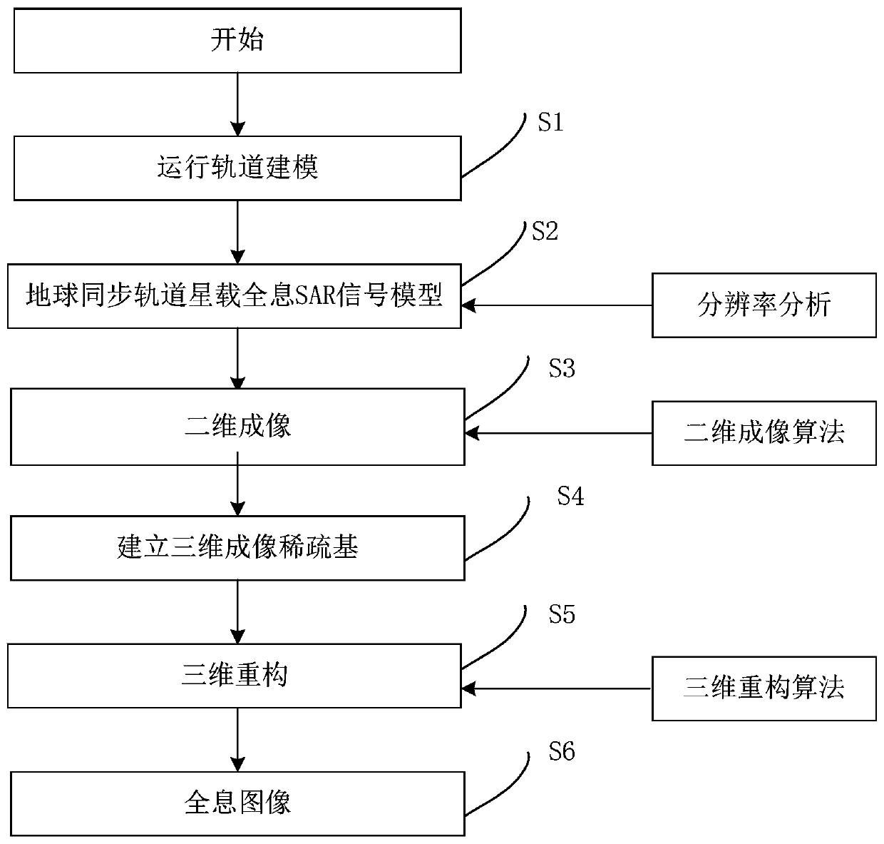
[0048]In order to make the purpose, technical solutions and advantages of the embodiments of the present invention more clear, the technical solutions in the embodiments of the present invention will be clearly and completely described below in conjunction with the drawings in the embodiments of the present invention.

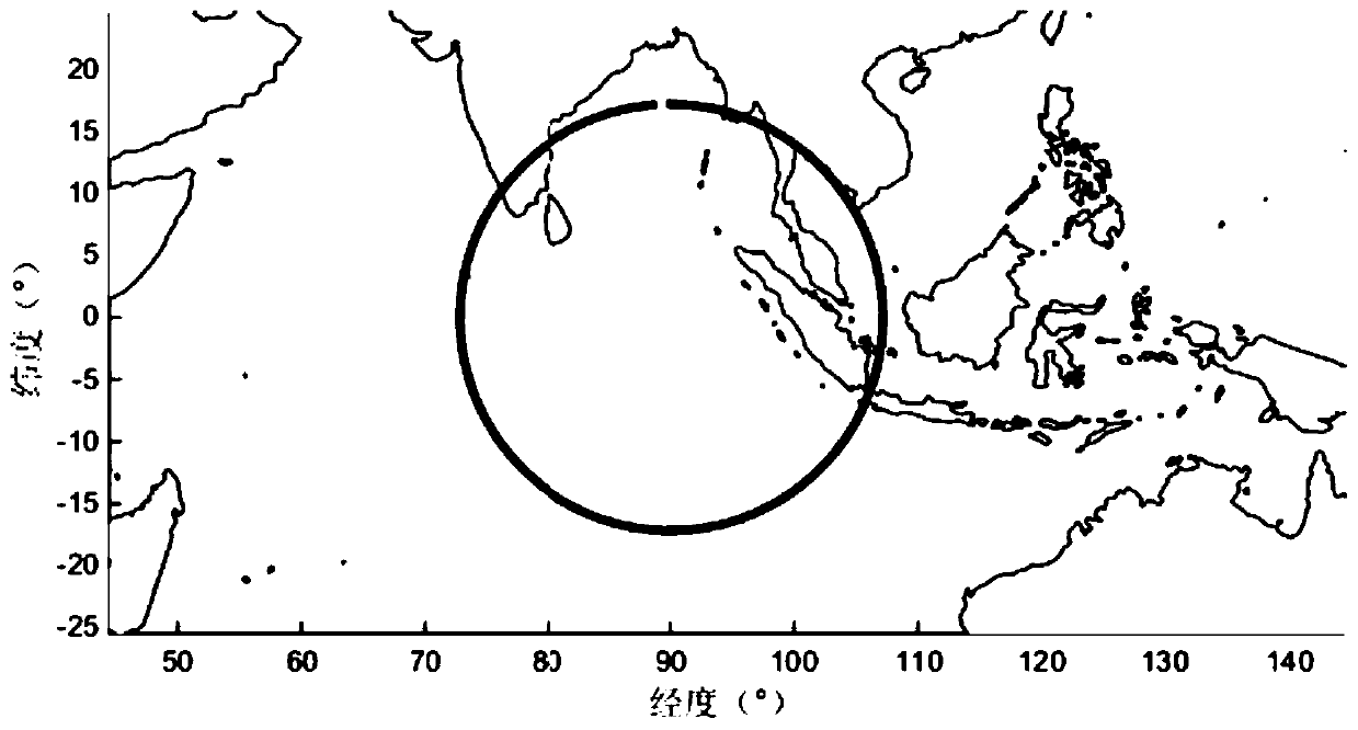
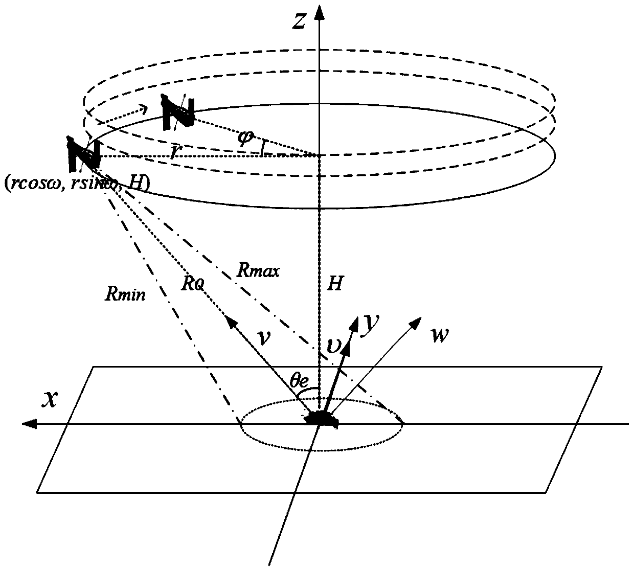
[0049] Such as figure 1 As shown, the spaceborne multi-baseline holographic SAR imaging method of the present invention uses multiple geosynchronous orbit baselines to realize scene holographic imaging. The observation path is an important guarantee for obtaining high spatial resolution, and it needs to meet the following working conditions: ① The spaceborne platform must realize a complete circular trajectory (360° angle observation can achieve the maximum resolution); The center of the area coincides; ③The circular track plane is parallel to the local horizontal plane of the observation point; the simplest satellite orbit that meets the above three conditions...


PUM


Abstract

The invention discloses a spaceborne multi-baseline holographic SAR imaging method, which realizes 360-degree omnibearing imaging based on multiple navigation geosynchronous orbit baselines. The method comprises the following steps: S1, an orbit model for geosynchronous orbit spaceborne holographic SAR imaging is constructed; S2, based on the orbit model and an imaging geometric model of the geosynchronous orbit spaceborne holographic SAR imaging, a geosynchronous orbit spaceborne holographic SAR echo signal model is constructed; S3, two-dimensional holographic imaging is carried out; S4, a three-dimensional imaging sparse basis is constructed through constructing an altitude sparse basis; S5, the altitude of a ground target is reconstructed by using a compressed sensing reconstruction algorithm; and S6, a holographic image is displayed. The problems that the airborne platform has a small detection range, the detection area is limited, and the holographic imaging quality is affected bythe movement of a carrier and the like can be solved.

Description

technical field [0001] The present invention relates to the field of SAR multi-dimensional imaging, in particular to a spaceborne multi-baseline holographic SAR imaging method. Background technique [0002] The current multi-baseline SAR 3D imaging technology uses a linear synthetic aperture to capture imaging data from one side of the scene. Since the scattering characteristics of the ground target will vary with the observation angles in the azimuth and elevation directions, it is difficult for the linear synthetic aperture technique to fully describe the scattering characteristics of the target. In addition, the linear synthetic aperture data acquisition mode has difficult imaging problems such as foreshortening and shadows, which bring great difficulties to the interpretation of SAR images. Based on the above, it is necessary to develop a spaceborne multi-baseline holographic SAR imaging method. Contents of the invention [0003] The purpose of the present invention ...

Claims


Application Information

Patent Timeline
Patent Type & Authority Applications(China)
IPC IPC(8): G01S13/90
CPCG01S13/9094G01S13/9058
Inventor 王鹏飞侯凯强姜艳娜邱晓燕施君男李伯达蒋洁吴雪微
Owner SHANGHAI RADIO EQUIP RES INST
Why Eureka
Try Eureka