Method for designing spatial information network routing strategy under SDN architecture

A space information network and SDN architecture technology, applied in the design field of space information network routing strategy, can solve the problems of different service utilization, increased satellite memory occupation and operation burden, etc.

Active Publication Date: 2019-11-22
DALIAN UNIV
View PDF4 Cites 24 Cited by
  • Summary
  • Abstract
  • Description
  • Claims
  • Application Information

AI Technical Summary

Problems solved by technology

However, this method requires the satellite to calculate the service weight to judge the service link when the service utilization rate is different, which increases the memory usage and operation burden of the satellite.

Method used


Image

  • Method for designing spatial information network routing strategy under SDN architecture
  • Method for designing spatial information network routing strategy under SDN architecture
  • Method for designing spatial information network routing strategy under SDN architecture

Examples


Embodiment Construction

[0080] The present invention will be further described below in conjunction with the accompanying drawings.

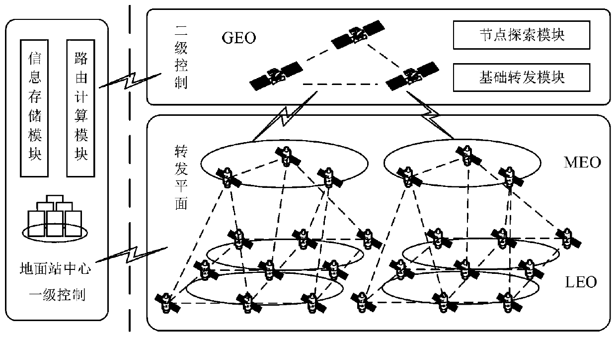
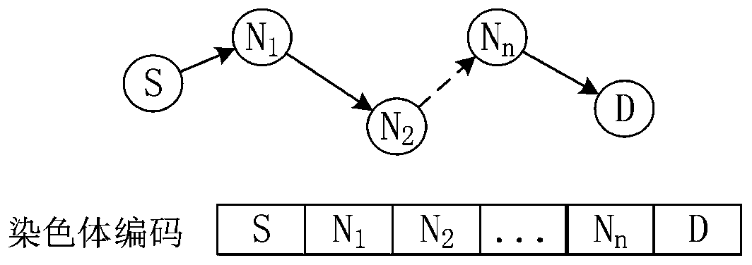
[0081] Such as figure 1 As shown, the SDN-based spatial information network routing strategy is to calculate the optimal route for each type of business through the coordinated scheduling of the entire network. The routing policy steps of the present invention's design are as follows:

[0082] Step1: The satellite exploration module of the GEO controller periodically sends LLDP data packets through the Packet_out message;

[0083] Step2: The satellite on the forwarding plane receives the data packet, and judges whether its receiving port is a controller port. If so, forward the data packet, otherwise, send the perception data packet to the controller through the Packet_in message;

[0084] Step3: The GEO controller receives the Packet_in message, obtains the topology status between the two satellite nodes, analyzes the link status information such as link bandwidth,...


PUM


Abstract

The invention discloses a method for designing a spatial information network routing strategy under an SDN architecture. The method comprises the following steps: establishing a spatial information network architecture based on a software defined network SDN; establishing a network routing model based on SDN space information; and establishing an improved genetic algorithm to solve a routing model. According to the method, the thought of SDN numerical control separation is utilized, logic is highly concentrated on a control plane, the global network state can be obtained in real time, a routing strategy is calculated, LEO and MEO do not need to calculate routing by themselves, the load of a satellite is reduced, and power consumption is reduced. Aiming at the characteristics of complex communication environment, strong node dynamics, limited on-board processing capability, various service types and the like of the spatial information network, an optimal spatial information network routing scheme is formulated under the SDN architecture, so that the transmission time delay of data forwarding of each service type in the spatial information network is reduced, and the packet loss rateis reduced.

Description

technical field [0001] The invention relates to a spatial information network routing strategy, in particular to a design method of a spatial information network routing strategy under a software-defined network (Software Defined Network, SDN) framework. Background technique [0002] The spatial information network transmits a wide variety of services, and the topological structure changes rapidly, resulting in frequent link switching or interruption, making it impossible to have a stable end-to-end link. In addition, the size and weight of satellites limit their on-board processing capabilities and cause inconvenience when calculating routes on their own, which brings great difficulties to the communication of spatial information networks. Therefore, it is of great significance to establish an effective routing strategy for the efficient operation of the spatial information network. [0003] The existing spatial information network routing is divided into single-layer rout...

Claims


Application Information

Patent Timeline
Patent Type & Authority Applications(China)
IPC IPC(8): H04L12/721H04L12/24
CPCH04L41/145H04L45/14Y02D30/50
Inventor 杨力潘成胜蔡睿妍孔志翔滕奇秀
Owner DALIAN UNIV
Why Eureka
Try Eureka