Point-line-plane three-dimensional point-by-point well depth design method

A well depth design and three-dimensional technology, applied in geophysical surveying, instruments, etc., can solve the problems of complex and variable thickness and speed of the speed-down zone, inaccurate well depth, and low precision of surface structure investigation, achieving strong systematization and implementability effectiveness, ensuring rationality and accuracy, and improving accuracy

Active Publication Date: 2019-11-26
CHINA PETROLEUM & CHEM CORP +1
View PDF10 Cites 5 Cited by
  • Summary
  • Abstract
  • Description
  • Claims
  • Application Information

AI Technical Summary

Problems solved by technology

The thickness and velocity of low and low-speed zones are complex and changeable. The traditional small refraction and micro-logging methods have low accuracy in surface structure surveys, and it is difficult to establish an accurate near-surface model of the piedmont zone. The depth of the excitation well designed based on this is inaccurate. , affecting the quality of seismic data and the subsequent near-surface correction

Method used


Image

  • Point-line-plane three-dimensional point-by-point well depth design method
  • Point-line-plane three-dimensional point-by-point well depth design method
  • Point-line-plane three-dimensional point-by-point well depth design method

Examples


Embodiment Construction

[0036] In order to make the above and other objects, features and advantages of the present invention more comprehensible, the preferred embodiments are listed below and shown in the accompanying drawings in detail as follows.

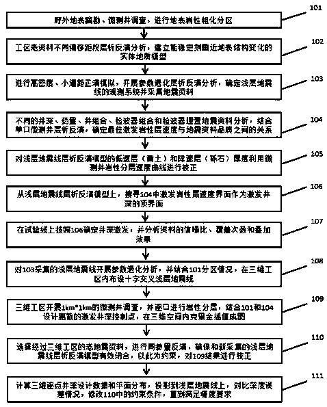
[0037] like figure 1 as shown, figure 1 It is a flow chart of the point-line-plane three-dimensional point-by-point well depth design method of the present invention.

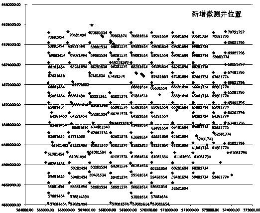
[0038] Step 101, field surface survey and lithology division;

[0039] Step 102, establishing a near-surface forward modeling model for tomographic inversion of old data in the work area;

[0040] Step 103, design the acquisition parameters of the shallow seismic line by forward modeling; carry out high-density, small track spacing forward modeling, carry out parameter degradation tomographic inversion analysis, determine the observation system of the shallow seismic line and collect seismic data;

[0041] Step 104, selecting test points and researching excitation receiving factors t...


PUM


Abstract

The invention provides a point-line-plane three-dimensional point-by-point well depth design method. The method includes: step one, carrying out tomography inversion on different offset sections by using old data of a work area to obtain a near-surface forward model; step two, designing forward modeling shallow seismic line acquisition parameters; step three, searching for a velocity correspondence relationship of an inversion model of a shallow seismic line for correction and carrying out correction; step four, searching for a velocity interface of exciting the lithostrome on based on the corrected shallow seismic line tomographic inversion model; step five, carrying out 1km*1km micrologging surveying on the work area, carrying out lithological layering layer by layer, and carrying out 3Dinterpolation to form a well depth design map; step six, carrying out same-parameter tomographic inversion on old data through a 3D work area and constraining and correcting a result in the step five; and step seven, 3D point-by-point excitation well depth designing and mapping of the work area old data and shallow seismic line tomographic inversion constraining. With the provided method, the rationality and accuracy of the mountain data excitation well depth design can be guaranteed effectively, so that the quality of seismic data collection is improved and the good foundation is laid for improving the imaging accuracy of prestack depth migration.

Description

technical field [0001] The invention relates to the technical field of oilfield development, in particular to a point-line-plane three-dimensional point-by-point well depth design method. Background technique [0002] The surface undulations and surface structure of mountainous areas vary greatly. Due to the influence of complex conditions on the surface, near the surface, and underground, interference waves develop in areas with low signal-to-noise ratio, and the quality of seismic data is poor. The problem of static correction that affects the processing effect of seismic data is very prominent. , so the importance of surface structure investigation is undoubted, and accurate investigation results can also provide accurate basis for well depth design. At present, the mainstream mountain surface survey method is to use the encounter observation method or the chasing shot observation method in the small refraction method according to the conventional density, and only use th...

Claims


Application Information

Patent Timeline
Patent Type & Authority Applications(China)
IPC IPC(8): G01V11/00
CPCG01V11/00
Inventor 滕厚华尚新民赵胜天李继光崔庆辉金昌昆王蓬
Owner CHINA PETROLEUM & CHEM CORP
Why Eureka
Try Eureka