Remote sensing image data storage method and system

A data storage system and remote sensing image technology, applied in the field of remote sensing, can solve the problems of large storage space, low sharing efficiency, and difficult retrieval, and achieve the effects of reducing storage space occupation, improving storage efficiency, and improving retrieval speed.

Active Publication Date: 2019-12-20
GUANGZHOU URBAN PLANNING & DESIGN SURVEY RES INST
View PDF5 Cites 17 Cited by
  • Summary
  • Abstract
  • Description
  • Claims
  • Application Information

AI Technical Summary

Problems solved by technology

However, the redundancy of remote sensing data is high, resulting in a large storage space; when it is transmitted across the network, it is limited by the influence of network broadband, and the sharing efficiency is low; when there are too many images stored, the storage is chaotic and the retrieval is difficult. There are obvious deficiencies in quick access and search capabilities
[0004] (2) A massive remote sensing image data storage management system built on the basis of traditional relational databases. There are two ways to implement this method: the first is to expand the space of the relational database management system to enable it to manage raster data. However, these softwares have relatively weak management capabilities for RSID (Romote Sensing Image Data, remote sensing image data). Promoted by major GIS vendors
However, with the requirements of massive data and the development of related applications, it is difficult for traditional relational databases to meet the storage requirements of all images when dealing with unstructured data written in large quantities, with unstable table structures and fields, resulting in information a certain degree of loss

Method used


Image

  • Remote sensing image data storage method and system
  • Remote sensing image data storage method and system
  • Remote sensing image data storage method and system

Examples


Embodiment Construction

[0060] The technical solutions in the embodiments of the present invention will be clearly and completely described below in conjunction with the accompanying drawings in the embodiments of the present invention. Obviously, the described embodiments are only a part of the embodiments of the present invention, rather than all the embodiments. Based on the embodiments of the present invention, all other embodiments obtained by those of ordinary skill in the art without creative work shall fall within the protection scope of the present invention.

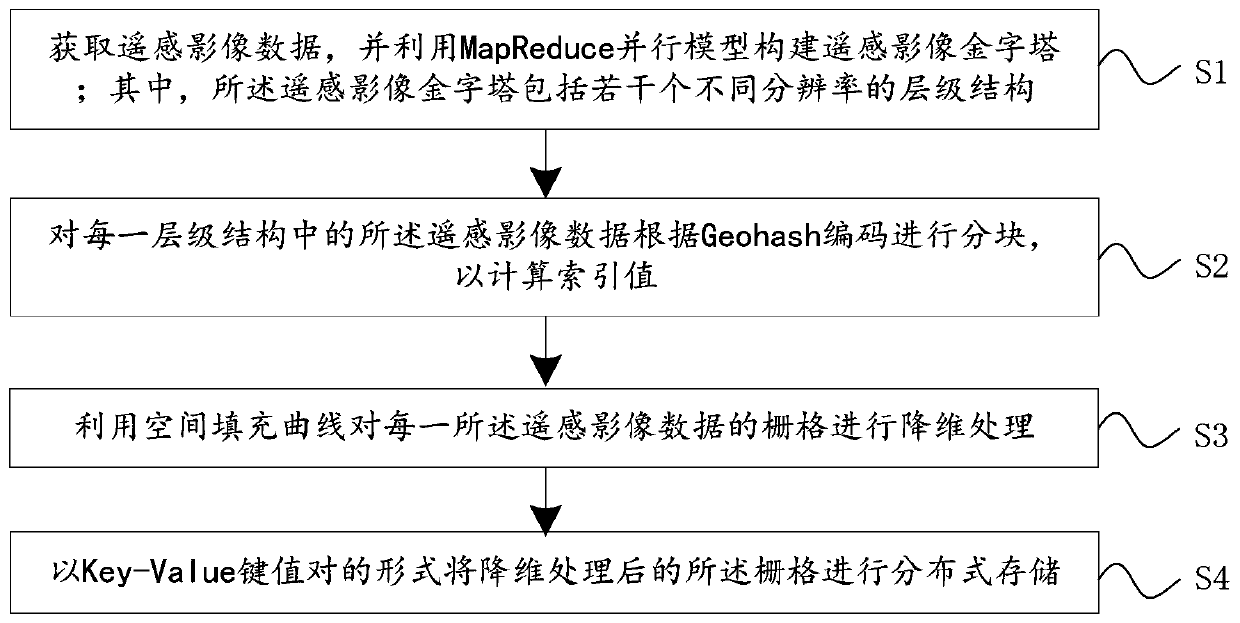
[0061] See figure 1 , figure 1 It is a flowchart of a remote sensing image data storage method provided by an embodiment of the present invention; including:

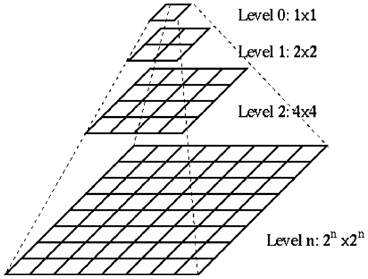
[0062] S1. Obtain remote sensing image data, and use the MapReduce parallel model to construct a remote sensing image pyramid; wherein, the remote sensing image pyramid includes several hierarchical structures with different resolutions;

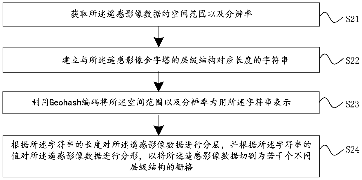
[0063] S2. The remote sensing image data in e...


PUM


Abstract

The invention discloses a remote sensing image data storage method which comprises the following steps: acquiring remote sensing image data, and constructing a remote sensing image pyramid by utilizing a MapReduce parallel model; wherein a remote sensing image pyramid comprises a plurality of hierarchical structures with different resolutions; partitioning the remote sensing image data in each hierarchical structure according to Geohash coding so as to calculate an index value; performing dimension reduction processing on the grid of each piece of remote sensing image data by utilizing a spacefilling curve; and carrying out distributed storage on the grids subjected to the dimension reduction processing in a Key-Value key value pair form. The invention further discloses a remote sensing image data storage system. By adopting the embodiment of the invention, massive remote sensing image data can be effectively stored in the distributed data storage database, the storage efficiency is improved, tile data of different levels can be called according to requests of different resolutions, and efficient indexes are provided for reading and querying the tile data.

Description

Technical field [0001] The present invention relates to the field of remote sensing technology, in particular to a remote sensing image data storage method and system. Background technique [0002] With the rapid development of remote sensing technology, the amount of remote sensing data with multi-sensor, multi-temporal, high spatial resolution, and high spectral resolution is also increasing, and the data types are becoming more and more complex, including non-imaging hyperspectral reflectance data, Satellite remote sensing image data, research area attribute data, etc. Due to the periodic accumulation of remote sensing data in all directions, a large number of remote sensing images are acquired every day. The volume of remote sensing data is very large. If the comprehensive analysis and fusion processing of different types of remote sensing data in multiple periods in a certain area, the data volume will become a geometric multiple increase. The existing remote sensing data ...

Claims


Application Information

Patent Timeline
Patent Type & Authority Applications(China)
IPC IPC(8): G06T7/10G06F16/22G06F16/27
CPCG06T2207/10036G06T2207/20016G06T7/10G06F16/2228G06F16/27
Inventor 刘洋郭亮何华贵杨卫军王会林鸿曾志铧
Owner GUANGZHOU URBAN PLANNING & DESIGN SURVEY RES INST
Why Eureka
Try Eureka