Method for converting surveying and mapping completion drawings into surveying delimitation drawings in batches

A technology for as-built drawings and batches, applied in data processing applications, geometric CAD, calculations, etc., can solve the problems of low quality and low efficiency of reconnaissance boundary drawings, achieve good application prospects, improve work efficiency and quality, and reduce labor. effect of intervention

Active Publication Date: 2020-01-14
CHUZHOU UNIV
View PDF7 Cites 2 Cited by
  • Summary
  • Abstract
  • Description
  • Claims
  • Application Information

AI Technical Summary

Problems solved by technology

[0004] The present invention aims at reducing the quality of manual conversion and improving work efficiency in order to solve the problems of low quality and low efficiency of surveying and delimitation maps generated by manual modification of existing surveying and mapping completion drawings, and provides a batch automatic conversion method

Method used


Image

  • Method for converting surveying and mapping completion drawings into surveying delimitation drawings in batches
  • Method for converting surveying and mapping completion drawings into surveying delimitation drawings in batches
  • Method for converting surveying and mapping completion drawings into surveying delimitation drawings in batches

Examples


Embodiment Construction

[0028] The present invention will be further described below in conjunction with the accompanying drawings and embodiments.

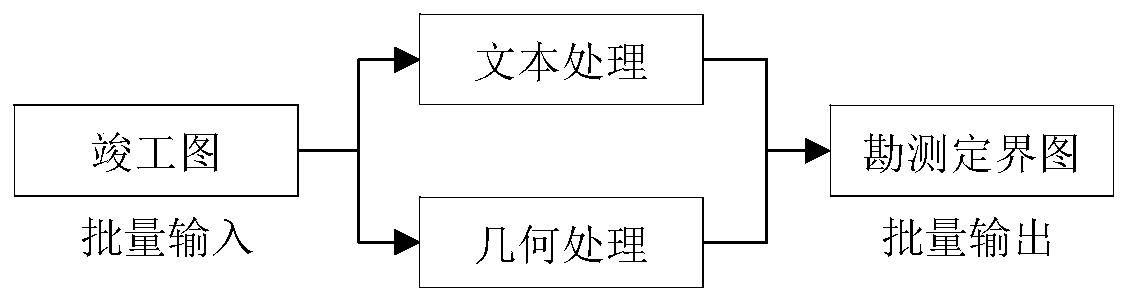
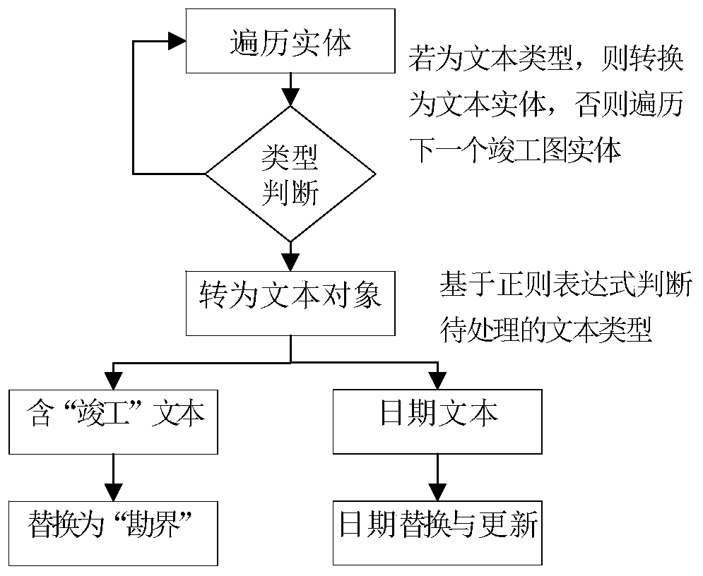
[0029] The present invention combines the drafting standards and norms of the existing as-built drawings and demarcation maps for surveying and mapping, and establishes the conversion process from as-built drawings to survey and demarcation drawings, including data traversal and analysis of as-built drawings, text information processing, and geometric information processing in reclamation areas and demarcation map output.

[0030] This example uses Windows 7 as the operating system environment, Microsoft visual studio 2010 as the development environment, C# as the development language, AutoCAD2007, CASS7.1 as the platform, *. The technology is implemented under the framework of .NET3.5.

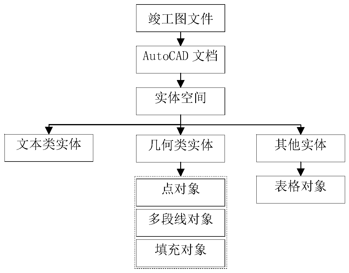
[0031] 1. Traverse and analyze the as-built drawing data, including the following steps:

[0032] Step 1 traverse the files in the as-built drawing path

[0033] Tr...


PUM


Abstract

The invention discloses a method for converting surveying and mapping completion drawings into surveying delimitation drawings in batches, which comprises the following steps of: (1) acquiring all entity objects in a completion drawing working space, and analyzing completion drawing data; (2) for the text object, respectively replacing and adjusting according to the text content and the spatial position of the corresponding text in the survey delimitation graph; for a geometric object, extracting boundary lines of a project area and a fixed work area by utilizing a text matching and space logic judgment method, searching and deleting all land type elements in the project area, and performing symbolic expression on the boundary lines and an internal area by adopting a symbolic expression method; for the table object, creating an area statistical table by adopting a method of first positioning and then in-situ replacement; (3) storing the processed completion drawing file to the same path through a text replacement method; according to the method, the manual intervention degree of traditional surveying and mapping completion drawing conversion is reduced, and the working efficiency and quality of land reclamation are improved.

Description

technical field [0001] The invention relates to the field of information-based surveying and mapping and drawing, in particular to a method for batch-converting surveying and mapping as-built drawings into surveying and demarcation drawings. Background technique [0002] Land reclamation and reclamation is the key content of my country's land planning and consolidation work, which can effectively promote the flow of land use indicators and economic and social development in various provinces, cities and regions in my country. Land evacuation and reclamation completion maps and survey and demarcation maps are important map materials for measuring and accepting land vacancy and reclamation work. Figure 1 In the actual surveying and mapping work, the various land uses are scattered and the plots are fragmented. The measurement workload of the two maps is heavy and there are many repeated measurements, especially in areas with large elevation fluctuations such as mountains and h...

Claims


Application Information

Patent Timeline
Patent Type & Authority Applications(China)
IPC IPC(8): G06F30/12G06Q10/10
CPCG06Q10/10
Inventor 陈泰生王本林王春陈梦琳李伟涛谷双喜
Owner CHUZHOU UNIV
Why Eureka
Try Eureka