Web-end three-dimensional GIS software design method with geographic space data confidentiality

A geospatial data and software design technology, applied in the field of geographic information systems, can solve problems such as data downloading to the local area and data leakage, and achieve the effect of avoiding data leakage, avoiding waste of resources, and good visualization effects

Inactive Publication Date: 2020-01-21
吉奥时空信息技术股份有限公司
View PDF5 Cites 3 Cited by
  • Summary
  • Abstract
  • Description
  • Claims
  • Application Information

AI Technical Summary

Problems solved by technology

And accessing data in different regions through multiple IPs, there is still a way to download all the data to the local, resulting in data leakage

Method used


Image

  • Web-end three-dimensional GIS software design method with geographic space data confidentiality
  • Web-end three-dimensional GIS software design method with geographic space data confidentiality
  • Web-end three-dimensional GIS software design method with geographic space data confidentiality

Examples


Embodiment Construction

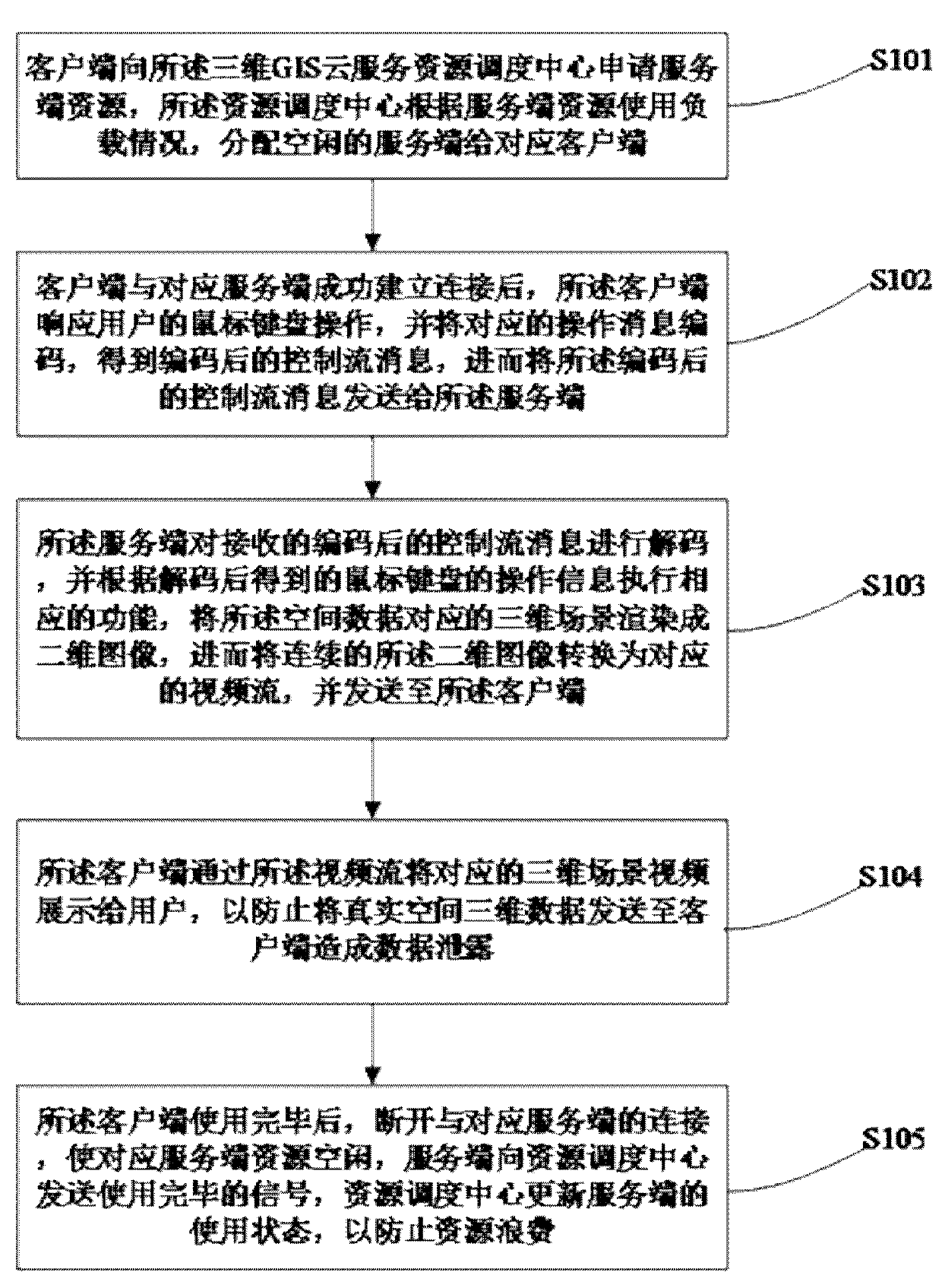
[0029] In order to have a clearer understanding of the technical features, purposes and effects of the present invention, the specific implementation manners of the present invention will now be described in detail with reference to the accompanying drawings.

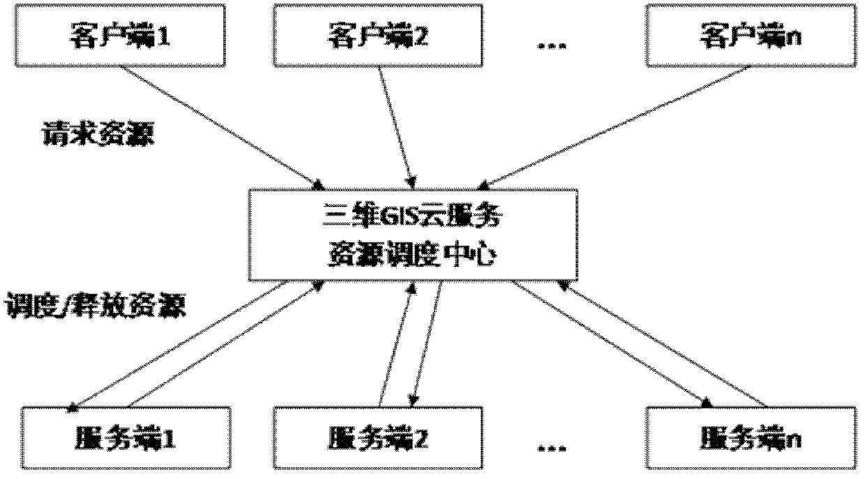
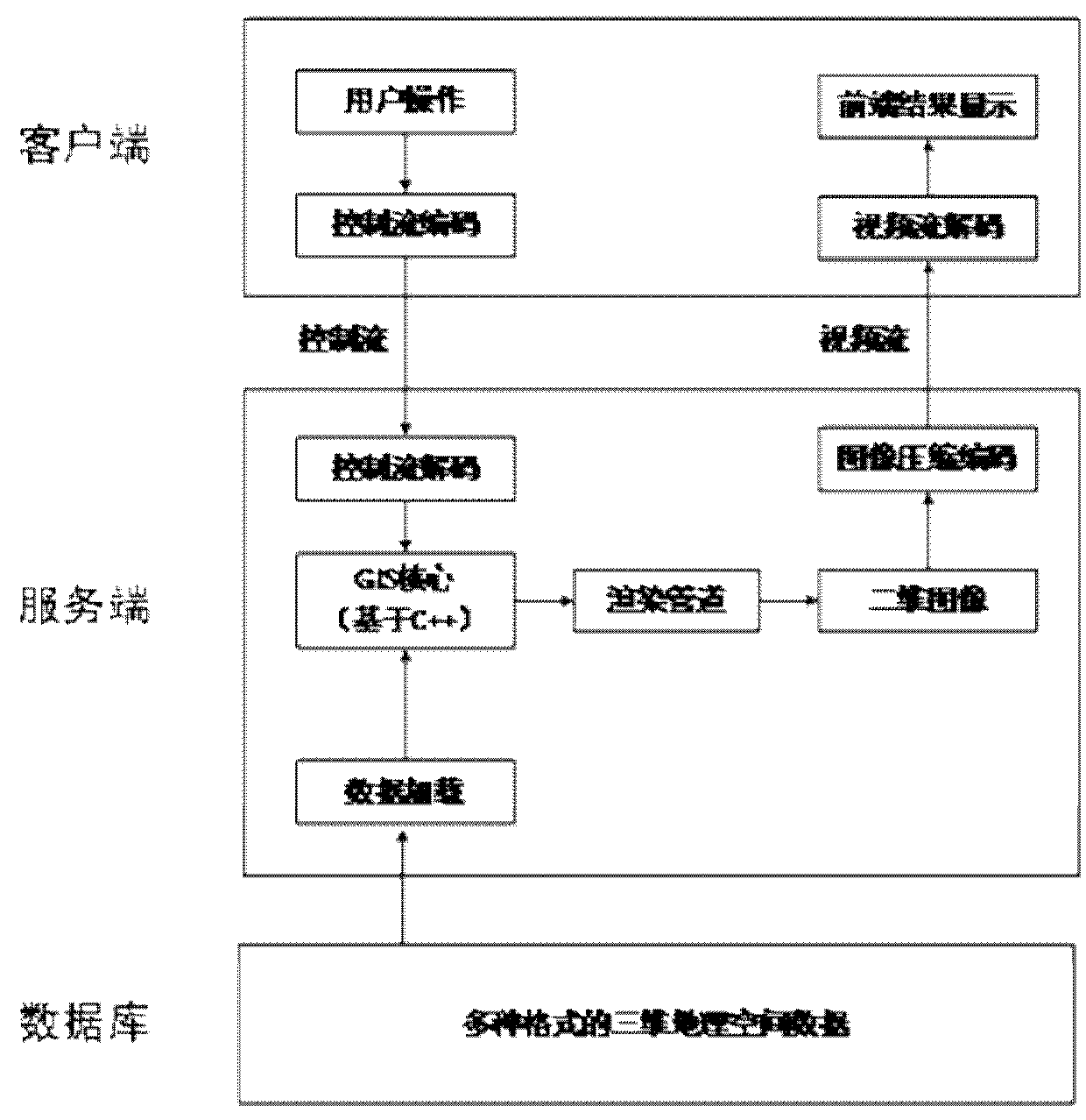
[0030] Embodiments of the present invention provide a method for designing Web-side three-dimensional GIS software with confidentiality of geospatial data, which is applied to such as figure 2 As shown in a Web-side 3D GIS software with geospatial data confidentiality, such as image 3 Shown is a data transmission flow diagram between a single client and a server in an embodiment of the present invention; said a kind of Web-end three-dimensional GIS software with geospatial data confidentiality includes: a three-dimensional GIS cloud service dispatching center, a client , a server, and a database; there are multiple clients and the server, and multiple clients communicate with multiple servers, and there is a two-way c...


PUM


Abstract

The invention provides a Web-end three-dimensional GIS (geographic information system) software design method with geographic spatial data confidentiality. The method comprises the following steps that: a client applies for server resources from a three-dimensional GIS cloud service resource scheduling center, and the resource scheduling center allocates idle servers to the client; the client sideresponds to mouse and keyboard operation of the user and encodes the corresponding operation message to obtain an encoded control flow message, and then the encoded control flow message is sent to the server side; the server decodes the received encoded control flow message; the method comprises the following steps: receiving space data, decoding the space data, executing a corresponding functionaccording to operation information of a mouse and a keyboard obtained after decoding, rendering a three-dimensional scene corresponding to the space data into a two-dimensional image, converting thetwo-dimensional image into a corresponding video stream, and sending the video stream to a client to prevent data leakage caused by sending real space three-dimensional data to the client; the serverside is provided with an image buffer area compatible with the OpenGL and the Directx. The method has the advantages that data leakage is effectively avoided, and graphics card resources are reasonably utilized.

Description

technical field [0001] The invention relates to the technical field of geographic information systems, in particular to a design method for three-dimensional GIS software on the Web with geographic space data confidentiality. Background technique [0002] At present, the demand for 3D GIS on the web page is increasing. Users hope to load 3D GIS large scenes on the web page and browse smoothly, and require the ability to perform professional GIS spatial analysis and other operations. [0003] Most of the existing web-side 3D GIS software uses WebGL technology. WebGL, or Web Graphics Library, is a set of JavaScript APIs for rendering interactive two-dimensional and three-dimensional graphics. It is compatible with any web browser and does not require any plug-ins. The well-known 3D GIS open source engine developed based on WebGL technology is Cesium. Therefore, many domestic software developers develop their own web-side 3D GIS software based on Cesium. [0004] However, ba...

Claims


Application Information

Patent Timeline
Patent Type & Authority Applications(China)
IPC IPC(8): G06F9/50G06F9/54G06F3/0487G06F3/0489G06F21/62H04L29/08
CPCG06F3/0487G06F3/0489G06F9/505G06F9/548G06F21/6218G06F2209/549H04L67/02H04L67/1008H04L67/141H04L67/143
Inventor 张立宁牟明贾宏邢侃侃肖超燕斐余勇兵郭洁张雨泽李新圆李敏祝知博
Owner 吉奥时空信息技术股份有限公司
Why Eureka
Try Eureka