Navigation enhancement system based on low-orbit constellation monitoring GNSS signals and broadcasting GNSS frequency band navigation enhancement signals

A low-orbit constellation and signal enhancement technology, applied in the field of satellite navigation enhancement, can solve problems such as co-frequency transceiver interference, and achieve the effect of reducing deployment, saving costs, and real-time high-precision positioning

Inactive Publication Date: 2020-02-14
XIAN INSTITUE OF SPACE RADIO TECH
View PDF9 Cites 13 Cited by
  • Summary
  • Abstract
  • Description
  • Claims
  • Application Information

AI Technical Summary

Problems solved by technology

[0003] The technical problem solved by the present invention is: to overcome the deficiencies of the existing technology, provide a navigation enhancement system based on low-orbit constellation monitoring GNSS signals and broadcast GNSS frequency band navigation enhancement signals, solve the same-frequency transceiver interference problem, and solve the global low-orbit The problem of satellite navigation enhancement can be applied to my country's low-orbit navigation enhancement system in the future

Method used


Image

  • Navigation enhancement system based on low-orbit constellation monitoring GNSS signals and broadcasting GNSS frequency band navigation enhancement signals
  • Navigation enhancement system based on low-orbit constellation monitoring GNSS signals and broadcasting GNSS frequency band navigation enhancement signals
  • Navigation enhancement system based on low-orbit constellation monitoring GNSS signals and broadcasting GNSS frequency band navigation enhancement signals

Examples


Embodiment Construction

[0028] The present invention will be further described in detail below in conjunction with the accompanying drawings and specific embodiments.

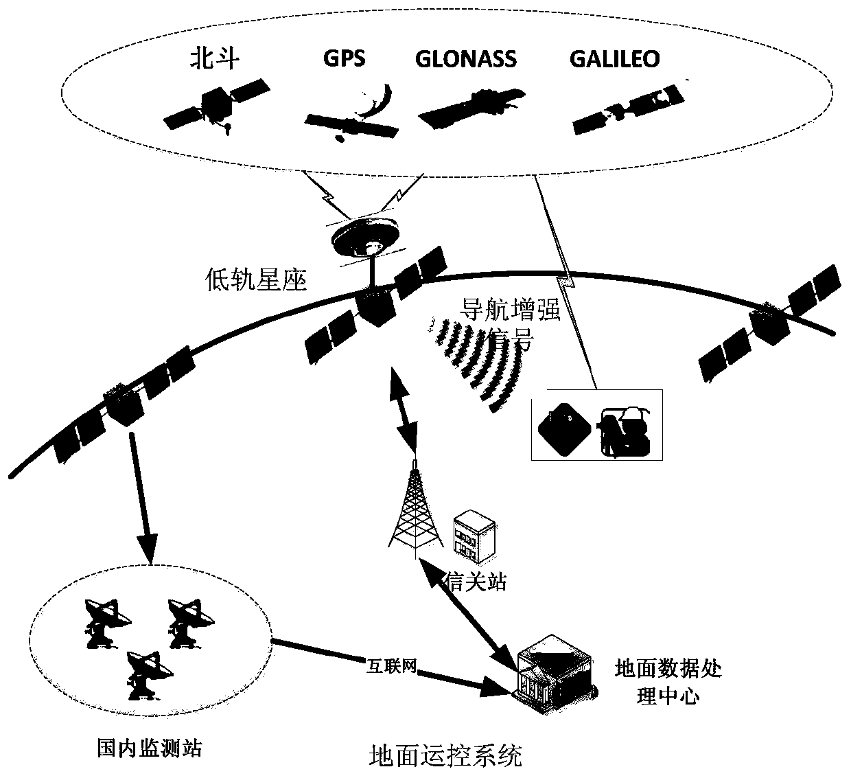
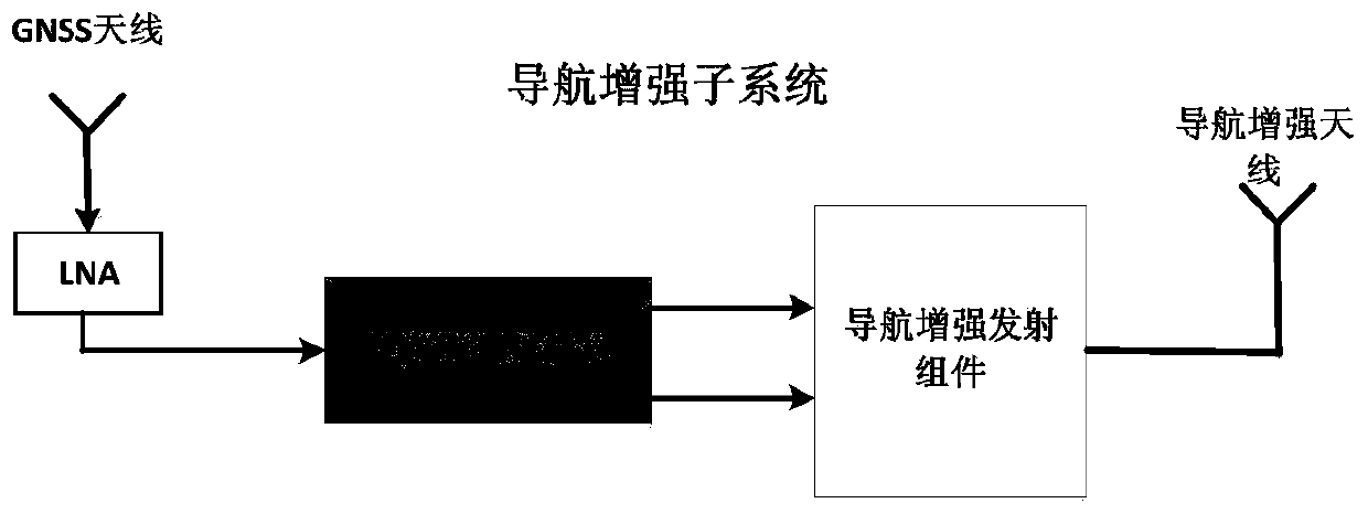
[0029] The present invention is a navigation enhancement system based on low-orbit constellation monitoring GNSS signals and broadcasting GNSS frequency band navigation enhancement signals, including: low-orbit constellation, operation and control system, and navigation terminal; the operation and control system monitors and receives navigation signals, and obtains navigation signals monitoring data, and transmit the monitored monitoring data back to the operation and control system; the operation and control system, according to the monitoring data returned by the LEO constellation and the monitoring data monitored by the operation and control system, generates the navigation satellites and low The corrected parameters of the orbit, clock error, code bias (DCB) and carrier phase bias (FCB) of each orbit constellation are framed to obt...


PUM


Abstract

The invention discloses a navigation enhancement system based on low-orbit constellation monitoring GNSS signals and broadcasting GNSS frequency band navigation enhancement signals. The system comprises a low-orbit constellation, a transportation control system and a navigation terminal. The transportation control system monitors and receives navigation signals, obtains monitoring data of the navigation signals, and transmits the monitoring data obtained through monitoring back to the transportation control system. The transportation control system generates correction parameters of respectiveorbits, clock differences, code Deviations (DCB) and carrier phase deviations (FCB) of navigation satellites and the low-orbit constellation of four GNSS systems according to the monitoring data transmitted back by the low-orbit constellation and the monitoring data monitored by the transportation control system, carries out framing to obtain navigation enhancement data, uploads the navigation enhancement data to the low-orbit satellites, carries out modulation and coding on broadcasting data to form the navigation enhancement signals, and broadcasts the navigation enhancement signals to thenavigation terminal. The navigation terminal carries out high-precision positioning, speed measurement and time service calculation, solves the problem of same-frequency receiving and transmitting, and achieves low-orbit navigation enhancement.

Description

technical field [0001] The invention relates to a navigation enhancement system based on low-orbit constellation monitoring GNSS signals and broadcasting GNSS frequency band navigation enhancement signals, that is, a navigation enhancement system based on multiple navigation signals, which belongs to the technical field of satellite navigation enhancement. Background technique [0002] It is currently a critical period for the Beidou satellite navigation system to transition from regional to global. However, the Beidou navigation signal is limited by international regulations with low landing power and is easily interfered and blocked. It is difficult to build stations uniformly around the world, making it difficult to realize global continuous monitoring of military and civilian signals; the demand for high-precision GNSS services has expanded from regional to global, and it is difficult to meet fast high-precision positioning, speed measurement and timing calculations only ...

Claims


Application Information

Patent Timeline
Patent Type & Authority Applications(China)
IPC IPC(8): G01S19/02G01S19/05G01S19/20G01S19/29G01S19/30G01S19/25
CPCG01S19/02G01S19/05G01S19/20G01S19/256G01S19/29G01S19/30
Inventor 边朗蒙艳松严涛王瑛张蓬刘玉洁雷文英贾亦哲
Owner XIAN INSTITUE OF SPACE RADIO TECH
Why Eureka
Try Eureka