Instant positioning and map construction method suitable for dynamic environment

A map construction and dynamic environment technology, applied in 3D modeling, image enhancement, image analysis, etc., can solve the problems of high memory usage and difficult real-time performance

Active Publication Date: 2020-02-21
GUANGDONG UNIV OF TECH
View PDF9 Cites 21 Cited by
  • Summary
  • Abstract
  • Description
  • Claims
  • Application Information

AI Technical Summary

Problems solved by technology

However, due to the semantic segmentation of each frame of image, it is difficult for the system to achieve real-time performance on the mobile platform, and the dense point cloud map is established, which consumes a lot of memory.

Method used


Image

  • Instant positioning and map construction method suitable for dynamic environment
  • Instant positioning and map construction method suitable for dynamic environment
  • Instant positioning and map construction method suitable for dynamic environment

Examples


Embodiment Construction

[0056] The present invention will be further described in detail below in conjunction with the embodiments and the accompanying drawings, but the embodiments of the present invention are not limited thereto.

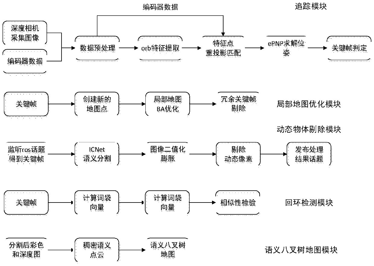
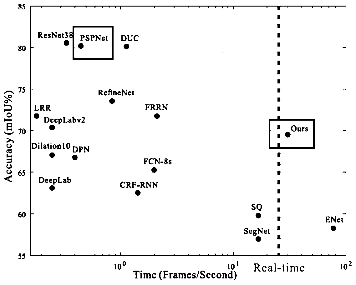
[0057] The present invention proposes a real-time positioning and map construction method suitable for dynamic environments. On the basis of the DS_SLAM system, the encoder data is incorporated to make the tracking part in the dynamic environment more robust, and only for the key frame part Carry out image segmentation, and use the image segmentation results only for the mapping part, which greatly shortens the time; in addition, it also innovatively combines the semantic segmentation network on the TensorFlow platform. Compared with the semantic segmentation network under the traditional caffe framework, the new network It has better performance; the new network introduces the multi-node communication mechanism of the ros system, and opens up a node thread for semantic s...


PUM


Abstract

The invention discloses an instant positioning and map construction method suitable for a dynamic environment, and the method comprises the following steps: firstly carrying out the external parametercalibration of a depth camera and an encoder, and obtaining a transformation matrix from the coordinates of the encoder to the coordinates of the depth camera; layering each frame of image acquired by the depth camera by using an image pyramid, and extracting ORB feature points from each layer of the image pyramid; taking the data obtained by the encoder as a constant-speed model of the trackingmodule, then projecting the feature points of the key frame of the previous frame onto the current frame, matching the feature points with the feature points of the current frame, and performing triangulation on the successfully matched key points to obtain a pose between the two frames. According to the invention, the tracking part uses encoder data as an initial pose during camera re-projection,accurate positioning tracking in a dynamic environment is realized, and compared with a traditional semantic slam tracking module which needs to remove dynamic pixels from each frame, amount of timeis saved.

Description

technical field [0001] The invention relates to the technical field of mobile robot positioning, navigation and mapping, in particular to an instant positioning and map building method suitable for dynamic environments. Background technique [0002] Slam (Simultaneous Localization and Mapping) is widely used in fields such as mobile robots, drones and augmented reality. However, in dynamic environments, traditional slam systems are not robust. In a real scene full of dynamic objects, the tracking module in the classic slam system like ORB_SLAM will fail. What's worse, the classic slam system builds a static map, which cannot remove dynamic objects from the map, resulting in the map being completely Not available. In order to solve the problem of how to make the slam system applicable to dynamic scenes, many papers and documents have given different solutions. DS_SLAM is one of the effective solutions, which performs semantic segmentation on each frame of the input image. ...

Claims


Application Information

Patent Timeline
Patent Type & Authority Applications(China)
IPC IPC(8): G06T17/00G06T17/05G06T7/10
CPCG06T17/005G06T17/05G06T7/10G06T2207/10028G06T2207/20081
Inventor 陈文峰蔡述庭李丰徐伟峰
Owner GUANGDONG UNIV OF TECH
Why Eureka
Try Eureka