A Remote Sensing Rapid Determination Method of Water Volume and Storage Capacity of Dammed Lakes Without Underwater Topographic Data

A technology for rapid determination of underwater topography, applied in the field of remote sensing spatial information, to achieve the effect of reducing data dependence, reducing computational intensity, and avoiding limitations

Active Publication Date: 2022-02-01
XUZHOU NORMAL UNIVERSITY
View PDF0 Cites 0 Cited by
  • Summary
  • Abstract
  • Description
  • Claims
  • Application Information

AI Technical Summary

Problems solved by technology

[0005] Purpose of the invention: In view of the strong dependence of the existing lake water volume remote sensing measurement algorithm on underwater terrain data and the problem of how to quickly and accurately obtain scientific water volume data of barrier lakes in the absence of underwater terrain data, the present invention proposes A Remote Sensing Rapid Determination Method of Barrier Lake Water Storage Capacity Without Underwater Topographic Data

Method used


Image

  • A Remote Sensing Rapid Determination Method of Water Volume and Storage Capacity of Dammed Lakes Without Underwater Topographic Data
  • A Remote Sensing Rapid Determination Method of Water Volume and Storage Capacity of Dammed Lakes Without Underwater Topographic Data
  • A Remote Sensing Rapid Determination Method of Water Volume and Storage Capacity of Dammed Lakes Without Underwater Topographic Data

Examples


Embodiment 1

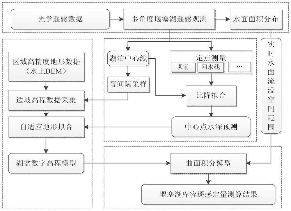
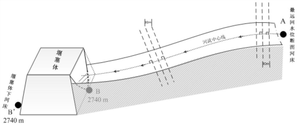
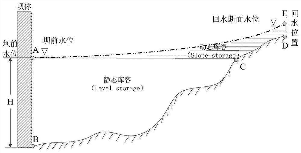
[0038] refer to figure 1 , this embodiment provides a remote sensing rapid measurement method for the volume and storage capacity of barrier lakes without underwater terrain data, using existing optical remote sensing images and digital elevation model data, through local gradient estimation and segmented adaptive fitting As well as discrete surface integration, it solves the problems of difficulty in obtaining underwater terrain data and timeliness of information acquisition, and effectively improves the accuracy and efficiency of estimating the water volume of barrier lakes in areas with incomplete data. The accurate determination of lake storage capacity and the drawing of storage capacity curves based on complete remote sensing are realized, which provides an efficient method for rapid remote sensing estimation and monitoring of plateau barrier lake water volume without underwater terrain data. At the same time, the remote sensing rapid determination method of the water vo...


PUM


Abstract

The invention discloses a remote sensing rapid determination method of water volume and storage capacity of a barrier lake without underwater terrain data. The steps are as follows: S1: extracting the submerged area of ​​the water area of ​​the barrier lake under the shade of the mountain body; S2: according to the water area distribution of the barrier lake, Calculate the position of the centerline of the polygon of the barrier lake; S3: Based on the position of the centerline, conduct fixed-point elevation measurement of the barrier lake and estimate the elevation of the centerline of the lake bed; S4: estimate and combine the elevation measurement with the elevation of the centerline of the lake bed Slope elevation information, adaptive simulation of the unknown underwater terrain of the barrier lake; S5: According to the simulated underwater terrain and the submerged area of ​​the barrier lake water area, the reservoir capacity of the barrier lake is calculated by using the discrete integral of the three-dimensional surface space. The invention avoids the limitations of traditional means, reduces data dependence, effectively improves the timeliness of information and the accuracy and efficiency of water volume estimation of barrier lakes in areas with incomplete data, and realizes accurate measurement and measurement of water volume of barrier lakes based on complete remote sensing. The storage capacity curve is drawn.

Description

technical field [0001] The invention relates to the technical field of remote sensing space information, in particular to a rapid remote sensing method for determining the water volume and storage capacity of a barrier lake without underwater terrain data. Background technique [0002] The size of the storage capacity of the barrier lake is the most critical factor in determining the risk of barrier lake failure and an important reference for leadership decision-making in the work of risk reduction. Generally speaking, the greater the water storage capacity, the greater the security threat, the more serious the disaster caused by the collapse, and the impact force is extremely dangerous. Therefore, real-time grasp of storage capacity dynamics and accurate real-time forecasting of water volume are of great significance for the assessment of plateau barrier lakes' danger assessment, disaster deduction, safety management, comprehensive management, and establishment of early war...

Claims


Application Information

Patent Timeline
Patent Type & Authority Patents(China)
IPC IPC(8): G01C13/00G01C11/00
CPCG01C13/00G01C11/00Y02A90/30
Inventor 朱长明张新王伟胜
Owner XUZHOU NORMAL UNIVERSITY
Why Eureka
Try Eureka