Highway pavement disease positioning method based on unmanned aerial vehicle

A positioning method and unmanned aerial vehicle technology, applied in the direction of roads, roads, road repairs, etc., can solve the problems of slow detection speed, discovery, detection and positioning limitations, a large amount of manpower and material resources, etc., to achieve stable detection frequency, fast detection speed, The effect of less manpower requirement

Pending Publication Date: 2020-03-20
SOUTHEAST UNIV +1
View PDF0 Cites 8 Cited by
  • Summary
  • Abstract
  • Description
  • Claims
  • Application Information

AI Technical Summary

Problems solved by technology

This method has the problems of high detection cost, slow detection speed, a large amount of manpower and material resources, and the detection accuracy is greatly affected by factors such as the detection level, work experience, and physiolog

Method used


Image

  • Highway pavement disease positioning method based on unmanned aerial vehicle
  • Highway pavement disease positioning method based on unmanned aerial vehicle
  • Highway pavement disease positioning method based on unmanned aerial vehicle

Examples


Embodiment Construction

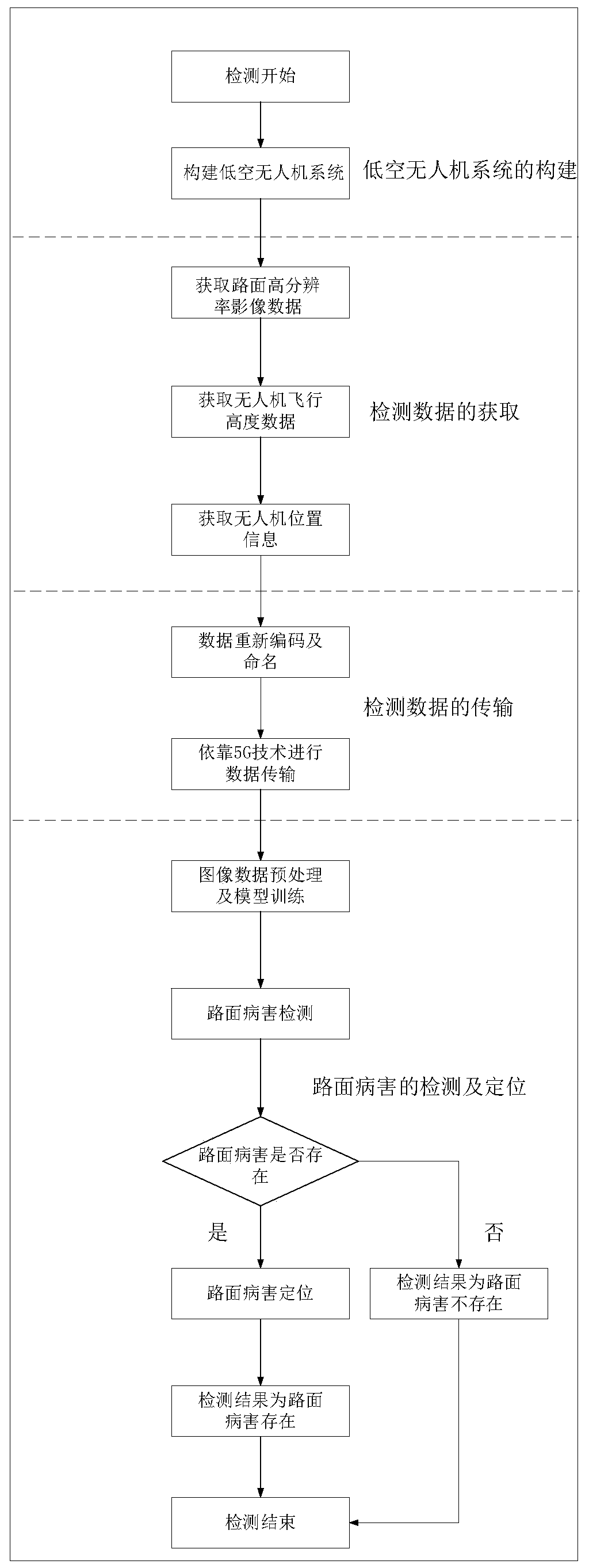
[0043] The specific implementation process of the present invention is further described below in conjunction with the drawings and specific examples, but the scope of application of the present invention is not limited in any way.

[0044] figure 1 It is a flowchart of the method for locating road pavement diseases based on UAV proposed in the present invention, including the following steps:

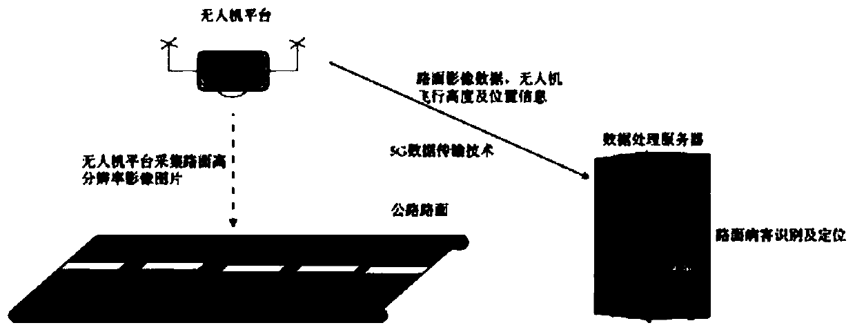
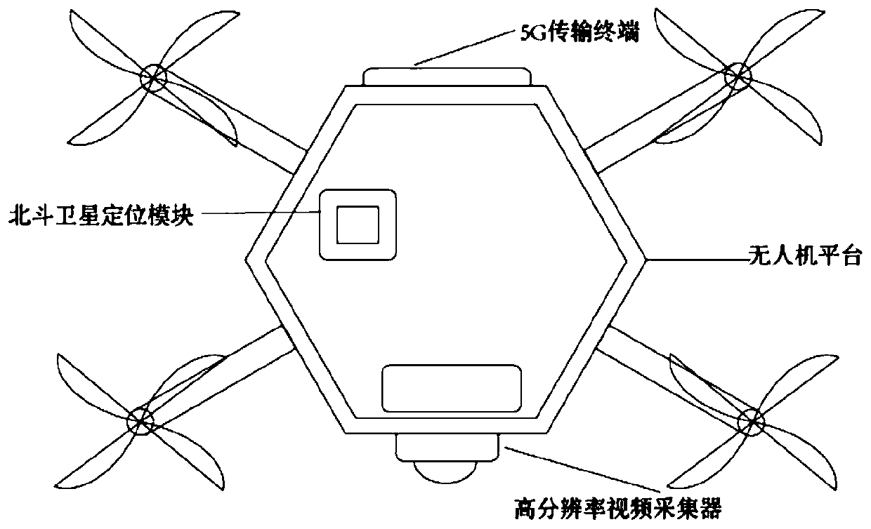
[0045] Step 1: Install Phase One iXU 180 high-resolution aerial survey camera, Huawei 5G mobile communication terminal, UFirebird UC6226 Beidou positioning chip on the low-altitude UAV to build a low-altitude UAV system;

[0046] Step 2: The low-altitude drone constructed in step 1 will cruise on the road surface to be inspected at a flight speed of 3m / s and a flight altitude of 7m, and take a high-definition photo of the road surface every 0.1 seconds. The photo is 1920×1080. Resolution, and save in JEPG format; when there are height restriction facilities on the road or terrain conditions d...


PUM


Abstract

The invention discloses a highway pavement disease positioning method based on an unmanned aerial vehicle. The unmanned aerial vehicle system is integrated with a high-resolution video collector, a 5Gmobile communication terminal and a Beidou satellite positioning navigation module; and the method comprises the steps of acquiring road surface high-resolution image data, unmanned aerial vehicle flight height data and unmanned aerial vehicle position information; based on the transmission of detection data of the 5G mobile communication technology, the pavement disease detection model based onthe improved DPM is used for detecting and positioning the pavement disease. The beneficial effects of the method are that the method effectively irons out the defects that a conventional pavement disease data obtaining method is low in automation degree, is high in obtaining cost, and is slow in speed, and a pavement disease detection and positioning method is low in detection efficiency, is large in detection precision fluctuation, is large in workload of a positioning process, and is low in positioning automation degree; and the method is high in practicability and can be widely applied topavement disease detection and positioning of highways, national roads, other low-grade highways and urban roads.

Description

Technical field [0001] The invention relates to a method for locating road pavement diseases based on drones, in particular to a method for locating road pavement diseases based on drones. Background technique [0002] 5G communication technology is the abbreviation for fifth-generation mobile communication technology. Like the 3G and 4G technologies that have been put on the market, 5G mobile communication technology is also a mobile communication technology that uses digital cellular networks. Compared with the previous cellular data communication technology, 5G communication technology has the advantage of data transmission speed and transmission capacity. Much higher than the previous cellular network. The fastest data transmission speed of commercial 5G mobile communication technology can reach 10Gbit / s, which is 100 times that of the current 4G LTE cellular network. In addition, 5G mobile communication technology also has the advantages of low network delay, fast response...

Claims


Application Information

Patent Timeline
IPC IPC(8): E01C23/01G06K9/00
CPCE01C23/01G06V20/176
Inventor 赵池航李昊袁守国张澄毛志坚郑有凤化丽茹
Owner SOUTHEAST UNIV
Why Eureka
Try Eureka