Road extraction method based on topology information refinement

A technology of road extraction and topology information, which is applied in urban planning and geographic information update, intelligent transportation, and artificial intelligence, and can solve problems such as poor inertia of road edges

Active Publication Date: 2020-03-27
中国人民解放军63729部队
View PDF2 Cites 3 Cited by
  • Summary
  • Abstract
  • Description
  • Claims
  • Application Information

AI Technical Summary

Problems solved by technology

But it didn't solve the problem ...

Method used


Image

  • Road extraction method based on topology information refinement
  • Road extraction method based on topology information refinement
  • Road extraction method based on topology information refinement

Examples


Embodiment 1

[0052] The steps that the present invention realizes are as follows:

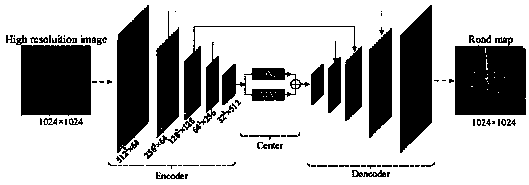
[0053] Step 1, Encoder part. Input a high-resolution remote sensing image, and the encoder encodes it into high-dimensional features of 32×32×512. The Encoder uses the pre-trained ResNet on ImageNet as the feature extractor, and the input size is adjusted to 1024×1024.

[0054] (1a) Data preprocessing. RSRE employs data augmentation to avoid the problem of overfitting without cross-validation, augmentation including flipping, vertical flipping, diagonal flipping, color dithering, image translation and scaling. In the prediction stage, each image has horizontal flip, vertical flip and diagonal flip operations. This is done using python built-in functions.

[0055] (1b) Extract high-dimensional features of the input image. The first 4 layers of the pretrained ResNet feature extractor are called and the original input 256×256 is resized to 1024×1024.

[0056] Step 2, DM increases the receptive field. In...

Embodiment 2

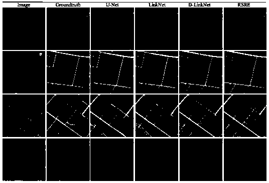
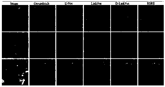
[0084] Experimental results

[0085] The effect of the RSRE of the present invention can be further illustrated by the following experiments.

[0086] 1. Experimental Conditions

[0087] The experiments use Pytorch as the deep learning framework. During the training phase, the minimum batch size is 16 and 2 GPUs are used. The learning rate was initially set to 2e-4 and decreased by a factor of 0.1 every 20 epochs.

[0088] 2. Experimental data

[0089] RSRE is tested on two large datasets. The first is the DeepGlobe Road dataset. The resolution of each image is 1024×1024. Image scenes include city, countryside, wilderness, seaside, tropical rainforest, etc. Since only the training images are labeled with GT, in order to measure the accuracy of road extraction conveniently, this experiment divides the labeled 6226 training images into 4358 for training and 1868 for testing. The second dataset is the Massachusetts Road dataset. The size is 1500×1500 and the resolution i...


PUM


Abstract

The invention relates to a road extraction method based on topological information refinement, which comprises the following specific operation steps: carrying out model training, carrying out a testprocess, and comparing the influence of the combination of different hyper-parameters or loss functions on a model. According to the invention, because the expansion module and the information moduleare fused at a pixel level in an encoding and decoding structure (encoder-decoder), a road with better edge coherence can be obtained; and meanwhile, a loss function of weight combination is applied,so that the influence of sample imbalance on the model can be controlled more effectively.

Description

technical field [0001] The invention belongs to the technical field of artificial intelligence, relates to high-resolution remote sensing image scene analysis and recognition technology, and can be used in the fields of intelligent transportation, urban planning, and geographic information updating. Background technique [0002] The purpose of high-resolution remote sensing image road extraction is to detect and segment road pixels in the image. This task classifies image pixels into two categories: roads and non-roads, and is often considered a binary classification problem. In recent years, as deep learning has made great breakthroughs in the fields of computer vision, natural language processing, and speech information processing, there are more and more methods of using deep learning to extract roads in high-resolution remote sensing images. [0003] At present, there are two main categories of methods for road extraction from high-resolution remote sensing images: [...

Claims


Application Information

Patent Timeline
IPC IPC(8): G06K9/00G06K9/62G06N3/04
CPCG06V20/182G06N3/045G06F18/241G06F18/214
Inventor 侯艳杰高家智郑向涛崔俊峰郝云胜商临峰杨晓骞夏霏张香成高燕
Owner 中国人民解放军63729部队
Why Eureka
Try Eureka