
Multi-beam radar for ground-like flight control of unmanned aerial vehicle and data fusion method

A flight control and data fusion technology, applied in the field of radar detection, can solve the problem that the ground imitation millimeter wave radar cannot know the terrain changes in the forward direction in advance, and achieve the effects of significant economic and social benefits, low system delay, and simple installation.

Inactive Publication Date: 2020-03-31
湖南纳雷科技有限公司
View PDF12 Cites 1 Cited by
  • Summary
  • Abstract
  • Description
  • Claims
  • Application Information

AI Technical Summary

Problems solved by technology

[0005] The present invention provides a multi-beam radar and a data fusion method used for ground-following flight control of UAVs to solve the technical problem that the existing ground-following millimeter-wave radar cannot know the terrain changes in the forward direction in advance

Method used


Image

  • Multi-beam radar for ground-like flight control of unmanned aerial vehicle and data fusion method
  • Multi-beam radar for ground-like flight control of unmanned aerial vehicle and data fusion method

Examples


Embodiment Construction

[0028] The embodiments of the present invention will be described in detail below with reference to the accompanying drawings, but the present invention can be implemented in many different ways defined and covered by the claims.

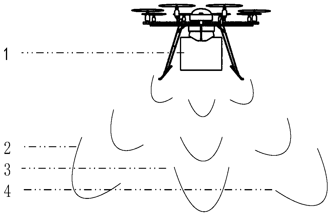
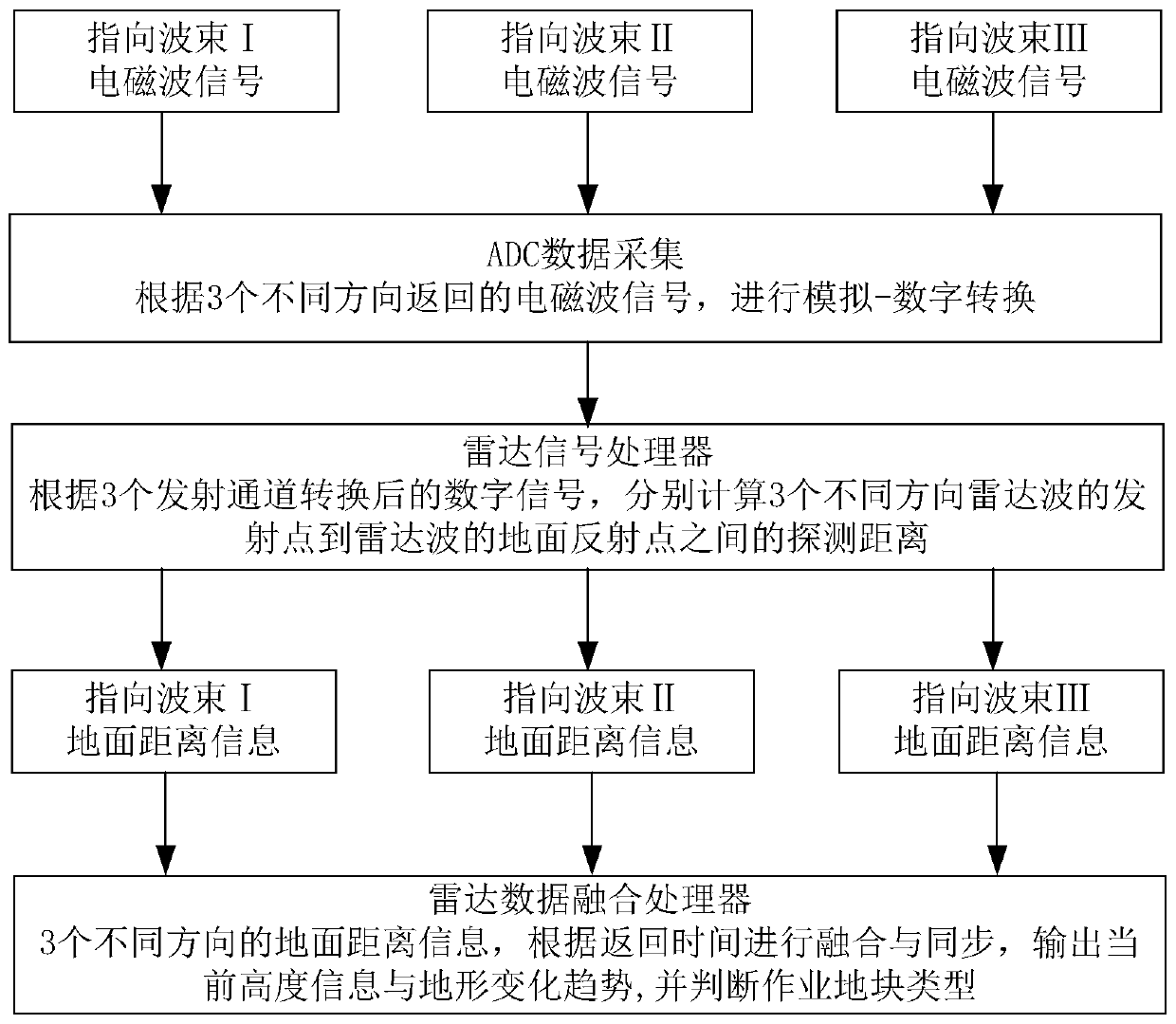
[0029] see figure 1 , the multi-beam radar 1 that is used for unmanned aerial vehicle imitation flight control of the present invention comprises: radar antenna, radar radio frequency front-end, radar signal processor and data fusion processor; Radar antenna comprises at least three channels (this embodiment Among them are three: respectively figure 1 Microstrip array transmitting antennas pointing to beam I2, beam II3, and beam III4) and receiving antennas with at least two channels (preferably four channels in this embodiment); the radar RF front-end passes through at least three The microstrip array transmitting antenna of one channel transmits electromagnetic waves to at least three different directions; the reflected wave after the electromagn...


PUM


Abstract

The invention discloses a multi-beam radar for ground-like flight control of an unmanned aerial vehicle and a data fusion method. The radar comprises a radar antenna, a radar radio frequency front end, a radar signal processor, a data fusion processor, a radar antenna, a microstrip array transmitting antenna comprising at least three channels and having different wave beam orientations, and receiving antennas of at least two channels. The radar radio frequency front end transmits electromagnetic waves to at least three different directions through microstrip array transmitting antennas of at least three channels. Reflected waves after electromagnetic waves meet obstacles and are reflected are received by the receiving antennas of the at least two channels, processed by the radar signal processor respectively and fused into topographic information by the data fusion processor. The multi-beam radar antenna is adopted, the height information of the ground under the front position and in the heading forward direction and the heading backward direction can be detected at the same time, the single radar can output ground distance information in different directions at the same time, andthen the type of an operation plot is judged.

Description

technical field [0001] The invention relates to the technical field of radar detection, in particular to a multi-beam radar and a data fusion method used for ground imitation flight control of an unmanned aerial vehicle. Background technique [0002] The UAV needs to know the current accurate height information during the flight operation. For example, when the plant protection UAV is spraying pesticides, the distance between the UAV and the vegetation will directly affect the effect of pesticide spraying. At present, millimeter-wave radar products are mostly used for the fixed-altitude flight of UAV operations, which can measure the vertical distance between the UAV and the ground, and have achieved good application results in flat operating terrain scenarios. However, in the face of complex terrain such as hilly areas, mountains, and terraced fields, in order to meet the high-precision requirements of the millimeter-wave ground-imitation radar, it is necessary to design a ...

Claims


Application Information

Patent Timeline
IPC IPC(8): G01S13/933G06K9/62
CPCG06F18/251
Inventor 谭俊杰易浩周坤明彭佳钟仁海赵欣
Owner 湖南纳雷科技有限公司
Learn More