Forecasting method and forecasting system for dust-haze and sand-dust weather
A haze and dust technology, applied in the field of haze and dust weather forecasting methods and systems, can solve the problem that the observation network density cannot meet the forecast requirements, restrict the accuracy of haze and sand dust weather forecast, and prevent haze and dust weather Sand and dust weather prevention and response
- Summary
- Abstract
- Description
- Claims
- Application Information
AI Technical Summary
Problems solved by technology
Method used
Image
Examples
Embodiment 1
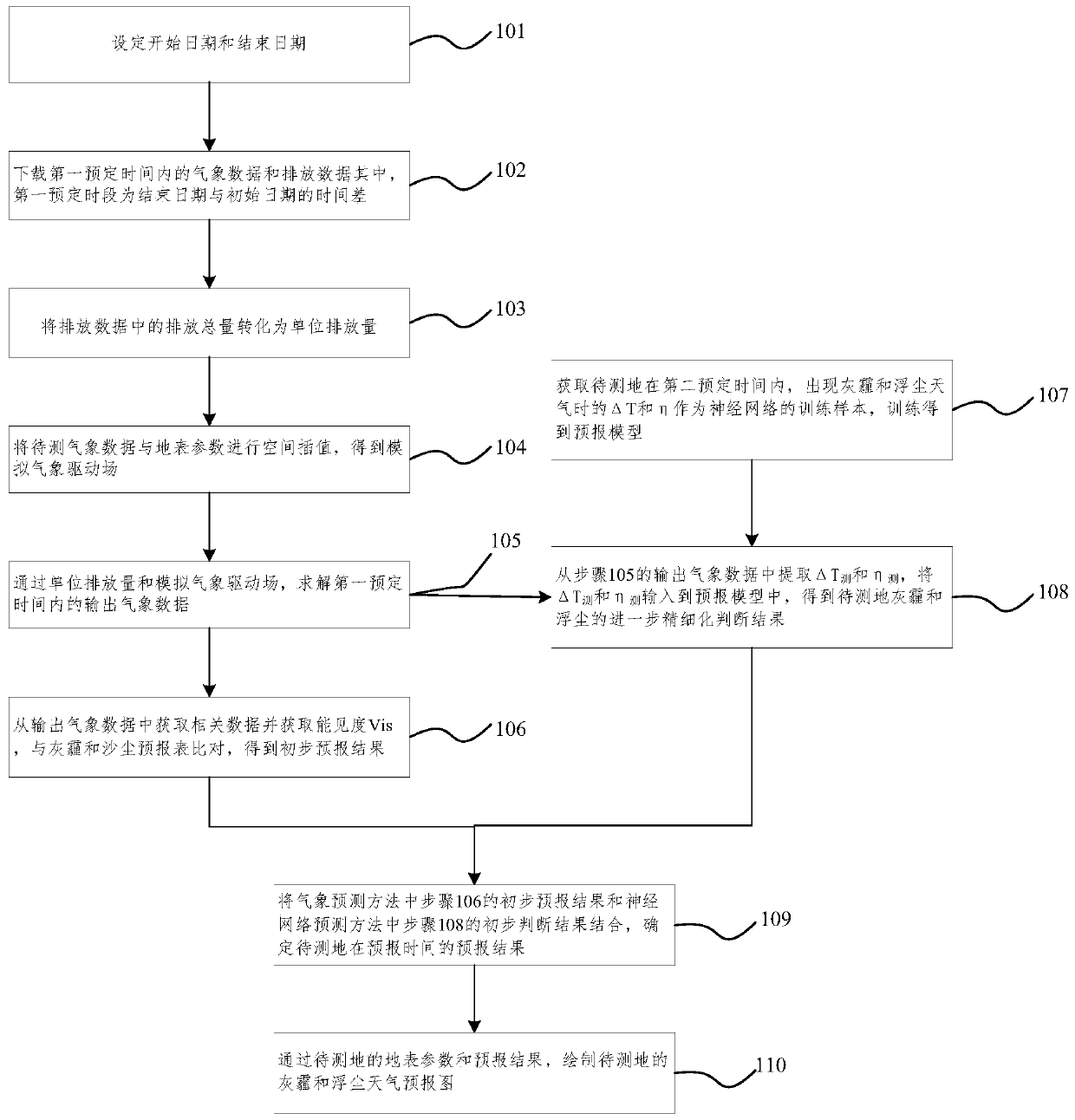
[0075] Such as figure 1 Shown, the first embodiment of the method for forecasting haze and dust weather of the present invention, this method comprises: Meteorological forecasting method and neural network forecasting method;
[0076] Among them, weather forecasting methods include:
[0077] 101. Set a start date and an end date. Specifically, use the Bash shell script to set the start date of the forecast. By default, the computer system time is automatically obtained, or it can be set manually. The start date is assigned as DATE_START, and the year, month, and day corresponding to the time are assigned values To YY_S, MM_S, DD_S.
[0078] According to the start date of the forecast, the Bash shell script automatically sets the date three days later as the end date of the forecast. The end date can also be set manually, and the end date is assigned as DATE_END, which is the same as the assignment of the start date. , month, and day are assigned to YY_E, MM_E, and MM_E resp...
Embodiment 2
[0130] Such as Figure 4 Shown, the first implementation of the forecast system of haze and dust weather of the present invention, this system comprises:
[0131] The data downloading module is used to download meteorological data and discharge data in the first predetermined period, wherein, the first predetermined period is the time difference between the end date and the initial date; in the present embodiment, the data download tool is wget in the Bash shell script The tool, in which the meteorological data is the global weather forecast reanalysis data with a geographical resolution of 0.25°×0.25° provided by the Global Forecast System (GFS) of the National Environmental Forecasting Center of the United States; the emission data is the emission data for global atmospheric research. The database (Emission Database for Global Atmospheric Research, EDGAR) provides reanalysis data of atmospheric pollutant emissions on a global scale with a geographic resolution of 0.1°×0.1°. ...
PUM
 Abstract
Description
Claims
Application Information
 - R&D
- Intellectual Property
- Life Sciences
- Materials
- Tech Scout
- Unparalleled Data Quality
- Higher Quality Content
- 60% Fewer Hallucinations
Browse by: Latest US Patents, China's latest patents, Technical Efficacy Thesaurus, Application Domain, Technology Topic, Popular Technical Reports.
© 2025 PatSnap. All rights reserved.Legal|Privacy policy|Modern Slavery Act Transparency Statement|Sitemap|About US| Contact US: help@patsnap.com


