Efficient three-dimensional remote sensing satellite formation method

A technology for remote sensing satellites and satellites, which is applied to artificial satellites, space navigation equipment, space navigation equipment, etc., can solve the problems of weight, large volume, inability to image, and high cost of attitude control components of three-line array stereo imaging camera satellites. The effect of task reliability, reduced R&D cost, and simple control logic

A technology for remote sensing satellites and satellites, which is applied to artificial satellites, space navigation equipment, space navigation equipment, etc., can solve the problems of weight, large volume, inability to image, and high cost of attitude control components of three-line array stereo imaging camera satellites. The effect of task reliability, reduced R&D cost, and simple control logic

CN111017264AActive Publication Date: 2020-04-17CHINA ACADEMY OF SPACE TECHNOLOGY

Image

  • Efficient three-dimensional remote sensing satellite formation method
  • Efficient three-dimensional remote sensing satellite formation method
  • Efficient three-dimensional remote sensing satellite formation method

Examples


Embodiment Construction

[0032] In order to make the object, technical solution and advantages of the present invention clearer, the implementation manner of the present invention will be further described in detail below in conjunction with the accompanying drawings.

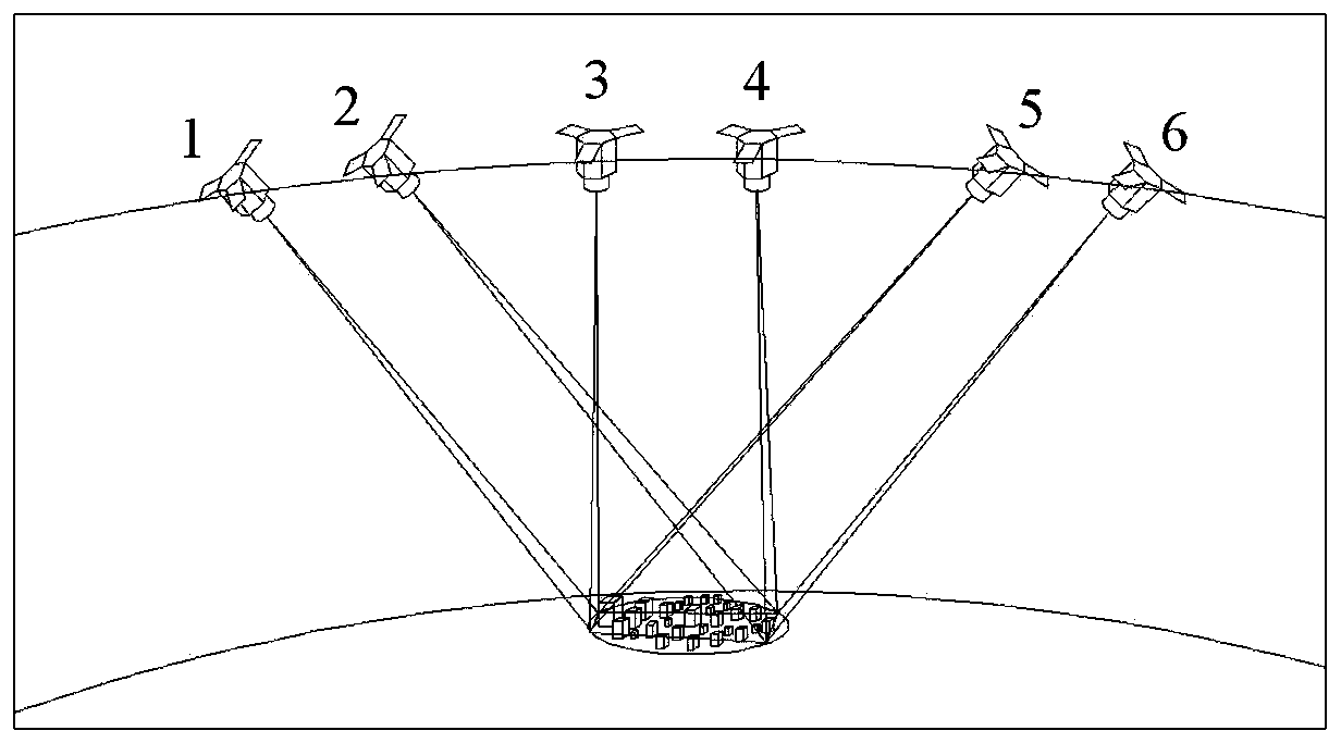
[0033] Stereo imaging mode of agile remote sensing satellite such as figure 1 As shown, when the agile remote sensing satellite passes over a certain city on a single track, it will maintain its attitude towards the ground in the 1-2 arc, 3-4 arc, and 5-6 arc respectively. Perform attitude maneuver adjustments and establish a stable attitude in arcs 2-3 and 4-5.

[0034] Due to the limitation of the length of imaging strips in the single-track stereo imaging task of agile satellites, the reason is that figure 1 During the working process of the stereoscopic imaging shown, the attitude adjustment of the satellite in the 2-3 arc and 4-5 arc has a certain "rigid" time requirement, which depends on the satellite's attitude maneuverability...


PUM


Abstract

The invention discloses an efficient three-dimensional remote sensing satellite formation method, which is characterized in that a plurality of space cameras required by three-dimensional imaging arerespectively mounted on a plurality of satellites, each satellite can independently carry out attitude control, and the plurality of satellites can conduct observation from different directions of a target through mutual cooperation of the attitude control. Each satellite can carry out long-time large-strip scanning imaging, and large-angle attitude maneuver is not needed in the three-dimensionalimaging process. The effective working time proportion of each satellite can be increased to nearly 100%.

Description

technical field [0001] The present invention relates to an efficient three-dimensional remote sensing satellite formation method, in particular to a satellite formation method for realizing efficient three-dimensional remote sensing on the global surface. According to the terrain characteristics of urban areas, it can efficiently produce high positioning accuracy "no occlusion, no shadow" "Digital Stereo Remote Sensing Products. Background technique [0002] The requirements for digital remote sensing products in the field of modern urban planning are getting higher and higher. Compared with aerial remote sensing, satellite remote sensing technology has the advantages of large range and high efficiency. Spatial three-dimensional remote sensing technology is an emerging technical field in recent years. It obtains the plane dimension and elevation dimension information of buildings in the target area by scanning multiple strips from different directions over the target area. ...

Claims


Application Information

Patent Timeline
17 Apr 2020
Publication
CN111017264A
IPC
B64G1/24; B64G1/10
CPC
B64G1/24; B64G1/1085; B64G1/245
Inventors
满益云; 张嘉雷