SUMO traffic simulation scene accurate construction method based on data conversion

A traffic simulation and construction method technology, which is applied in the field of traffic simulation, can solve problems such as wrong topological structure of the simulated road network, heavy manual modeling workload, etc., and achieve the effects of high processing efficiency, rich data, and real and accurate scenes

Pending Publication Date: 2020-04-17
SUN YAT SEN UNIV
View PDF0 Cites 7 Cited by
  • Summary
  • Abstract
  • Description
  • Claims
  • Application Information

AI Technical Summary

Problems solved by technology

[0003] In order to solve the problems of the existing SUMO in the modeling application due to the complex data format, the simulation road network topology structure error, and the manual modeling workload are relatively large, a method for accurately constructing SUMO traffic simulation scenes based on data conversion is provided.

Method used


Image

  • SUMO traffic simulation scene accurate construction method based on data conversion
  • SUMO traffic simulation scene accurate construction method based on data conversion
  • SUMO traffic simulation scene accurate construction method based on data conversion

Examples


Embodiment 1

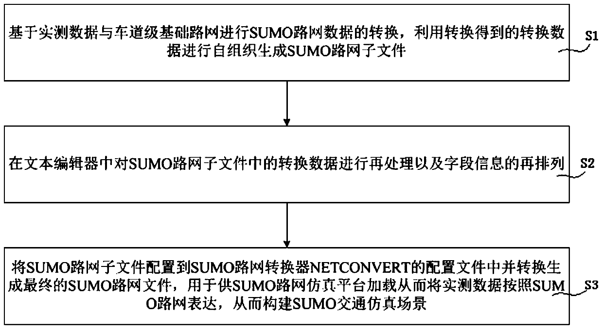
[0052] A method for accurately constructing SUMO traffic simulation scenarios based on data conversion, such as figure 1 shown, including the following steps:

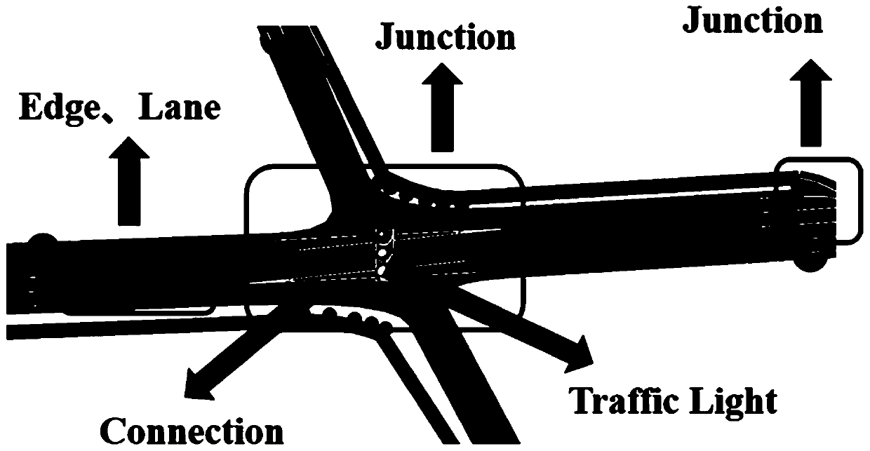
[0053] S1. Convert the SUMO road network data based on the measured road network data and the lane-level basic road network, and use the converted data to self-organize and generate SUMO road network sub-files; among them, in the SUMO road network, such as figure 2 As shown, the edge is used to describe the road section, the junction is used to describe the nodes of the road network, and the connection is used to describe the connection relationship between road sections and lanes; self-organized generated SUMO road network sub-files include *.nod.xml, *.edg.xml, *. typ.xml, *.con.xml;

[0054] In this step, the conversion of SUMO road network data based on the measured road network data and the lane-level basic road network is specifically: according to the data of the node Nodes file, the edge Edges file, the road ...

Embodiment 2

[0082] In this embodiment 2, based on the accurate construction method of SUMO traffic simulation scene provided in embodiment 1, the basic simulation scene is accurately constructed and applied at the two intersections in Xuancheng, Anhui.

[0083] 1. Based on the measured road network data and the lane-level basic road network, the corresponding data conversion is performed according to the method of the above-mentioned embodiment 1, and the SUMO road network sub-file conversion is constructed to obtain Xuancheng H84 (Aofeng Road and Zhuangyuan Road), H91 ( Basic road network at the intersection of Aofeng Road and Lingxi Road;

[0084] 2. Based on the measured traffic passing data at the checkpoint and the vehicle route set data, import and load the current traffic flow data of the day on August 30, 2018 to the created basic road network of the intersection;

[0085] 3. Based on the measured checkpoint dynamic signal control data and additional facility data, load the comple...

Embodiment 3

[0087] In this embodiment 3, based on the accurate construction method of SUMO traffic simulation scene provided in embodiment 1, the precise construction and application of the basic simulation scene of the Guanzhou Tunnel intersection in the university town is carried out.

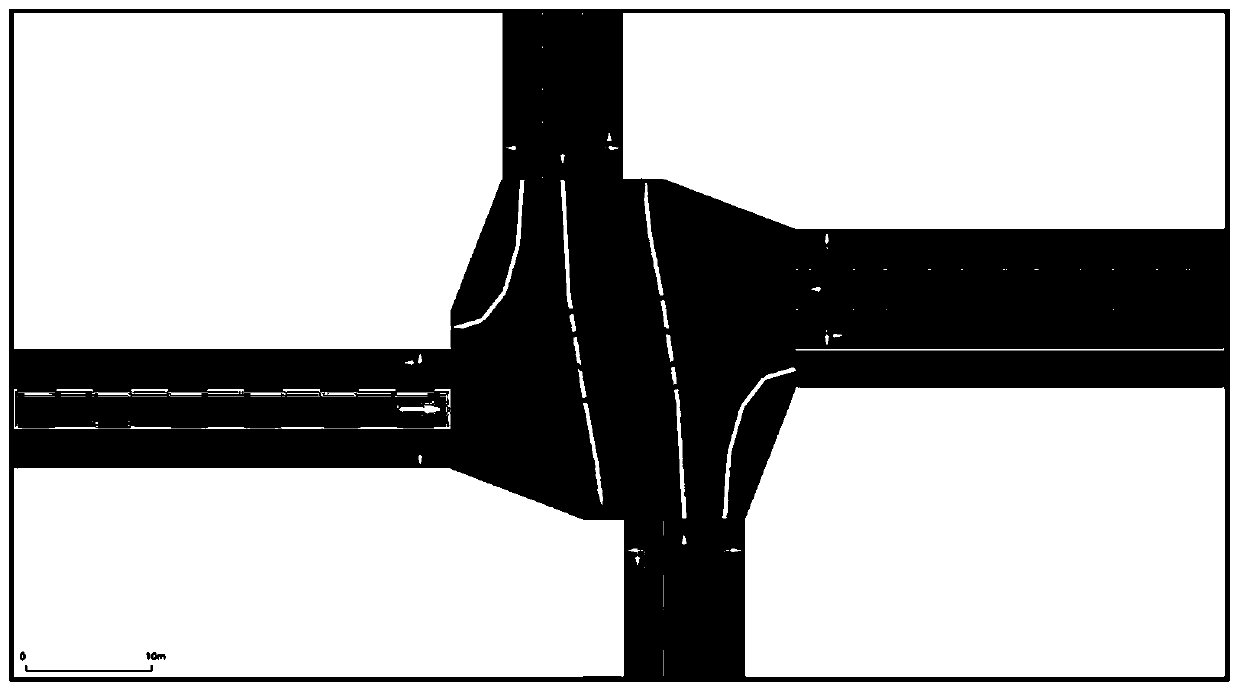
[0088] 1. Based on the measured road network data and the lane-level basic road network, build the basic road network model of the Guanzhou Tunnel intersection.

[0089] The basic topological structure of the road network: three lanes for entrance and five lanes for exit in the direction of Zhonghuan East Road; three lanes for entrance and three lanes for exit in the direction of Zhonghuan West Road, and one right-turn lane; two lanes for entrance and one right-turn lane in the direction of Central North Street, There are two lanes at the exit; the Guanzhou Tunnel has two one-way and two-way lanes. The simulation scene effect of Guanzhou Tunnel intersection obtained after data conversion is as follows: ...


PUM


Abstract

The invention discloses an SUMO traffic simulation scene accurate construction method based on data conversion. The method is based on existing actual measurement road network data and a lane level road network model. Data conversion, self-organization and reprocessing are carried out on basic object element information forming SUMO road network sub-files, a relevant conversion tool is combined, effective and available SUMO road network files are created and generated and used for SUMO simulation, and therefore accurate construction and control of a simulation scene are achieved. According tothe method, the problems of road network topological structure errors, low execution efficiency and the like caused by complex data formats and complex workloads after conversion processing are solved.

Description

technical field [0001] The invention relates to the technical field of traffic simulation, in particular to a method for accurately constructing a SUMO traffic simulation scene based on data conversion. Background technique [0002] As an open-source microscopic traffic simulation software, SUMO can support external data in multiple formats because of its scalability and high compatibility. However, the following problems exist in the construction of traffic simulation scenes by applying it at present: 1. Different types of external road network data such as OSM map data, VISSIM, MATSim, etc. have various object elements, which are relatively complex, and further editing is still required after direct import and conversion. Processing, for large-scale and complex simulated road networks, the workload is heavy and very complicated; 2. Due to the limitations and constraints of external data sources, formats, and naming rules, the imported data types cannot well meet the person...

Claims


Application Information

Patent Timeline
Patent Type & Authority Applications(China)
IPC IPC(8): G06F30/18G08G1/01
CPCG08G1/0125
Inventor 何兆成徐昕宇陈锐祥
Owner SUN YAT SEN UNIV
Why Eureka
Try Eureka