Three-dimensional live-action modeling method based on aerial survey of unmanned aerial vehicle

A real scene modeling and unmanned aerial vehicle technology, applied in 3D modeling, image data processing, special data processing applications, etc., can solve the problems of effective control of unfavorable construction period, insufficient precision of modeling model, long modeling sequence, etc. Achieve the effect of reducing measurement cost, improving measurement efficiency and low cost

Pending Publication Date: 2020-05-01
THE SIXTH CONSTR CO LTD OF CHINA NAT CHEM ENG
View PDF5 Cites 24 Cited by
  • Summary
  • Abstract
  • Description
  • Claims
  • Application Information

AI Technical Summary

Problems solved by technology

[0003] In the field of traditional engineering construction, when performing 3D modeling of buildings, manual measurement is usually used, and then manual sketch drawing and model rendering are performed on the 3D modeling software. The modeling time sequence is long, the process is complicated, and manual measurement and drawing It is easy to cause serious problems

Method used


Image

  • Three-dimensional live-action modeling method based on aerial survey of unmanned aerial vehicle

Examples


Embodiment Construction

[0036] The present invention will be further described in detail below in conjunction with the accompanying drawings, so that those skilled in the art can implement it with reference to the description.

[0037] It should be noted that, in the description of the present invention, the terms "horizontal", "vertical", "upper", "lower", "front", "rear", "left", "right", "vertical", The orientation or positional relationship indicated by "horizontal", "top", "bottom", "inner", "outer", etc. is based on the orientation or positional relationship shown in the drawings, and is only for the convenience of describing the present invention and simplifying the description, and It is not to indicate or imply that the device or element referred to must have a particular orientation, be constructed or operate in a particular orientation, and thus should not be construed as limiting the invention.

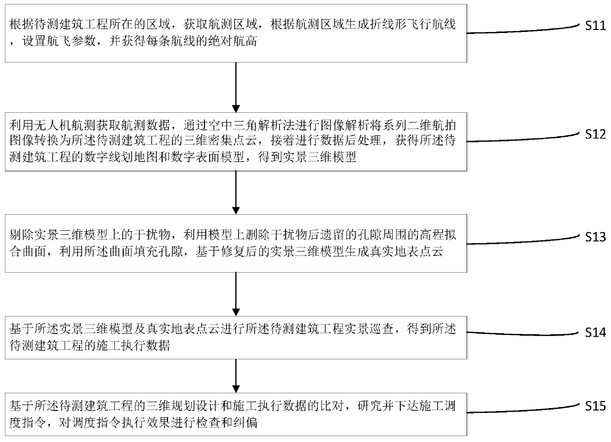
[0038] Such as figure 1 As shown, the 3D real scene modeling method based on UAV aerial surv...


PUM


Abstract

The invention discloses a three-dimensional real scene modeling method based on aerial survey of an unmanned aerial vehicle. The three-dimensional live-action modeling method based on aerial survey ofthe unmanned aerial vehicle comprises the following steps that 1, three-dimensional live-action modeling is carried out, aerial survey data are obtained through aerial survey of an unmanned aerial vehicle, image analysis is conducted through an aerial triangular analysis method, a series of two-dimensional aerial images are converted into three-dimensional dense point clouds of the to-be-measuredconstructional engineering, then data post-processing is conducted, a digital line drawing map and a digital surface model of the to-be-measured constructional engineering are obtained, and a live-action three-dimensional model is obtained; performing live-action patrol of the to-be-tested constructional engineering based on the live-action three-dimensional model and real surface point cloud toobtain construction execution data of the to-be-tested constructional engineering; and based on comparison of the three-dimensional planning design and construction execution data of the to-be-testedconstructional engineering, researching and issuing a construction scheduling instruction, and checking and correcting the execution effect of the scheduling instruction. The three-dimensional real scene modeling method based on aerial survey of the unmanned aerial vehicle is high in efficiency and low in cost.

Description

technical field [0001] The present invention relates to the technical field of architectural design, and more specifically, the present invention relates to a three-dimensional real-scene modeling method based on unmanned aerial vehicle aerial survey. Background technique [0002] Three-dimensional GIS (Geographic Information System, Geographic Information System) is one of the main symbolic contents of GIS technology today and even in the future. Provides more effective auxiliary decision support. For the construction industry and surveying and mapping, scalable 3D models are essential. [0003] In the field of traditional engineering construction, when performing 3D modeling of buildings, manual measurement is usually used, and then manual sketching and model rendering are performed on the 3D modeling software. The modeling time sequence is long, the process is complicated, and manual measurement and drawing It is easy to cause serious problems such as insufficient preci...

Claims


Application Information

Patent Timeline
IPC IPC(8): G06T17/00G06T17/05G06F16/29
CPCG06T17/00G06T17/05G06F16/29
Inventor 汪建波方伟王伟闵泽斐沈泽熊晴雪谢辉高放
Owner THE SIXTH CONSTR CO LTD OF CHINA NAT CHEM ENG
Why Eureka
Try Eureka