
Massive urban space three-dimensional data cloud rendering image fusion method and system

An image fusion and three-dimensional data technology, applied in image data processing, 3D image processing, instruments, etc., can solve the problems of slow image fusion process and affecting rendering performance, and achieve the effect of improving efficiency

Active Publication Date: 2020-05-12
深圳市数字城市工程研究中心 +1
View PDF4 Cites 2 Cited by
  • Summary
  • Abstract
  • Description
  • Claims
  • Application Information

AI Technical Summary

Problems solved by technology

And as the size of the 3D model gradually increases, the number of nodes required will also increase, and the image fusion process will become slower and slower, further affecting rendering performance

Method used


Image

  • Massive urban space three-dimensional data cloud rendering image fusion method and system
  • Massive urban space three-dimensional data cloud rendering image fusion method and system
  • Massive urban space three-dimensional data cloud rendering image fusion method and system

Examples


Embodiment Construction

[0049] In order to make the object, technical solution and advantages of the present invention clearer, the present invention will be further described in detail below in conjunction with the accompanying drawings and specific embodiments. It should be understood that the specific embodiments described here are only used to explain the present invention, not to limit the present invention.

[0050] In the following text, many aspects of the invention will be better understood with reference to the accompanying drawings. Components in the figures are not necessarily drawn to scale. Instead, emphasis is placed on clearly illustrating the components of the invention. Furthermore, like reference numerals indicate corresponding parts throughout the several views of the drawings.

[0051] As used herein, the word "exemplary" or "illustrative" means serving as an example, instance, or illustration. Any implementation described herein as "exemplary" or "illustrative" is not necessari...


PUM


Abstract

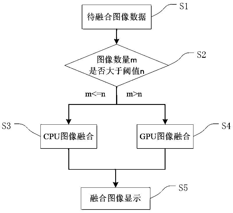
The invention relates to the field of massive urban space three-dimensional data cloud rendering, in particular to a massive urban space three-dimensional data cloud rendering image fusion method anda massive urban space three-dimensional data cloud rendering image fusion system. The method is characterized by comprising the following steps of: S1, acquiring image data to be fused; S2, judging the number of images; S3, carrying out CPU image fusion; S4, carrying out GPU image fusion; and S5, completing the image fusion. According to the invention, the fusion efficiency of multiple images canbe greatly improved, and the rendering performance of a three-dimensional large-scale scene is further improved.

Description

technical field [0001] The invention relates to the field of cloud rendering of massive urban space three-dimensional data, in particular to a method and system for fusion of massive urban space three-dimensional data cloud rendering images. Background technique [0002] High-precision, high-resolution three-dimensional data extraction of urban space is the key to "smart cities" and "digital cities". Due to the lack of means, the urban three-dimensional spatial data is leaping exponentially. [0003] The three-dimensional data of urban space mainly includes the data obtained by combining two-dimensional maps and architectural design drawings, digital photogrammetry, laser scanning systems, high-resolution satellite remote sensing, and vehicle-mounted mobile surveying and mapping systems. The combination of two-dimensional maps and architectural design drawings refers to the combination of map data that can meet the contour accuracy requirements and building planning and des...

Claims


Application Information

Patent Timeline
IPC IPC(8): G06T15/20G06T1/20
CPCG06T15/205G06T1/20
Inventor 王瑜万波王鹏左泽均胡茂胜钱颢月甄文杰潘明敏
Owner 深圳市数字城市工程研究中心
Learn More