Slope length extraction method based on SRTM

An extraction method and technology of slope length, applied in the field of digital terrain analysis, can solve problems such as inability to directly extract slope length, avoid format conversion and coordinate transformation process, improve extraction efficiency, and avoid loss of accuracy

Active Publication Date: 2020-05-19
NORTHWEST A & F UNIV
View PDF2 Cites 6 Cited by
  • Summary
  • Abstract
  • Description
  • Claims
  • Application Information

AI Technical Summary

Problems solved by technology

[0005] In view of the deficiencies in the prior art, the purpose of the present invention is to provide a method for extracting slope le...

Method used


Image

  • Slope length extraction method based on SRTM
  • Slope length extraction method based on SRTM
  • Slope length extraction method based on SRTM

Examples


Embodiment 1

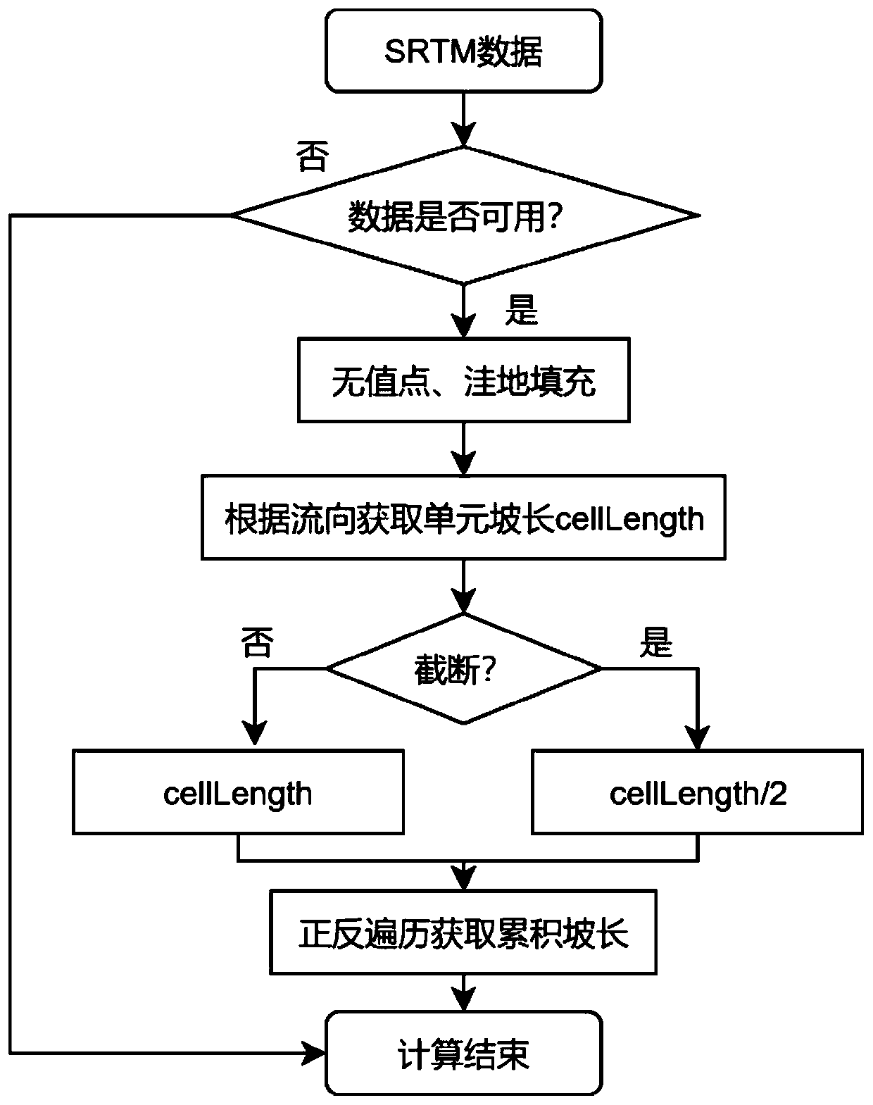
[0070] This embodiment provides a method for extracting slope length based on SRTM, and the specific process is divided into the following steps:

[0071] Step 1: Store the value of the header information cellsize of the SRTM data, and at the same time obtain the slope value and flow direction of each grid in the SRTM data. Specifically include:

[0072] 1.1 Data Input

[0073] (1) Read data header information: Create a structure, read all header information of SRTM data by row, and store them in the corresponding attributes of the structure.

[0074] (2) Read SRTM elevation data. Store the elevation data converted into float type into the elevation data matrix. For the convenience of calculation and to ensure the consistency of the surrounding grids of each data, the data is expanded by two circles, so the data is put into a matrix expanded by two circles used for calculations.

[0075] 1.2: No value point, depression filling.

[0076] 1.3: Traverse the two-dimensional a...


PUM


Abstract

The invention provides a slope length extraction method based on an SRTM. The method comprises the steps: building a grid model under geographic coordinates, and directly deducing a calculation mode of the side length of an SRTM grid from the grid model; when the slope length is calculated, the influence of slope truncation and river network truncation is considered, the result meets the actual situation as much as possible, and finally the accumulated slope length of the SRTM is calculated through forward and reverse traversal. Compared with a traditional method, the method has the advantagesthat projection coordinate transformation is not needed any more, and therefore the slope length extraction efficiency is improved; meanwhile, it can be guaranteed that the precision of original datais not reduced, the slope length extraction result is relatively accurate, the slope length result is compared with an existing DEM calculation result to be displayed, the slope length difference value range is centralized, and regularity is achieved.

Description

technical field [0001] The invention relates to a digital terrain analysis technology intersected by erosion, geography, and computer science, in particular to an SRTM-based slope length extraction method, and designs and implements a slope length extraction method based on SRTM geographic coordinates. Background technique [0002] Slope length is an important factor affecting soil and water conservation and soil erosion research. In USLE, slope length is defined as the horizontal distance from the start of overland flow to the cutoff of runoff or interruption of flow path. It is terminated (cut off) in the following two situations: (1) when the slope becomes gentle so that sedimentation occurs, it is called slope cutoff (Slope Cutoff Factor, SCF); (2) where there is an obvious river network, it is called river network cutoff factor (Chanel Networks Cutoff Factor CNCF). At the slope scale, usually the slope and slope length can be actually measured. In watershed or region...

Claims


Application Information

Patent Timeline
IPC IPC(8): G06F30/20
Inventor 张宏鸣杨勤科常毅张国良孙红光张凡许伊昆董良张泉
Owner NORTHWEST A & F UNIV
Why Eureka
Try Eureka