City reachable area searching system and method

An area search and city technology, applied in the field of city reachable area search system, can solve problems such as low algorithm efficiency, failure to give target area reachability probability, different road traffic conditions, etc., to alleviate repeated calculations and make search results reasonable , the effect of accurate search results

Active Publication Date: 2020-06-02
XI AN JIAOTONG UNIV +1
View PDF5 Cites 0 Cited by
  • Summary
  • Abstract
  • Description
  • Claims
  • Application Information

AI Technical Summary

Problems solved by technology

[0009] This method has three main disadvantages: (1) It uses spatial distance for area search, but users usually pay more attention to travel time
(2) It ignores the impact of the search time on the query results. Generally speaking, the traffic conditions of roads at different times are obviously different
(3) The algorithm is inefficient for large-scale urban road networks and vehicle trajectory algorithms
(4) The reachability probability of the target area cannot be given

Method used


Image

  • City reachable area searching system and method
  • City reachable area searching system and method
  • City reachable area searching system and method

Examples


Embodiment

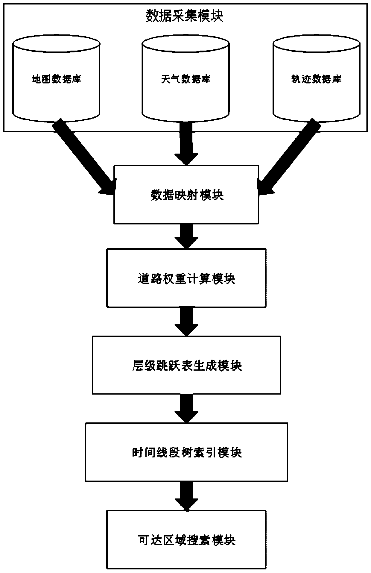
[0063] figure 1 As shown, the urban reachable area search system of this embodiment includes a data acquisition module, a data mapping module, a road weight calculation module, a hierarchical jump table generation module, a timeline segment tree index module, and a reachable area search module: the city of this embodiment The reachable area search method includes the following steps:

[0064] Step 1: The data acquisition module obtains map network data and trajectory data from the map database and the trajectory database. The map network data refers to the road network data of the city, which includes nodes representing intersections and edges representing road segments, and the trajectory data is composed of consecutive GPS points with time stamps.

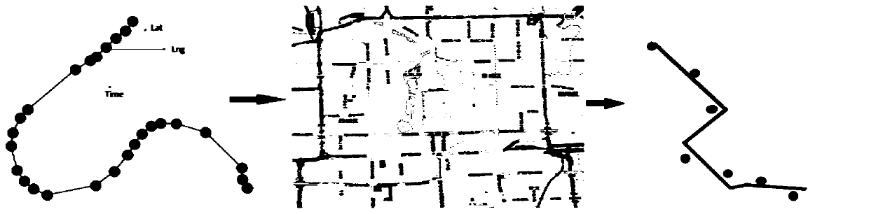
[0065] Step 2: The data mapping module uses the map matching method to map the trajectory data to the road network, and obtains the historical trajectory corresponding to each urban road.

[0066] like figure 2 shown, figur...


PUM


Abstract

The invention discloses a city reachable area searching system and method. The method comprises the steps of obtaining map network data and track data; correlating the road with the track; calculatinga mean value and a variance of the road segment speed; mapping the probability of search input into a corresponding speed by utilizing the mean value, the variance and a road speed distribution function, and calculating the time weight of the road section; according to the time weight of the road segment at the preset moment and the road network data, calculating an area set which can be reachedfrom a certain place within a preset interval at the preset moment, and generating a hierarchical jump table; establishing a query index for the hierarchy jump table, and obtaining road information according to the query index to obtain an urban reachable area; and performing iterative search in the road network by using the time line segment tree index, and finally outputting a reachable area set. According to the method, the problem that the reachable area in the spatial network can be quickly found from the given position within the given time under the condition of massive multi-source heterogeneous data is solved.

Description

technical field [0001] The invention belongs to the technical field of data mining, and relates to an accessible area search method in the field of urban computing, in particular to a search system and method for an urban accessible area. Background technique [0002] In recent years, with the rapid development of smart cities, the concept of urban computing was proposed and soon received great attention. Space-time reachable region search is an innovative problem in urban computing, which aims to find reachable regions in a spatial network from a given location within a given time. This problem requires the use of multi-source data such as urban road network data, taxi trajectory data, etc. We need to conduct reasonable analysis and processing of these multi-source data to solve this extremely challenging and innovative problem in urban computing. [0003] Existing search methods for reachable areas usually use a distance-based search method in the road network. The searc...

Claims


Application Information

Patent Timeline
Patent Type & Authority Applications(China)
IPC IPC(8): G06F16/9537G06Q50/26
CPCG06F16/9537G06Q50/26
Inventor 孙鹤立张优优杨洲何亮黄健斌陈积银贾晓琳
Owner XI AN JIAOTONG UNIV
Why Eureka
Try Eureka