Clustering storage method for airborne navigation data

A technology for navigating data and data, applied in database indexing, structured data retrieval, special data processing applications, etc. The effect of improving reading efficiency and data continuity

Pending Publication Date: 2020-06-09
航科院中宇(北京)新技术发展有限公司
View PDF4 Cites 4 Cited by
  • Summary
  • Abstract
  • Description
  • Claims
  • Application Information

AI Technical Summary

Problems solved by technology

If the data storage method is not optimized, the computing efficiency and real-time performance of the overall system will be affected

Method used


Image

  • Clustering storage method for airborne navigation data
  • Clustering storage method for airborne navigation data
  • Clustering storage method for airborne navigation data

Examples


Embodiment 1

[0033] A cluster storage method for airborne navigation data, the method steps are as follows:

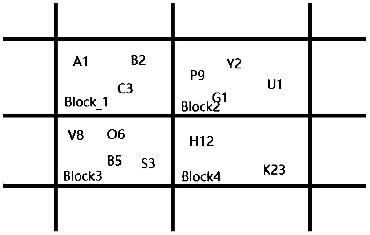
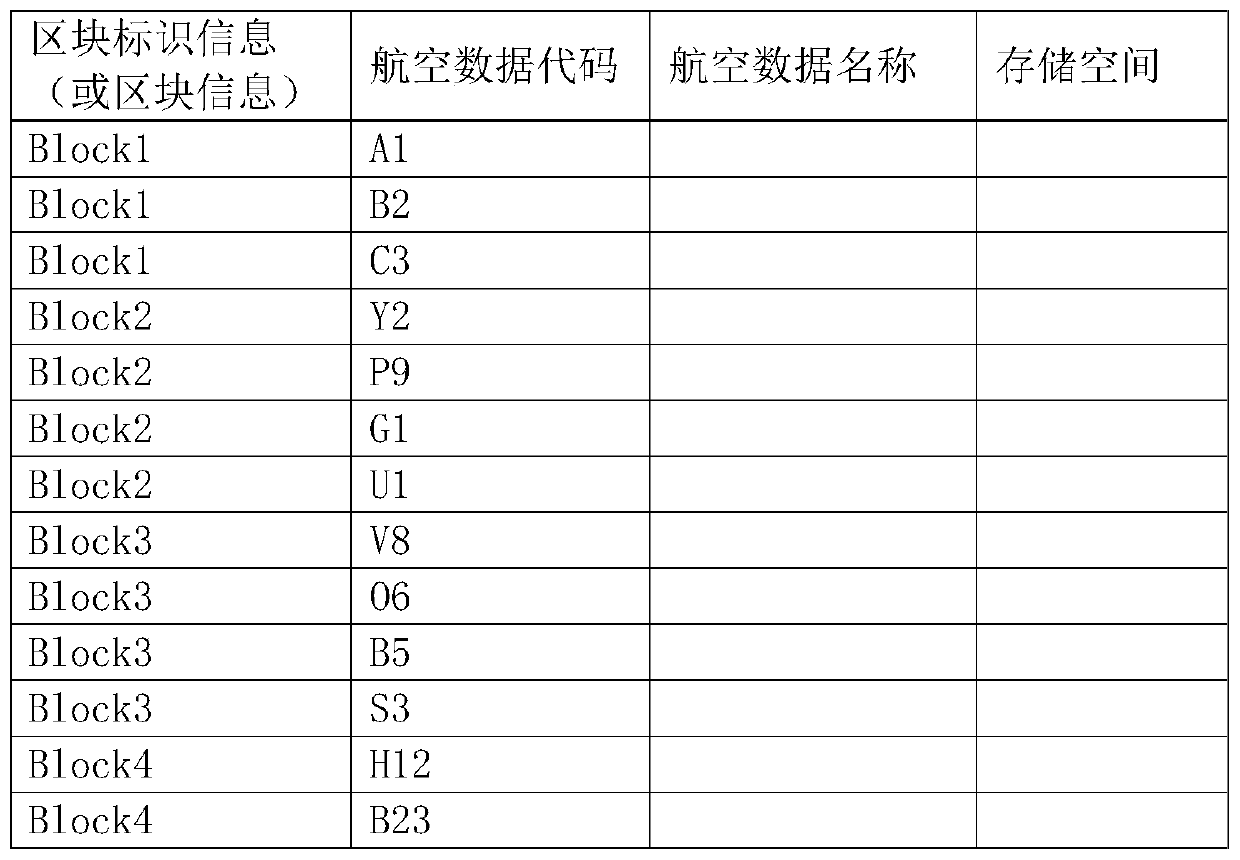
[0034] A. In the geographical coordinate system, successive blocks are divided successively, and the longitude and latitude coordinate positions of the aviation data are collected from the airborne navigation data. The aviation data includes waypoint data, navigation station data, airport data, and runway data. The aviation data are divided according to their latitude and longitude coordinates and marked into the blocks corresponding to the geographic coordinate system. The method for marking the aviation data in the block corresponding to the geographic coordinate system is as follows: labeling the aviation data in the block corresponding to the geographic coordinate system according to the name.

[0035] The blocks divided in the geographical coordinate system are equal in size, and the blocks are rectangular, and all the blocks are in the shape of a grid in the geographical coor...

Embodiment 2

[0039] A cluster storage method for airborne navigation data, the method steps are as follows:

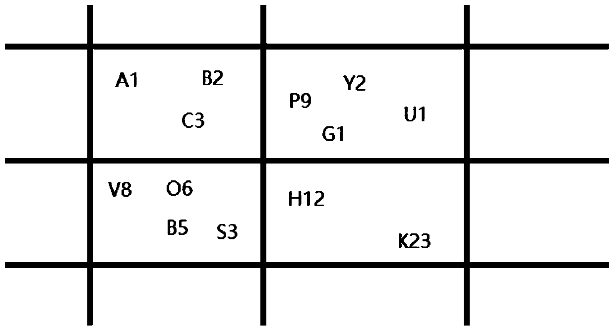
[0040] A. In the geographical coordinate system, successive blocks are divided successively, and the longitude and latitude coordinate positions of the aviation data are collected from the airborne navigation data. The aviation data includes waypoint data, navigation station data, airport data, and runway data. The aviation data are divided according to their latitude and longitude coordinates and marked into the blocks corresponding to the geographic coordinate system. The method for marking the aviation data in the block corresponding to the geographic coordinate system is: firstly establish a one-to-one mapping relationship table between the aviation data and the aviation data code (such as figure 1 As shown, the aeronautical data codes are marked on the geographic coordinate system, such as A1, B2, C3, Y2, P9, G1, U1, V8, O6, B5, S3, H12 or B23, and each aeronautical data code ...


PUM


Abstract

The invention discloses a clustering storage method for airborne navigation data, which comprises the following steps of: A, sequentially dividing continuous blocks in a geographic coordinate system,acquiring longitude and latitude coordinate positions of aviation data from the airborne navigation data, and respectively dividing and marking each piece of aviation data into blocks corresponding tothe geographic coordinate system according to longitude and latitude coordinates of each piece of aviation data; B, sequentially endowing all blocks in the geographic coordinate system with block identification information corresponding to each block according to a geographic position sequence; and C, performing clustering storage on the airborne navigation data: during airborne navigation data storage, storing the airborne navigation data and the block identification information in the same block into the same storage space, and establishing a block-based index database at the same time. According to the method, different types of aviation data are clustered and stored according to geographic positions, so that the data reading efficiency of airborne equipment can be improved, and the operation efficiency and real-time performance of the system are guaranteed.

Description

technical field [0001] The invention relates to a data storage and local fast loading method, in particular to a cluster storage method of airborne navigation data. Background technique [0002] Now advanced civil transport aviation aircraft will use flight management computer system to realize fully automatic navigation throughout the flight process, which greatly reduces the workload of pilots and improves the automation of aircraft operation. The flight management computer has a built-in on-board navigation database, and the flight management computer realizes fully automatic navigation by reading the on-board navigation data. [0003] In the application of flight management calculation or flight safety instructions, it is necessary to read the navigation data in the airborne navigation database. When reading the data, it is often necessary to filter various types of airborne data according to the latitude and longitude position, and the data within a certain range The n...

Claims


Application Information

Patent Timeline
Patent Type & Authority Applications(China)
IPC IPC(8): G06F16/27G06F16/22G06F21/78
CPCG06F16/27G06F16/2228G06F16/22G06F21/78
Inventor 王冠宇
Owner 航科院中宇(北京)新技术发展有限公司
Why Eureka
Try Eureka