Beidou/GPS tightly-combined virtual reference station positioning method

A technology of virtual reference station and positioning method, applied in the field of Beidou/GPS tight combination virtual reference station positioning, can solve the problems of weak observation model strength, affecting user positioning performance, difficult to deal with satellite signal occlusion, etc., to improve accuracy and increase redundancy. Redundancy, the effect of improving satellite positioning performance

Active Publication Date: 2020-06-19
HARBIN ENG UNIV
View PDF5 Cites 11 Cited by
  • Summary
  • Abstract
  • Description
  • Claims
  • Application Information

AI Technical Summary

Problems solved by technology

The traditional multi-system virtual reference station positioning technology adopts the loose combination mode, which needs to be applied in a relatively open space for receiving stars. It is required that no less than two visible satellites per system can be used for position calculation, and it is difficult to deal with satellite signal occlusion in complex environments. Problems greatly limit the release of the application potential of multi-base station positioning technology in navigation and positioni

Method used


Image

  • Beidou/GPS tightly-combined virtual reference station positioning method
  • Beidou/GPS tightly-combined virtual reference station positioning method
  • Beidou/GPS tightly-combined virtual reference station positioning method

Examples


Embodiment

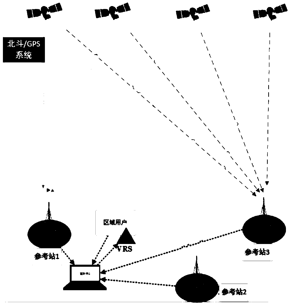
[0049] The present invention is based on the Beidou / GPS tight combined virtual reference station positioning method, and the specific steps include:

[0050] Step 1: Establish the Beidou / GPS system tightly combined double-difference observation equation between reference stations and determine the deviation expression between Beidou / GPS system

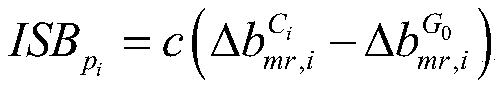
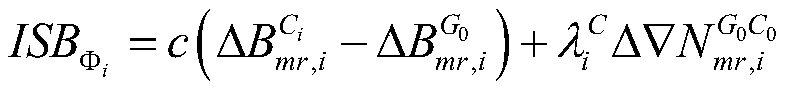
[0051] The pseudorange and carrier phase non-difference observation equation considering the deviation between systems can be expressed as:

[0052]

[0053] among them, They stand for pseudorange and carrier phase observations, superscript s stands for satellite, subscripts r and i stand for reference station receiver and satellite signal frequency respectively, cdt r Is the receiver clock error, cdt s Represents the satellite clock difference, cb r,i , They are receiver code hardware delay deviation and satellite code hardware delay deviation, cB r,i , They are the receiver phase hardware delay deviation and the satellite phase hardware d...


PUM


Abstract

The invention discloses a Beidou/GPS tightly-combined virtual reference station positioning method. The positioning method comprises the steps of establishing a pseudo-range and carrier phase tightly-combined double-difference observation equation, and determining a Beidou/GPS inter-system deviation expression; constructing an MW tight combination model, constructing a narrow lane integer ambiguity resolving model in a geometric correlation mode, and resolving the double-difference integer ambiguity of each frequency; establishing a double-difference ionospheric delay error and other error extraction models irrelevant to the ionospheric delay error; determining the position coordinates of the virtual observation station, solving each error value at the position of the virtual reference station, and obtaining the observed quantity of the virtual reference station; and constructing a short baseline Beidou/GPS tightly-combined double-difference observation equation of the virtual reference station and the user, and estimating the position of the user. According to the method, the positioning availability based on the virtual reference station method in the high-elevation environment is improved; the user positioning performance is improved; and a foundation is laid for application of a multi-reference station positioning technology in high-elevation environments such as forests, canyons and urban areas.

Description

Technical field [0001] The invention belongs to the technical field of satellite positioning and navigation, and specifically relates to a Beidou / GPS tight combined virtual reference station positioning method. Background technique [0002] Globally distributed ground reference stations are the infrastructure for obtaining spatial geographic features quickly and accurately, which expands the application range of satellite positioning. In order to further expand its application in complex environments, it is urgent to carry out research on providing high-precision positioning methods for forests, canyons, urban areas and other high-elevation environments. Based on the multi-reference station multi-mode multi-frequency positioning method, the advantages of high observable redundancy and wide range of action have become one of the effective methods for realizing satellite positioning in complex environments. As one of the core technologies of multi-reference station positioning, vi...

Claims


Application Information

Patent Timeline
IPC IPC(8): G01S19/44G01S19/42
CPCG01S19/44G01S19/421
Inventor 李慧高爽李南程建华赵琳
Owner HARBIN ENG UNIV
Why Eureka
Try Eureka