Soybean and corn planting area identification method in Jianghuai region based on Sentinel-2 image

A recognition method, soybean technology, applied in the field of crop image recognition, can solve problems such as complex planting structure, high proportion of satellite image cloud pollution, and increased difficulty in mapping

Active Publication Date: 2020-07-28
ANHUI UNIVERSITY
View PDF3 Cites 6 Cited by
  • Summary
  • Abstract
  • Description
  • Claims
  • Application Information

AI Technical Summary

Problems solved by technology

However, there are still some difficulties in the study of soybean and corn extraction under the background of remote sensing, especially in areas where there are many types of crops—the area between the Yangtze River and the Huaihe River (Anhui) where it is rainy and cloudy
First, the region has a high proportion of cloud pollution in satellite imagery due to climate change during soybean and corn growth
Second, smallholder planting results in complex planting structures
In addition, the difficulty of mapping the two crops is also increased due to the phenological and spectral similarities between soybean and maize

Method used


Image

  • Soybean and corn planting area identification method in Jianghuai region based on Sentinel-2 image
  • Soybean and corn planting area identification method in Jianghuai region based on Sentinel-2 image
  • Soybean and corn planting area identification method in Jianghuai region based on Sentinel-2 image

Examples


Embodiment 2

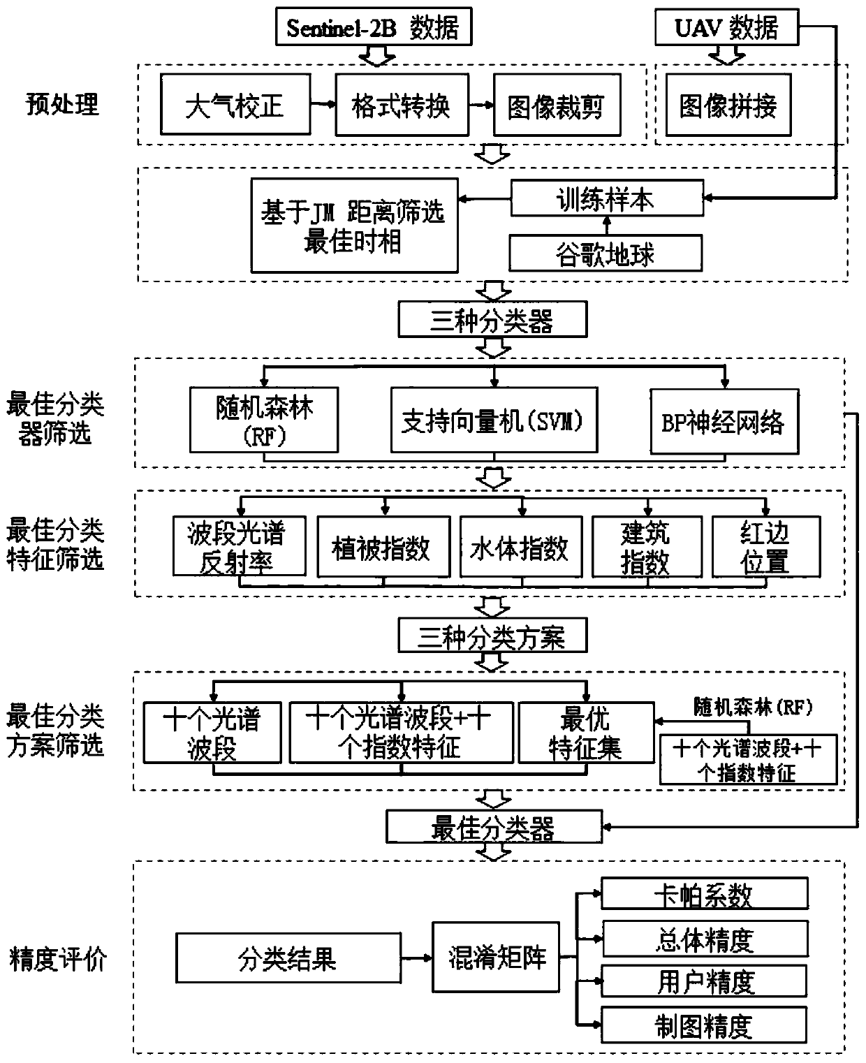
[0035] Embodiment 2, in the described step C, include the following steps: C11, extract a plurality of quadrat images with a set size from random positions in the satellite image, including soybeans, corn, sorghum, buildings, forests, roads in the quadrat area , water body, bare land, and other vegetation, a total of nine land cover types; C12, obtain the high-definition image of the corresponding position of the sample plot from the high-definition image taken by the drone equipped with a high-definition camera and Google Earth; C13, artificially mark the high-definition image of the corresponding position of the sample plot The land cover type in the image; C14. Correspond the marked land cover type to the satellite image of the original quadrat according to the coordinate position to form a training set; C15. Combine the training set data, 20 features, and the set decision The number of tree numbers and the number of feature variables used in each split node are substituted ...

Embodiment 3

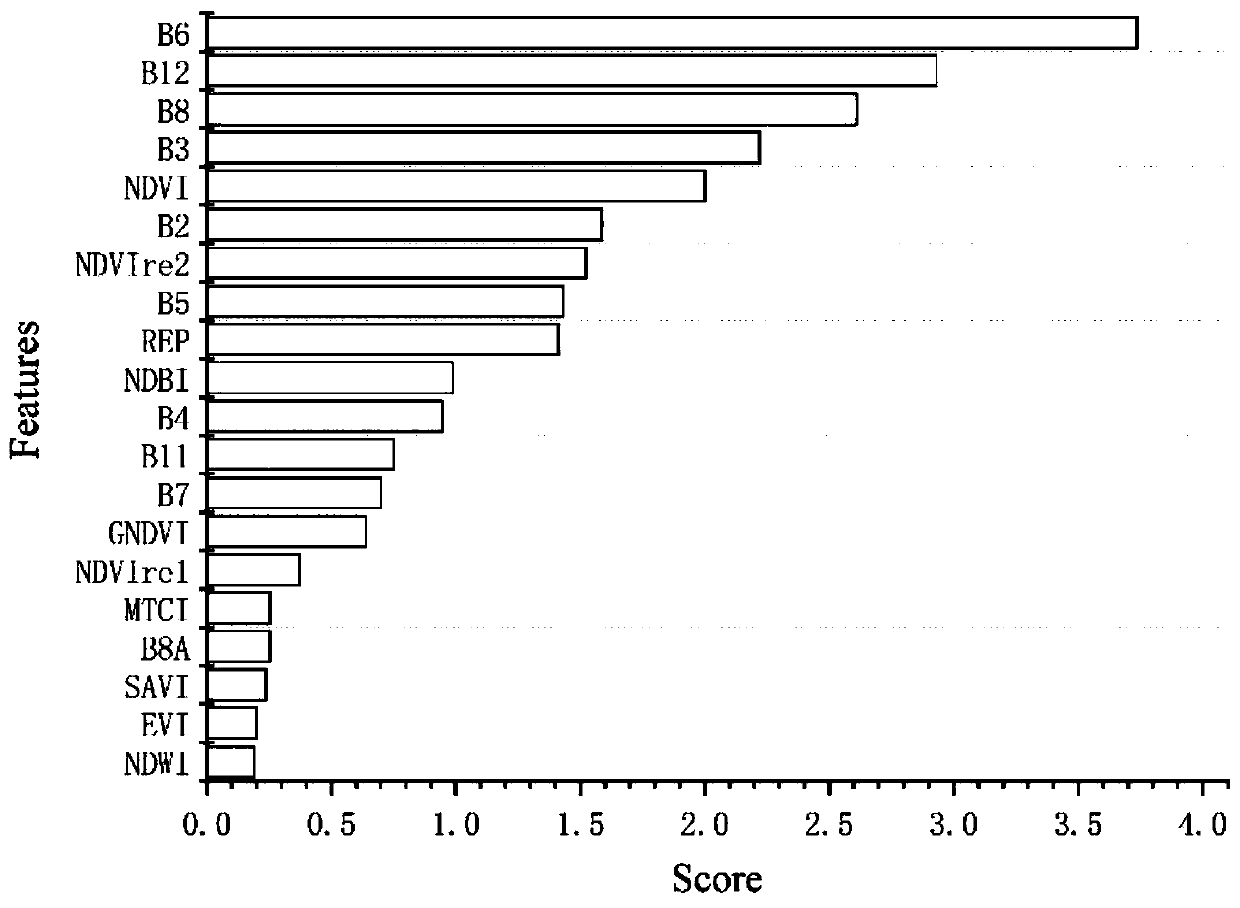
[0037] Embodiment three, in the described step C, include the following steps: C21, execute the steps C11-C14 in claim 6 to obtain the training set; C22, calculate the importance score of twenty features in the random forest algorithm; C23, According to the scores of the features from high to low, add twenty features to the random forest classifier in turn, build a classification model by sequential forward selection, and then verify the classification accuracy of different models to determine the number of features in the best feature set; C24, Substituting the training set data, the features in the best feature set, the set number of decision trees and the number of feature variables used in each split node into the random forest algorithm to train the second random forest algorithm model; C25. The image in step B is substituted into the second random forest algorithm model to realize the recognition of each pixel in the image. The more features, the longer the training time...


PUM


Abstract

The invention particularly relates to a soybean and corn planting area identification method in the Jianghuai region based on a Sentinel-2 image. The soybean and corn planting area identification method comprises the following steps: A, acquiring a to-be-detected region satellite image shot by a Sentinel-2 satellite, and preprocessing the to-be-detected region satellite image; b, calculating separability between land cover types by adopting a JM distance, and selecting an image of an optimal classification time phase; c, classifying pixel points in the target area image through a classification algorithm; and D, calculating the planting area of the soybeans/corns according to the number of the pixel points classified into the soybeans/corns. According to the method, the Sentinel-2 image data with relatively high spatial-temporal resolution is utilized, and the related classification algorithm is combined, so that the soybeans and the corns in the Jianghuai region can be well identified. Using these steps, before the soybeans and the corns are harvested, soybeans and corns are identified and drawn in a main producing area with a broken planting structure in a relatively rapid and low-cost mode, and a relatively reliable spatial distribution result of the soybeans and the corns is obtained, so that a technical support is provided for extracting the planting areas of the soybeansand the corns in areas with complex planting structures and changeable climates.

Description

technical field [0001] The invention relates to the technical field of crop image recognition, in particular to a method for recognizing soybean and corn planting areas in the Jianghuai region based on Sentinel-2 images. Background technique [0002] Soybean and maize, two crops that have received much attention in global food production, are widely grown around the world. As a high-yield food with high nutritional value, corn is known as a gold crop in the world; soybean is an important raw material for edible oil, protein food and feed protein, both of which occupy an important position in the world's food production security. China is one of the major producers of soybeans and corn. In 2018, China's corn sown area reached 42159kha, ranking first in the world, and soybean sown area reached 7974kha, ranking fifth in the world. Due to various needs such as animal feeding and edible oil pressing, the domestic supply of soybeans and corn is in short supply, and a large amoun...

Claims


Application Information

Patent Timeline
Patent Type & Authority Applications(China)
IPC IPC(8): G06T7/62G06N3/04G06N3/08G06K9/62
CPCG06T7/62G06N3/084G06T2207/10032G06T2207/20084G06T2207/30181G06N3/044G06N3/045G06F18/2411Y02A40/10
Inventor 张东彦杨玉莹佘宝黄林生梁栋杜世州赵晋陵彭代亮
Owner ANHUI UNIVERSITY
Why Eureka
Try Eureka