Urban and rural planning result data multidirectional conversion method

A technology for urban and rural planning and conversion methods, applied in geographic information databases, structured data retrieval, database management systems, etc., can solve problems such as long working hours, low efficiency, and spending a lot of time converting data, so as to improve work efficiency and reduce The effect of workload

Pending Publication Date: 2020-07-31
GUANGDONG URBAN & RURAL PLANNING & DESIGN INST
View PDF3 Cites 3 Cited by
  • Summary
  • Abstract
  • Description
  • Claims
  • Application Information

AI Technical Summary

Problems solved by technology

The vast majority of domestic statutory urban and rural planning results data use AutoCAD DWG for vector file drawing, storage and approval. DWG format data lacks unified spatial reference coordinates, and spatial data cannot be directly associated with attribute information. It is not convenient for planning results to be managed and quick view
[0003] With the promulgation of the "Guangdong Provincial Statutory Urban and Rural Planning Achievement Data Standard", professional and technical personnel need to spend a lot of time converting data
At present, the planning drawings in DWG format are converted into GDB format data, and technicians spend a lot of manpower on data format conversion, attribute table association, data topology inspection, field calculation, etc., which leads to long working hours and low efficiency.

Method used


Image

  • Urban and rural planning result data multidirectional conversion method

Examples


Embodiment 1

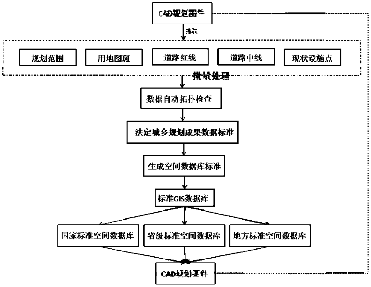
[0040] Such as figure 1 As shown, a multi-directional conversion method of urban and rural planning results data, the specific steps are:

[0041] Preprocess the CAD topographic map, divide the CAD topographic map into layers, planning range layer, map spot layer, road red line layer, road centerline layer and current implementation point layer;

[0042] According to the coating attribute mapping relationship, create a mapping relationship table, and create a reasonable corresponding relationship according to the relationship between layer data organization, layer data structure, symbols, coordinates and topology;

[0043] Check the topological problems in the source CAD data, and produce the path of the error data file; check the topological problems in the source CAD data mainly include: self-intersection problem, small surface problem, pattern overlapping problem, sharp angle problem and gap inspection;

[0044] Automatically associate the plot code in the CAD planning soi...


PUM


Abstract

The invention discloses an urban and rural planning result data multidirectional conversion method, and the method comprises the following specific steps: preprocessing a CAD topographic map, and dividing the CAD topographic map into map layers; creating a mapping relation table according to the coating attribute mapping relation; checking a topological problem in the source CAD data, and generating an error reporting data file path; automatically associating the plot code in the CAD planning soil file with the planned plot; determining urban and rural planning database standards according toan excel format method, generating a standard GIS format database, and transferring the CAD format planning drawing file into the standard format database; extracting CAD topographic map elements andconverting the CAD topographic map elements into a GIS database file; dividing layers according to layer fields, and exporting CAD color blocks as points, lines and surfaces; and converting the GIS format database into CAD format data according to the filling color and the line width style of the original CAD planning drawing file, and keeping the color and the line width style of the exported drawing file consistent with those of the original planning drawing. According to the method, the workload of data conversion is reduced to the maximum extent, and the working efficiency is improved by about 200%.

Description

technical field [0001] The invention relates to a data conversion method, in particular to a multi-directional conversion method for urban and rural planning result data. Background technique [0002] In order to implement the work content of the pilot province of Guangdong Province's urban and rural planning management system reform, promote the implementation of the reform and innovation of the overall urban planning, and meet the needs of planning informatization and the construction of a blueprint. The vast majority of domestic statutory urban and rural planning results data use AutoCAD DWG for vector file drawing, storage and approval. DWG format data lacks unified spatial reference coordinates, and spatial data cannot be directly associated with attribute information. It is not convenient for planning results to be managed and Quick look. [0003] With the promulgation of the "Guangdong Provincial Statutory Urban and Rural Planning Achievement Data Standard", professi...

Claims


Application Information

Patent Timeline
IPC IPC(8): G06F16/25G06F16/29
CPCG06F16/258G06F16/29
Inventor 王浩邱衍庆马星阮浩德詹龙圣潘俊钳杜勇
Owner GUANGDONG URBAN & RURAL PLANNING & DESIGN INST
Why Eureka
Try Eureka