Modular unmanned vehicle positioning method and system based on visual inertia laser data fusion

A technology of data fusion and positioning method, which is applied in radio wave measurement system, image data processing, photo interpretation and other directions, and can solve the problems that the robustness and accuracy cannot guarantee the application requirements, etc.

Active Publication Date: 2020-08-28
WUHAN UNIV OF TECH
View PDF7 Cites 54 Cited by
  • Summary
  • Abstract
  • Description
  • Claims
  • Application Information

AI Technical Summary

Problems solved by technology

Positioning schemes with one or two sensors alone, such as IMU trajectory deduction, visual inertial odometer, laser inertial odometer, etc., because of the limitations of the sensor itself, it is difficult to perform accurate positioning in complex environments (high-speed motion, weak light environments, etc.) Positioning, robustness and accuracy cannot guarantee application requirements, and how to rationally utilize the advantages of each sensor in a multi-sensor fusion solution is also a major challenge

Method used


Image

  • Modular unmanned vehicle positioning method and system based on visual inertia laser data fusion
  • Modular unmanned vehicle positioning method and system based on visual inertia laser data fusion
  • Modular unmanned vehicle positioning method and system based on visual inertia laser data fusion

Examples


Embodiment Construction

[0087] In order to make the object, technical solution and advantages of the present invention more clear, the present invention will be further described in detail below in conjunction with the examples. It should be understood that the specific embodiments described here are only used to explain the present invention, not to limit the present invention.

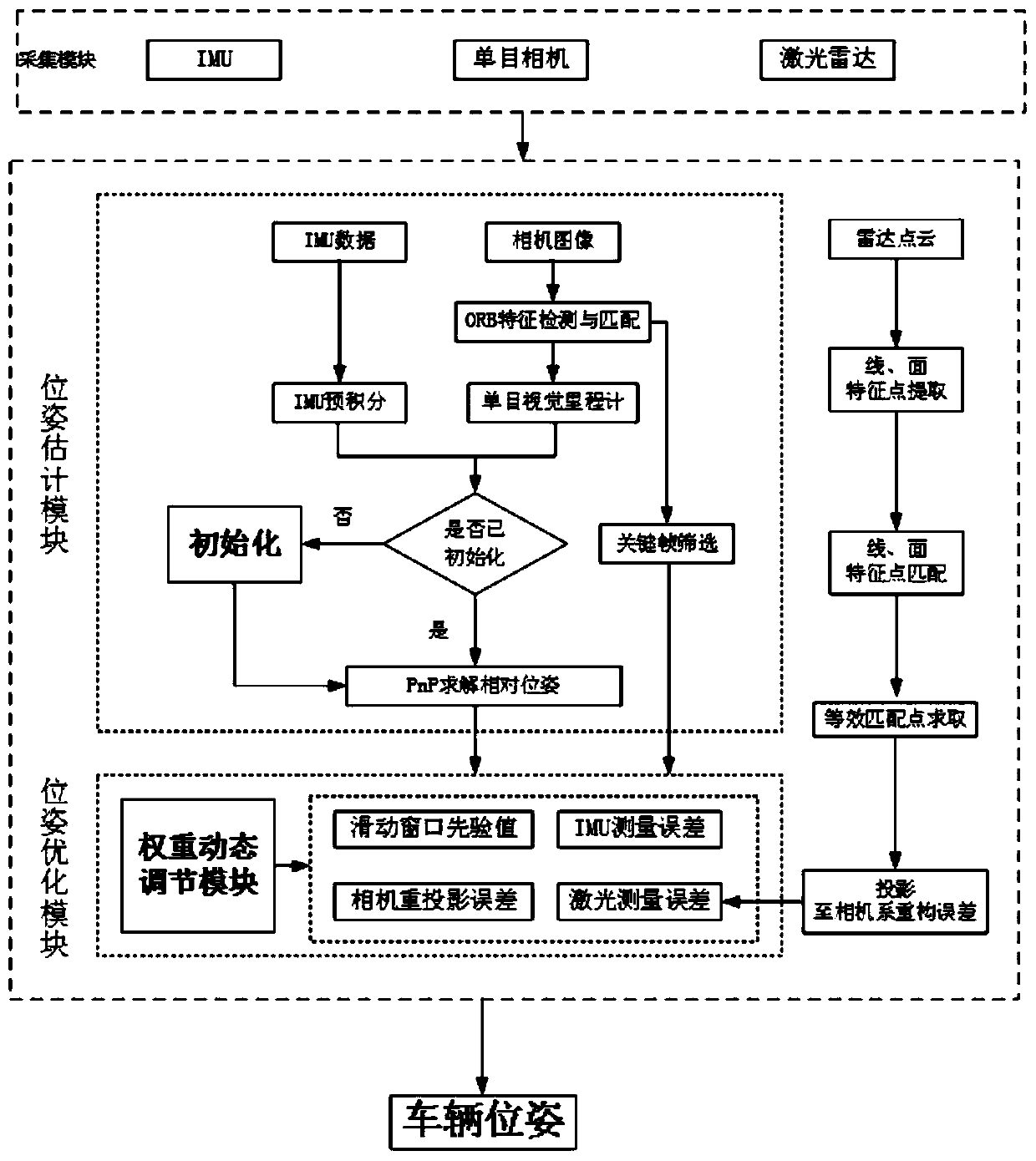
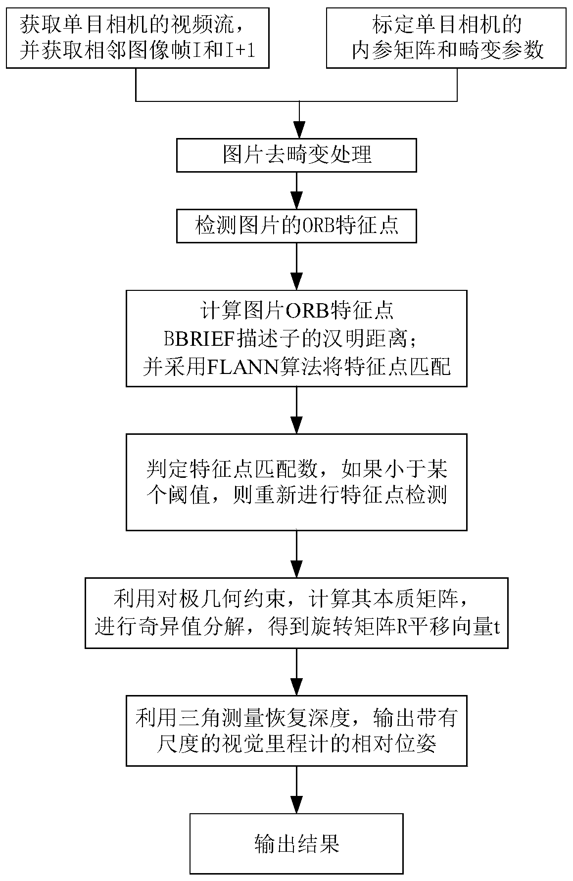
[0088] like figure 1 As shown, a modular unmanned vehicle positioning system based on visual inertial laser data fusion. The sensors involved in the acquisition module include IMU, laser radar, and monocular camera. The real-time detection data of the three sensors are transmitted to the processing module in the system for processing. The system carries out a separate design of multiple modules. The pose estimation module solves the scale problem of the monocular visual odometer through the joint initialization of the IMU and the monocular camera; the pose optimization module accepts the pose information from the pose estim...


PUM


Abstract

The invention discloses a modular unmanned vehicle positioning method and system based on visual inertia laser data fusion. The method comprises the following steps that (1), an acquisition module acquires current information of an unmanned vehicle through a monocular camera, a laser radar and an IMU; (2), according to the current information of the driverless vehicle collected in the step (1), apose estimation module performs pose estimation of the vehicle through a monocular odometer and an IMU pre-integration model to obtain pose information of the unmanned vehicle; and (3), a pose optimization module establishes a multi-sensor fusion optimization model according to the pose estimation information in the step (2), a weight coefficient dynamic adjustment module adjusts the optimizationproportion of each sensor to enhance the environmental adaptability, the optimal pose of the vehicle is obtained after optimization, and the optical pose is converted into a world coordinate system to obtain the real-time pose of the vehicle. The method can meet the requirements for accuracy and robustness of positioning of the unmanned vehicle in a complex environment, and is suitable for positioning of the unmanned vehicle in the complex environment.

Description

technical field [0001] The invention relates to intelligent vehicle positioning technology, in particular to a modular unmanned vehicle positioning method and system based on visual inertial laser data fusion. Background technique [0002] With the rapid development of social economy and science and technology, people's demand for travel is becoming more and more vigorous, and cars have gradually become an indispensable means of transportation in people's lives. After years of development, in order to cope with the increasingly complex and changing needs in the future, the traditional automobile industry has also seen a wave of research on unmanned driving technology. For example, Baidu, Huawei, Yushi, etc. in China, and technology companies such as Google, Tesla, and chip manufacturers such as NVIDIA in foreign countries have joined the research and development of driverless technology. At present, major domestic universities have also begun to attach importance to the dev...

Claims


Application Information

Patent Timeline
Patent Type & Authority Applications(China)
IPC IPC(8): G01C21/16G01C11/04G01S17/86G06K9/46G06K9/62G06T7/73
CPCG01C21/165G01C11/04G01S17/86G06T7/75G06T2207/10016G06T2207/10028G06V10/443G06F18/25Y02T10/40
Inventor 李其仲童祺堃黄妙华
Owner WUHAN UNIV OF TECH
Why Eureka
Try Eureka