Multi-stage health state acquisition method for low-orbit remote sensing satellite navigation positioning system

A technology of navigation and positioning and health status, which is applied in the field of multi-level health management of low-orbit remote sensing satellite onboard navigation and positioning system, and can solve problems that do not involve low-orbit remote sensing satellite multi-level health status information monitoring and health management, low-orbit remote sensing satellite The limited controllable arc on the ground affects the optimal realization of remote sensing satellite functions, etc., so as to improve robustness and service continuity, prevent the spread of faults, and improve the efficiency of information control

Active Publication Date: 2020-09-04
BEIJING INST OF SPACECRAFT SYST ENG
View PDF12 Cites 6 Cited by
  • Summary
  • Abstract
  • Description
  • Claims
  • Application Information

AI Technical Summary

Problems solved by technology

[0004] However, limited by the orbital height and the ground measurement and control station, the controllable arc section of the ground for low-orbit remote sensing satellites is very limited.
On the one hand, the ground may not be able to monitor the non-persistent faults that occur outside the arc; on the other hand, relying entirely on the ground to conduct uplink command control after a series of analysis and diagnosis to identify the fault, the timeliness is poor, causing a delay in fault repair and long-term Optimum realization of time-affected remote sensing satellite functions
[0005] The existing technology only provides a single-level monitoring method for certain types of faults in the spaceborne navigation and positioning system, and does not involve the multi-level health status information monitoring and health management of low-orbit remote sensing satellites for the entire operation process of the navigation and positioning system. At present, there are also No patent yet covers this multi-level health management method

Method used


Image

  • Multi-stage health state acquisition method for low-orbit remote sensing satellite navigation positioning system
  • Multi-stage health state acquisition method for low-orbit remote sensing satellite navigation positioning system
  • Multi-stage health state acquisition method for low-orbit remote sensing satellite navigation positioning system

Examples


Embodiment Construction

[0046] In the following, the technical solutions of the present invention will be further described in detail in conjunction with the accompanying drawings. It should be noted that the specific embodiments described here are only used to explain the present invention, and the present invention is not limited to the embodiments.

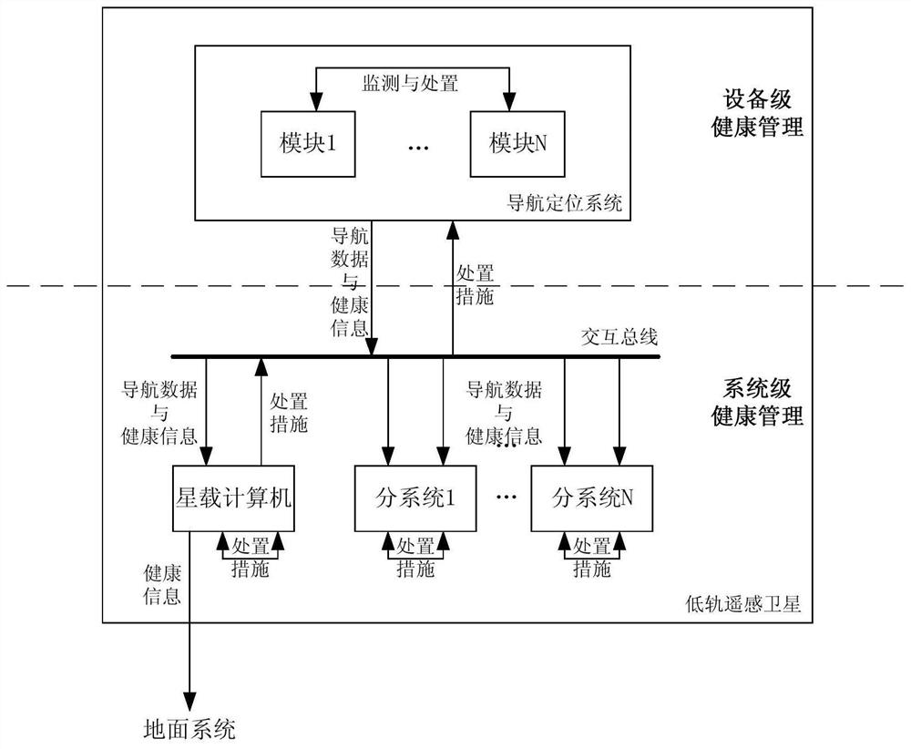
[0047] The low-orbit remote sensing satellite navigation and positioning system obtains navigation observation data by receiving, capturing and tracking GPS navigation signals, completes the calculation of time, position and speed information of low-orbit remote sensing satellites, and provides camera integration time, radar ranging information. A method for obtaining multi-level health status of a low-orbit remote sensing satellite navigation and positioning system provided by the present invention, such as figure 1 , including the following levels:

[0048] Level 1: Device-level health management;

[0049] Level 2: System-level health management. ...


PUM


Abstract

The invention provides a multi-stage health state acquisition method for a low-orbit remote sensing satellite navigation positioning system. The multi-level health management comprises: equipment-level health management and system-level health management; wherein the equipment-level health management comprises equipment operation health management and equipment function health management; the system-level health management comprises: a navigation positioning system operation health management and navigation positioning system function health management. The implementation body of the system-level health management comprises a satellite-borne computer, an orbit control subsystem and a payload subsystem, wherein information interaction exists between the satellite-borne computer and a navigation and positioning system in a low-orbit remote sensing satellite. The invention provides a multistage health management method for a low-orbit remote sensing satellite navigation positioning system. Compared with single-level health management, the management means are more diverse, the health state is more comprehensively reflected, the limitation of fault handling in single-level health management is solved, and on-orbit autonomous safe operation of the low-orbit remote sensing satellite can be more powerfully guaranteed.

Description

technical field [0001] The invention relates to a health management method of an on-board navigation and positioning system, in particular to a multi-level health management method of a low-orbit remote sensing satellite on-board navigation and positioning system. Background technique [0002] Low-orbit remote sensing satellites are widely used in surveying and mapping, resource investigation, environmental monitoring and other fields. High-precision satellite time, in-orbit position, speed and related derivative information help to improve the quality of image data acquired by payloads. Therefore, my country's current The low-orbit remote sensing satellites developed are generally equipped with on-board navigation and positioning systems to provide the above-mentioned satellite time and orbit-related information. The on-orbit navigation and positioning system is in a high-speed calculation state for a long time, and the space environment in which the low-orbit remote sensing...

Claims


Application Information

Patent Timeline
Patent Type & Authority Applications(China)
IPC IPC(8): G01C25/00G01S19/23G01S7/40
CPCG01C25/00G01S19/23G01S7/4004
Inventor 姚鑫雨张莎莎任放赵晨光曹海翊张新伟莫凡徐驰国爱燕赵里恒
Owner BEIJING INST OF SPACECRAFT SYST ENG
Why Eureka
Try Eureka