Remote sensing image data generation method, system and equipment

A remote sensing image and data generation technology, applied in the field of geographic surveying and mapping, can solve the problems of long quantity transmission and processing cycle, many factors affecting data instructions, and high cost of geographic information collection, and achieves good timeliness, high resolution, and low cost. Effect

Active Publication Date: 2020-09-22
SHENZHEN UNIV
View PDF6 Cites 5 Cited by
  • Summary
  • Abstract
  • Description
  • Claims
  • Application Information

AI Technical Summary

Problems solved by technology

[0005] In view of the deficiencies in the above-mentioned prior art, the purpose of the present invention is to provide users with a remote sensing data generation method, system and equipment to overcome the high cost of geographical information collection, long data transmission and processing cycle in the remote control technology in the prior art. , poor immediacy and many factors affecting data instructions

Method used


Image

  • Remote sensing image data generation method, system and equipment
  • Remote sensing image data generation method, system and equipment
  • Remote sensing image data generation method, system and equipment

Examples


Embodiment Construction

[0044] In order to make the object, technical solution and advantages of the present invention more clear and definite, the present invention will be further described in detail below with reference to the accompanying drawings and examples. It should be understood that the specific embodiments described here are only used to explain the present invention, not to limit the present invention.

[0045] Those skilled in the art can understand that, unless otherwise defined, all terms (including technical terms and scientific terms) used herein have the same meaning as commonly understood by those of ordinary skill in the art to which this invention belongs. It should also be understood that terms, such as those defined in commonly used dictionaries, should be understood to have meanings consistent with their meaning in the context of the prior art, and unless specifically defined as herein, are not intended to be idealized or overly Formal meaning to explain.

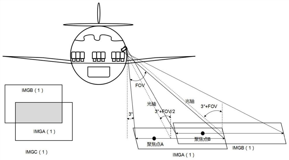
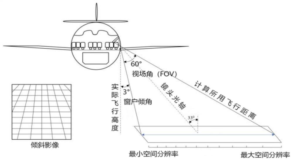
[0046] Since remo...


PUM


Abstract

The invention provides a remote sensing image data generation method, system and equipment. The method comprises the steps of shooting multiple groups of multi-focus inclined images in a target area through shooting equipment on an airplane; performing image registration on the acquired multiple groups of multi-focus inclined images and fusing overlapping regions to obtain multiple groups of spliced images; performing three-dimensional reconstruction on all the spliced images to generate dense point cloud; generating a digital surface model for the dense point cloud; correcting the fused multiple groups of spliced images based on the digital surface model and the position information of each set of shooting equipment to obtain orthoimages; and splicing the orthoimages into remote sensing image data of the target area. The method disclosed by the embodiment of the invention is low in cost, good in timeliness and high in data resolution, realizes low-cost collection and image data processing, and obtains high-resolution remote sensing image data.

Description

technical field [0001] The invention relates to the technical field of geographic surveying and mapping, in particular to a method, system and equipment for generating remote sensing image data. Background technique [0002] Remote sensing technology began in the 1960s. It can collect the surface radiation and electromagnetic wave information of the target object at a long distance through various sensing instruments, and process it into an image, so as to meet the needs of detection and identification of the target scene. It is an important aspect of geographic information. method of obtaining. [0003] Geographic information collection tasks usually require sensors to be fixed on platforms such as balloons, aircraft models, airplanes, artificial satellites, spacecraft, and space laboratories, and then the data is transmitted and processed into usable data. These traditional remote sensing technologies have shortcomings such as high cost, long period, lack of immediacy, an...

Claims


Application Information

Patent Timeline
Patent Type & Authority Applications(China)
IPC IPC(8): G01C11/26G01C5/00G06T3/40G06T7/30G06T5/00G06T17/00
CPCG01C11/26G01C5/005G06T3/4038G06T7/30G06T5/002G06T17/00G06T2207/10028G06T2207/20221
Inventor 汪驰升唐倩迪胡忠文张德津涂伟周宝定李清泉
Owner SHENZHEN UNIV
Why Eureka
Try Eureka