Centralized processing and distributed operation framework construction method for spatial data services

A technology of spatial data and construction methods, applied in data processing applications, analysis materials, surveying and navigation, etc., can solve the problem of inability to interactive job planning and collaborative operation, lack of centralized processing and distributed operation framework, and unable to meet urgent needs. requirements and other issues, to achieve the effect of reducing time redundancy, realizing centralized processing and distributed collaborative operations, and improving effective connection

Pending Publication Date: 2020-10-09
BEIJING GEOWAY SOFTWARE
View PDF0 Cites 4 Cited by
  • Summary
  • Abstract
  • Description
  • Claims
  • Application Information

AI Technical Summary

Problems solved by technology

According to incomplete statistics, the daily remote sensing image data obtained nationwide has reached the PB level, and the spatial remote sensing data to be processed has obvious characteristics of large data volume. Currently, GPU hardware acceleration and cluster processing are mainly used for large data volume remote sensing data. , cloud computing, high-performance computing and other processing technologies for several business types or processing scenarios, can only solve the batch or distributed processing of local large-scale spatial data business scenarios. Due to the inability of intelligent integration and balanced scheduling of computing resources, the inability to plan and coordinate interactive operations, etc., there is currently no centralized processing and distributed operation framework for large-volume spatial data services, which cannot meet the needs of the increasingly The urgent need for intelligent processing of space remote sensing data with increasing large data volume
[0003] With the continuous improvement of hyperspectral aerospace remote sensing image technology, rapid re

Method used


Image

  • Centralized processing and distributed operation framework construction method for spatial data services
  • Centralized processing and distributed operation framework construction method for spatial data services
  • Centralized processing and distributed operation framework construction method for spatial data services

Examples


Embodiment Construction

[0040] The following will clearly and completely describe the technical solutions in the embodiments of the present invention with reference to the accompanying drawings in the embodiments of the present invention. Obviously, the described embodiments are only some, not all, embodiments of the present invention. All other embodiments obtained by persons of ordinary skill in the art based on the embodiments of the present invention belong to the protection scope of the present invention.

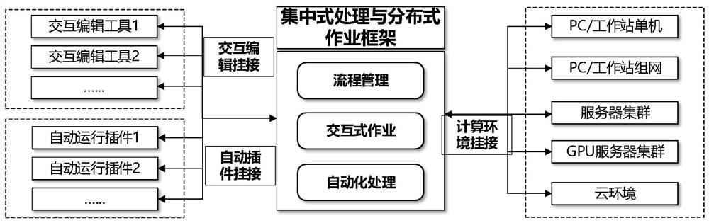
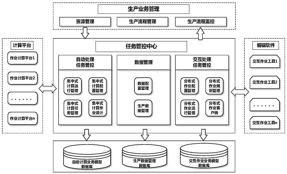
[0041] As shown in Figures 1-6, according to the centralized processing and distributed job framework construction method for spatial data services described in the embodiment of the present invention, the method includes:

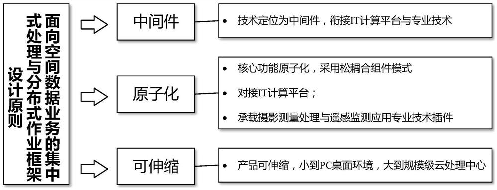
[0042]Standardize the organization of spatial data and processing services. Through in-depth analysis of data processing characteristics, centralized parallel computing is used for automatic processing services, and interactive services are integrated into the framework in...


PUM


Abstract

The invention discloses a centralized processing and distributed operation framework construction method for a spatial data service. The method comprises the following steps: deep analysis of data processing characteristics is performed, and standardized organization is carried out on spatial data and processing services; automatic processing services are integrated into a framework in a centralized parallel computing mode, and interactive editing services are integrated into the framework in a distributed operation mode, so unified regularization processing of spatial data is realized; and meanwhile, a spatial data processing framework is designed based on three principles of middleware, atomization and telescoping, so that the framework can be suitable for various operation scenes in thetechnical field of photogrammetry and remote sensing monitoring application. The invention has the advantages that intelligent production of large-data-volume spatial data is achieved, time redundancy caused by offline function circulation is reduced, connection between an automatic processing service and an interactive operation task is effectively improved, and centralized processing and distributed cooperative operation under various service scenes for spatial data processing are achieved.

Description

technical field [0001] The invention relates to the technical field of photogrammetry and remote sensing monitoring applications, in particular to a centralized processing and distributed operation framework construction method for spatial data services. Background technique [0002] With the rapid development of my country's aerospace technology, surveying and mapping technology, and Internet technology, air and ground data acquisition techniques have been continuously enhanced. Remote sensing data types, spatial resolution, time resolution, and spectrum Both resolution and radiometric resolution have made leaps and bounds, and the amount of space remote sensing data that can be obtained has also increased dramatically. According to incomplete statistics, the daily remote sensing image data obtained nationwide has reached the PB level, and the spatial remote sensing data to be processed has obvious characteristics of large data volume. Currently, GPU hardware acceleration an...

Claims


Application Information

Patent Timeline
IPC IPC(8): G06Q10/06G01C11/00G01N21/17
CPCG06Q10/0633G01C11/00G01N21/17G01N2021/1793Y02P90/30
Inventor 黎珂陈伯斌王立志
Owner BEIJING GEOWAY SOFTWARE
Why Eureka
Try Eureka