A Panchromatic Sharpening Method of Remote Sensing Image Based on Generative Adversarial Network

A remote sensing image and network technology, applied in the field of fusion of panchromatic images and multispectral images, to achieve the effect of maintaining stability and coherence, reducing information loss, and fast speed

Active Publication Date: 2021-07-09
TIANJIN UNIV
View PDF5 Cites 0 Cited by
  • Summary
  • Abstract
  • Description
  • Claims
  • Application Information

AI Technical Summary

Problems solved by technology

However, due to the limitations of signal transmission bands and imaging sensor storage, most remote sensing satellites only provide multispectral (MSI) images with low spatial / high spectral resolution and panchromatic (PAN) images with high spatial / low spectral resolution. The two images are highly complementary

Method used


Image

  • A Panchromatic Sharpening Method of Remote Sensing Image Based on Generative Adversarial Network
  • A Panchromatic Sharpening Method of Remote Sensing Image Based on Generative Adversarial Network
  • A Panchromatic Sharpening Method of Remote Sensing Image Based on Generative Adversarial Network

Examples


Embodiment Construction

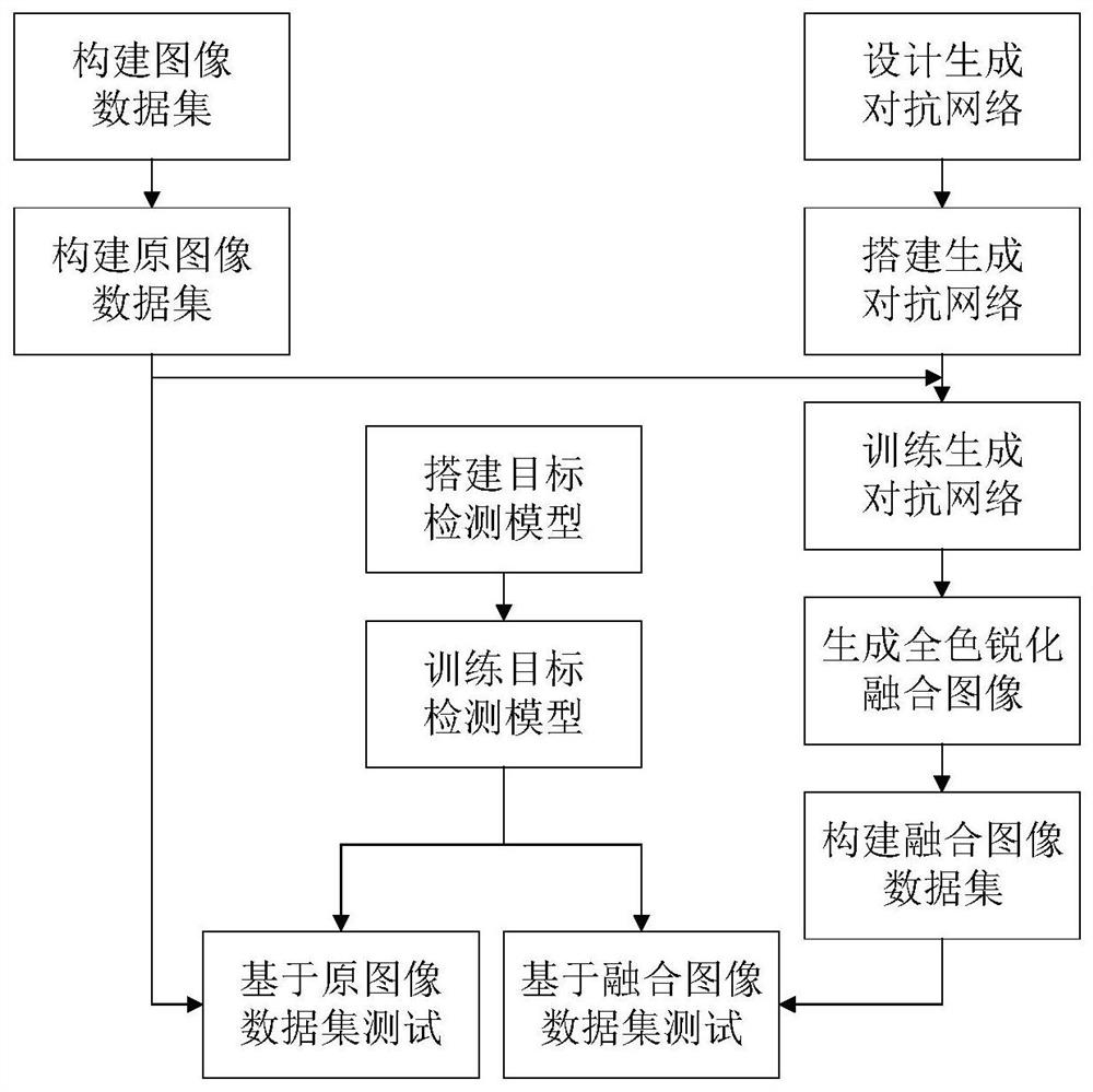
[0021] In order to make the technical solution of the present invention clearer, the specific implementation manners of the present invention will be further described below. Such as figure 1 Shown, the present invention is concretely realized by the following steps:

[0022] 1. Construction of large-scale remote sensing image datasets

[0023] The present invention mainly selects remote sensing image collections such as SpaceNet on AWS disclosed on the Internet to construct data sets. Taking the RIO data set in SpaceNet as an example, it contains 50cm image data and coordinates. The source of the image is the WorldView-2 satellite of DigitalGlobe, which can be used for image Segmentation and detection and many other applications.

[0024] SpaceNet is a large-scale remote sensing image data set hosted on Amazon's AWS cloud service platform. It was jointly completed by DigitalGlobe, CosmiQ Works and NVIDIA. It contains an online repository of satellite images and marked train...


PUM


Abstract

The invention relates to a method for panchromatic sharpening of remote sensing images based on generative confrontation networks, including: 1) constructing a data set: performing target classification and labeling on remote sensing image data, and constructing an original image data set including panchromatic images and spectral images; 2) Design the generation network and discriminant network model: the generation network model G of GAN learns from the random noise vector and the image in the data set, and trains the mapping to the generated sample image y. After G is trained, the generated sample image cannot be The discriminative network model is discriminated as false, and the discriminative network model D uses a convolutional neural network. After training, it can discriminate the authenticity of the generated data, and can complete the classification problem of discriminating the authenticity of the generated sample image as best as possible; 3 ) to train the Generative Adversarial Network model.

Description

technical field [0001] The invention relates to the fields of remote sensing image processing, image fusion, deep learning, etc., in particular to a fusion method of panchromatic images and multispectral images in the field of remote sensing, and belongs to the technical field of remote sensing image fusion. Background technique [0002] Remote sensing images with high spatial resolution and spectral resolution have obvious practical significance for object detection, geographic mapping and environmental monitoring. However, due to the limitations of signal transmission bands and imaging sensor storage, most remote sensing satellites only provide multispectral (MSI) images with low spatial / high spectral resolution and panchromatic (PAN) images with high spatial / low spectral resolution. The two images are highly complementary. Taking advantage of the differences and complementarities of the two images, they are fused into a fused image with clear spatial details and rich spe...

Claims


Application Information

Patent Timeline
Patent Type & Authority Patents(China)
IPC IPC(8): G06T5/00G06T9/00
CPCG06T5/003G06T9/002G06T2207/10036G06T2207/10041
Inventor 侯春萍夏晗杨阳管岱莫晓蕾
Owner TIANJIN UNIV
Why Eureka
Try Eureka