Inversion method for soil salinity of Yellow River delta based on Landsat8

A soil and salinity technology, applied in the field of inversion, which can solve problems such as inability to accurately write expressions, difficult for researchers to refer to, and lack of remote sensing inversion models.

Active Publication Date: 2020-10-16
QINGDAO AGRI UNIV
View PDF4 Cites 5 Cited by
  • Summary
  • Abstract
  • Description
  • Claims
  • Application Information

AI Technical Summary

Problems solved by technology

Through research and comparison, it is found that the model constructed by the BP neural network method has the highest accuracy, the model R2 is as high as 0.966, and the model can obtain the soil salinity in the area in a timely and accurate manner, but because it is a black box model, it is impossible to accurately write the expression, and it is difficult for researchers Refer to this type of model
[0005] Based on the above analysis, there is currently a lack of easy-to-operate remote sensing inversion models covering all planted crops in the Yellow River Delta region.

Method used


Image

  • Inversion method for soil salinity of Yellow River delta based on Landsat8
  • Inversion method for soil salinity of Yellow River delta based on Landsat8
  • Inversion method for soil salinity of Yellow River delta based on Landsat8

Examples


Embodiment Construction

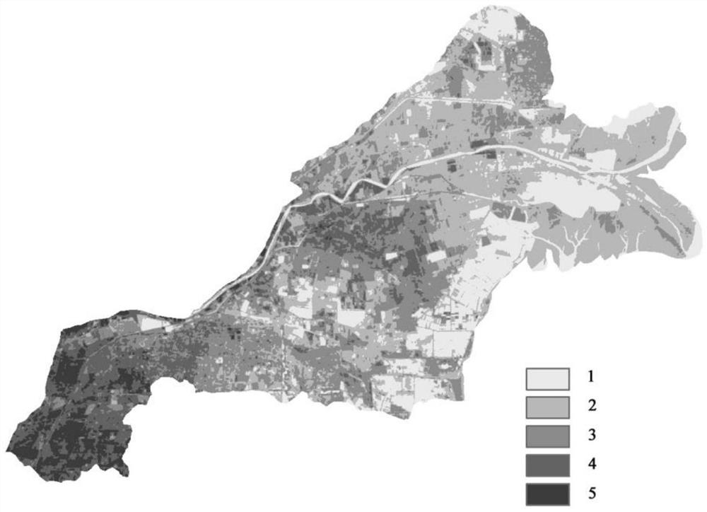
[0032] The present invention uses Landsat8 OLI images and the soil salinity content measured in the laboratory as the data source, uses mathematical statistical analysis methods to establish a soil salinity estimation model in the Yellow River Delta region, explores the sensitive band of soil salinity and the best inversion model, and provides accurate information for the future. It provides certain technical support for the acquisition of soil salinity in this area, and provides a basis for soil salinization control and prevention in the Yellow River Delta area, new national policies and sustainable development.

[0033] The present invention provides the inversion method based on Landsat8 to the soil salinity of the Yellow River Delta. The specific method is as follows:

[0034] S1: The collection and acquisition of soil salinity data, in order to make the sampling points accurately reflect the actual situation of the study area, it is necessary to comprehensively consider th...


PUM


Abstract

The invention discloses an inversion method for soil salinity of a Yellow River delta based on Landsat8. The inversion method comprises the following specific steps: S1, collecting and acquiring soilsalinity data; S2, acquiring and processing remote sensing image data; S3, extracting and calculating reflectivity data of each wave band of the Landsat8 OLI image; S4, after carrying out corresponding 1g (R) and 1 / R change on each waveband, respectively carrying out correlation analysis on the reflectivity of remote sensing and the converted reflectivity of remote sensing and the salt content ofsoil, and preliminarily screening sensitive wavebands; S5, performing multiple linear regression analysis on the 1 / R, 1g (R) of the reflectivity of each waveband and the salt content of the soil obtained in the step S1, and establishing a regression model; and S6, applying the established optimal prediction model to the Landsat8 remote sensing image of the research area to obtain a Landsat8 soil salinity content remote sensing inversion graph. According to the method, the inversion model is used for inverting the soil salt content and carrying out descriptive statistical analysis, the soil salt content is compared with the actually-measured soil salt content, it is found that the salt content is basically consistent, and it shows that the inversion model is high in precision and good in stability.

Description

【Technical field】 [0001] The invention provides and relates to a kind of inversion method, be specifically related to a kind of inversion method to the soil salinity of Yellow River Delta based on Landsat8. 【Background technique】 [0002] Soil salinization refers to the phenomenon of salt accumulation in arid and semi-arid areas, due to the rise of groundwater table, the evaporation of soil water surface is greater than the recharge of groundwater. The phenomenon of soil salinization in my country is serious, and the area of ​​saline soil is about 1.0x10⁸ha, among which the residual saline soil is the highest, up to 45%, followed by modern saline soil, and shallow saline soil is the least. Among them, the coastal saline soil is mainly located in the eastern part of my country and the coastal areas of the South China Sea [18], with a coastline of more than 18,000 kilometers in length, spanning a latitude of 24 degrees from south to north. [0003] The Yellow River Delta regi...

Claims


Application Information

Patent Timeline
Patent Type & Authority Applications(China)
IPC IPC(8): G06F30/20G06F17/18
CPCG06F30/20G06F17/18A01B79/005G06V20/194G06V20/13
Inventor 张晓光
Owner QINGDAO AGRI UNIV
Why Eureka
Try Eureka