
Method for improving spatial resolution of precipitation data

A technology with high spatial resolution and data space, applied in the field of satellite remote sensing data processing, can solve problems such as inability to apply precipitation downscaling, hourly average or daily average precipitation downscaling, etc.

Pending Publication Date: 2020-10-20
丁思哲
View PDF1 Cites 2 Cited by
  • Summary
  • Abstract
  • Description
  • Claims
  • Application Information

AI Technical Summary

Problems solved by technology

The above scheme is only suitable for downscaling of annual average precipitation data, and cannot be used for downscaling of hourly or daily average precipitation
In addition, variables such as vegetation index, surface temperature, elevation, slope, and aspect are all relevant geographical parameters on land, so the above-mentioned precipitation downscaling scheme cannot be applied to the downscaling of precipitation on the ocean

Method used


Image

  • Method for improving spatial resolution of precipitation data
  • Method for improving spatial resolution of precipitation data
  • Method for improving spatial resolution of precipitation data

Examples


Embodiment 1

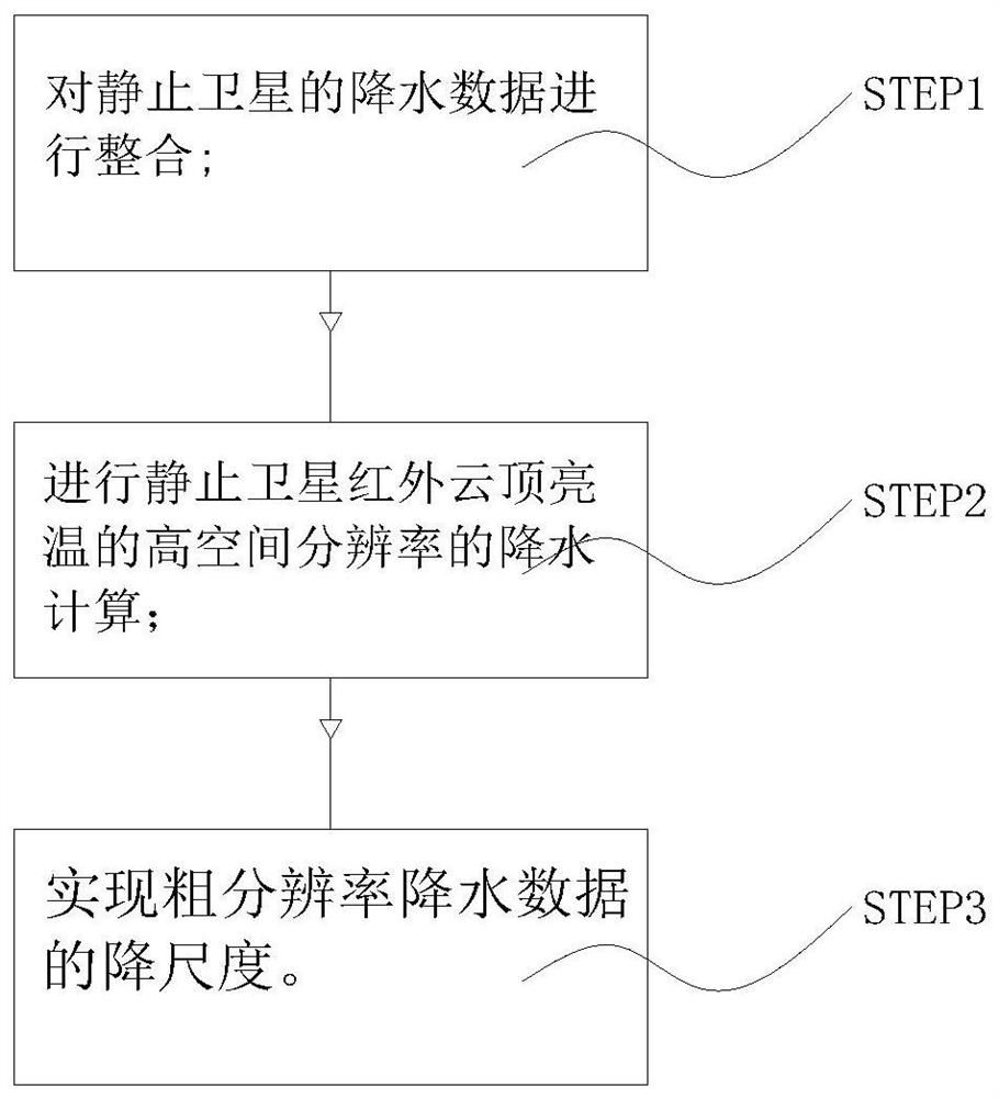
[0049] Such as Figure 1 to Figure 3 As shown in , the geostationary satellite integrated data is introduced, and the integrated data is the geostationary satellite infrared band integrated data with high temporal and spatial resolution.

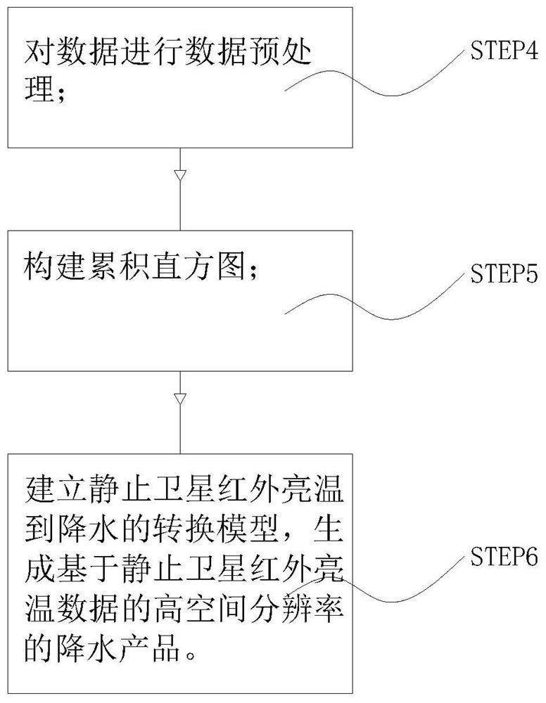
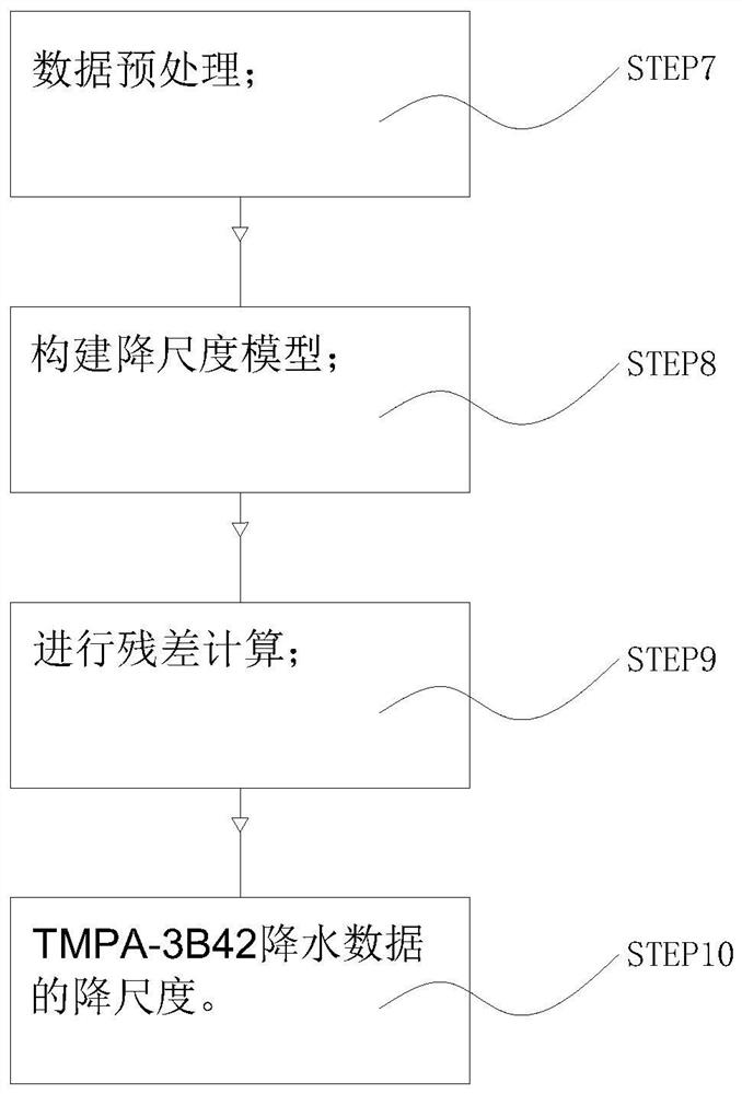
[0050] Execute STEP1 to calculate precipitation with high spatial resolution based on geostationary satellite infrared cloud top brightness temperature. In STEP1, execute STEP4, data preprocessing. The data used include TMPA-3B42 precipitation products with a spatial resolution of 0.25°×0.25° and a temporal resolution of 3 hours and / or NCEP-IR with a spatial resolution of 4km×4km and a temporal resolution of 30 minutes. For the NCEP-IR that matches TPMA-3B42 in time, the selected NCEP-IR is resampled into data with two equal longitude and latitude spatial resolutions: 0.25°×0.25° and 0.05°×0.05°.

[0051] Execute STEP5 to build a cumulative histogram. Extract the date N at time t, and then select the date N-16 to N+16, the TMPA-3B42 preci...

Embodiment 2

[0058] At present, the spatial resolution of long-term global precipitation integration products is mostly 0.25°. The precipitation downscaling method proposed in the patent of the present invention can increase the spatial resolution of precipitation data on land and oceans worldwide from 0.25° to 0.05°. It enables users to obtain more refined precipitation spatial distribution data on a global scale, and provides richer information for global flood disaster monitoring, drought monitoring, and water resource distribution investigation. Compared with the existing downscaling method, the precipitation downscaling method provided by the patent of the present invention can improve the spatial resolution of the data while ensuring that the downscaled precipitation data is comparable to the original data in terms of accuracy and time resolution. reduce while retaining the spatial distribution trend of the original precipitation data.

[0059] In this example, if image 3 As shown...


PUM


Abstract

The invention discloses a method for improving the spatial resolution of precipitation data. The method comprises the following steps: integrating precipitation data of a stationary satellite, performing precipitation calculation on the high spatial resolution of infrared cloud top brightness temperature of the stationary satellite, and downscaling coarse-resolution precipitation data. The spatialresolution of precipitation data on the inland and ocean in the global range can be improved from 0.25 DEG to 0.05 DEG, so a user can obtain finer precipitation spatial distribution data in the global range, and richer information is provided for flood disaster monitoring, drought monitoring and water resource distribution investigation in the global range. Compared with an existing downscaling method, the precipitation downscaling method provided by the invention can ensure that the downscaled precipitation data is not reduced in precision and time resolution compared with original data while the spatial resolution of the data is improved, and meanwhile, the spatial distribution trend of the original precipitation data is reserved.

Description

technical field [0001] The invention relates to the technical field of satellite remote sensing data processing, in particular to a method for improving the spatial resolution of precipitation data Background technique [0002] Precipitation is one of the key parameters of the global water cycle process. Accurate precipitation data can not only predict and evaluate flood disasters caused by precipitation, but also affect the distribution of terrestrial water resources due to the temporal and spatial distribution of precipitation. At present, precipitation integration products widely used at home and abroad mainly include TRMM Multi-satellite Precipitation Analysis (TMPA), Climate Prediction Center Morphing (CMORPH), Precipitation Estimation from Remotely Sensed Information using Artificial Neural Networks-ClimateData Record (PERSIANN-CDR), etc. These products have accumulated nearly 20 years of global precipitation data. These precipitation integration products are mainly ...

Claims


Application Information

Patent Timeline
IPC IPC(8): G06F17/18G06F17/11G06T5/40G06F16/29
CPCG06F17/11G06F17/18G06T5/40G06F16/29Y02A10/40
Inventor 丁思哲
Owner 丁思哲
Learn More