
Satellite cloud picture super-resolution reconstruction method based on deep learning

A technology of super-resolution reconstruction and satellite cloud image, which is applied in the field of satellite cloud image super-resolution processing, to achieve the effect of improving practicability, solving the loss of a large amount of image detail information, and improving the quality of reconstruction

Active Publication Date: 2020-10-30
NANJING UNIV OF INFORMATION SCI & TECH
View PDF5 Cites 7 Cited by
  • Summary
  • Abstract
  • Description
  • Claims
  • Application Information

AI Technical Summary

Problems solved by technology

However, how to use deep learning methods to reconstruct low-resolution satellite cloud images into high-resolution satellite cloud images is still an unsolved problem.

Method used


Image

  • Satellite cloud picture super-resolution reconstruction method based on deep learning
  • Satellite cloud picture super-resolution reconstruction method based on deep learning
  • Satellite cloud picture super-resolution reconstruction method based on deep learning

Examples


Embodiment Construction

[0052] Embodiments of the present invention will be described in further detail below in conjunction with the accompanying drawings.

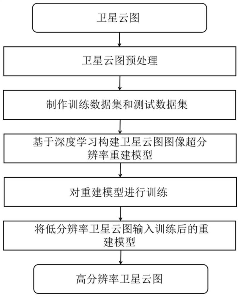
[0053] Such as figure 1 As shown, the present invention provides a method for super-resolution reconstruction of satellite cloud images based on deep learning, which can obtain high-resolution satellite cloud images through low-resolution satellite cloud images, and improve its practicability, including the following steps:

[0054] Step S1: Make and preprocess the satellite cloud image to obtain a high-resolution satellite cloud image dataset;

[0055] In an embodiment, the step S1 includes the following steps:

[0056] Step S101: Making a satellite cloud image based on the high-resolution data of a meteorological satellite:

[0057] Use the albedo data of band 5, band 4, and band 3 in the high-resolution data of Himawari-8 meteorological satellite to make satellite cloud images with natural colors;

[0058] Step S102: Cut the satellite clo...


PUM


Abstract

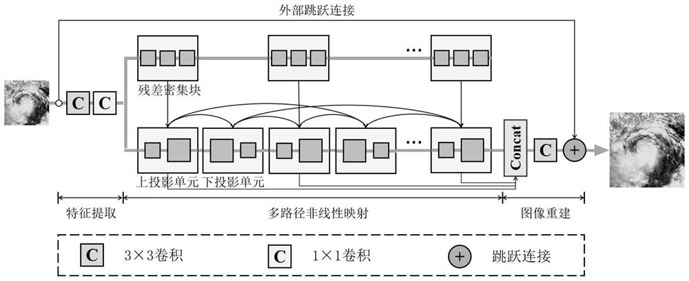
The invention discloses a satellite cloud picture super-resolution reconstruction method based on deep learning, and the method comprises: making and preprocessing a satellite cloud picture, and obtaining a high-resolution satellite cloud picture data set; dividing the high-resolution satellite cloud picture data set into a training data set and a test data set for modeling; constructing and training a satellite cloud picture super-resolution reconstruction model based on deep learning; and inputting the low-resolution satellite cloud picture into the trained satellite cloud picture super-resolution reconstruction model to obtain a high-resolution satellite cloud picture. The high-precision detailed satellite cloud picture high-resolution reconstruction image is obtained through the deep learning method, the reconstruction effect which is more accurate and universal than that of a traditional method is obtained, the high-resolution satellite cloud picture can be obtained through the low-resolution satellite cloud picture, and the practicability of the method is improved.

Description

technical field [0001] The invention belongs to the technical field of super-resolution processing of satellite cloud images, and in particular relates to a super-resolution reconstruction method of satellite cloud images based on deep learning. Background technique [0002] Satellite cloud images are the most widely used meteorological satellite observation products. Satellite cloud images contain information on cloud systems, the atmosphere and the ocean, which is helpful for weather analysis and disaster warning. However, due to the limitations of imaging principles and imaging technologies, the spatial resolution of satellite cloud images cannot meet the needs of meteorological monitoring gradually. [0003] Traditionally, high-resolution satellite data are mainly obtained through higher-precision instrument observations. However, due to the limitations of existing observation technologies, it is difficult for the sensors on satellites to be updated in time. Therefore...

Claims


Application Information

Patent Timeline
Patent Type & Authority Applications(China)
IPC IPC(8): G06T3/40G06T7/11G06N3/04
CPCG06T3/4053G06T7/11G06T2207/10032G06T2207/20081G06N3/045Y02A90/10
Inventor 张敬林杨智鹏刘普薛珂
Owner NANJING UNIV OF INFORMATION SCI & TECH
Learn More