Supercharge Your Innovation With Domain-Expert AI Agents!

Population spatial distribution simulation method and device based on urban inland inundation risk assessment

A technology for risk assessment and urban waterlogging, applied in the field of geographic information systems, can solve the problems of inaccurate and untimely population disaster assessment, and achieve the effect of high timeliness, timely update and completeness

Active Publication Date: 2020-11-03
NANJING UNIV OF POSTS & TELECOMM
View PDF0 Cites 3 Cited by
  • Summary
  • Abstract
  • Description
  • Claims
  • Application Information

AI Technical Summary

Problems solved by technology

[0005] In order to overcome the defects of the prior art, the object of the present invention is to provide a population spatial distribution simulation method and device based on urban waterlogging risk assessment, which solves the problem of the assessment of urban waterlogging risk in the prior art. Factors such as methods and scales lead to the inaccurate and untimely assessment of urban waterlogging risk, especially the assessment of population disasters; taking the assumption that "no buildings, no population" in flood disasters caused by extreme rainstorms, from the perspective of disaster assessment , downscaling urban demographic data, using POI data that has a high correlation with urban population, realizes efficient and accurate population spatial distribution simulation based on urban waterlogging risk assessment at the building scale

Method used


Image

  • Population spatial distribution simulation method and device based on urban inland inundation risk assessment
  • Population spatial distribution simulation method and device based on urban inland inundation risk assessment
  • Population spatial distribution simulation method and device based on urban inland inundation risk assessment

Examples


Embodiment 1

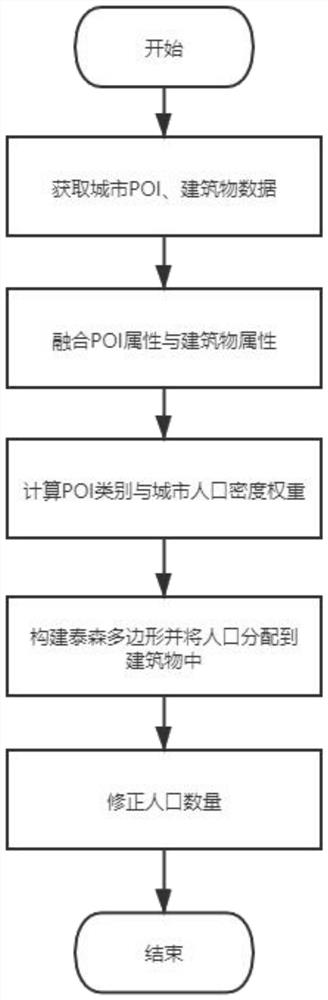
[0053] figure 1 It is a schematic diagram of the process frame structure of a population spatial distribution simulation method based on urban waterlogging risk assessment in a preferred embodiment of the present invention.

[0054] The present invention provides a population spatial distribution simulation method based on urban waterlogging risk assessment, which specifically includes:

[0055] S01: Acquisition and fusion of urban building information;

[0056] S02: Establish the weight relationship between POI data and urban population density;

[0057] S03: Building-oriented population redistribution;

[0058] S04: Population correction.

[0059] Among them, S01 urban building information acquisition and fusion, specifically:

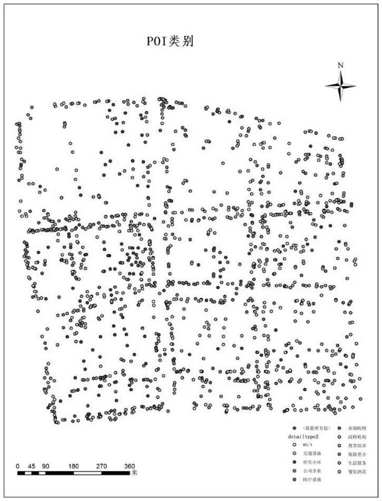
[0060] Acquisition of POI, population grid, and building pattern data: use web crawlers to crawl POI data in the study area; obtain world population grid data from WorldPop official website; obtain building vector data in the study area from Open...

Embodiment 2

[0104] Based on the same inventive concept as the population spatial distribution simulation method based on urban waterlogging risk assessment in the first embodiment, the present invention provides a population spatial distribution simulation device based on urban waterlogging risk assessment, which specifically includes:

[0105] The first unit: used to obtain POI classification and height information of urban buildings, and to fuse building information in the area;

[0106] The second unit: used to establish the weight relationship between POI data and urban population density through the TF-IDF algorithm;

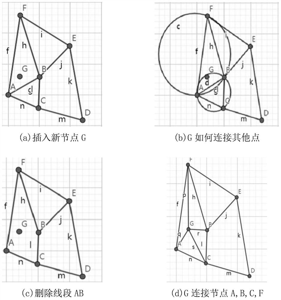
[0107] The third unit: used to construct Thiessen polygons for each category of POI points, superimpose the Thiessen polygons with the population grid, and calculate the population density of each Thiessen polygon according to the weight of the POI category accounting for the population density; use buildings The floor area and height attributes of the building are sup...

Embodiment 3

[0111] Based on the same inventive concept as the method for simulating population spatial distribution based on urban waterlogging risk assessment in the first embodiment, the present invention also provides a computer-readable storage medium on which a computer program is stored, and the program is processed When the device is executed, the steps of the above method are realized.


PUM


Abstract

The invention discloses a population spatial distribution simulation method and device based on urban inland inundation risk assessment. The method specifically comprises the steps that urban buildinginformation is acquired and fused; a weight relationship between the urban POI category and the population density is established; building-oriented population redistribution is carried out; population correction is carried out. Aiming at the conditions that the actual urban inland inundation risk assessment is not accurate and timely, POI data related to the urban population height is adopted tocarry out population space distribution simulation under the building scale, so that the accuracy degree and efficiency of urban affected population assessment in urban inland inundation disasters are improved.

Description

technical field [0001] The invention belongs to the technical field of geographic information systems, and relates to a population spatial distribution simulation method for urban waterlogging risk assessment, which is suitable for the statistics of affected population after urban waterlogging disasters. Background technique [0002] With the intensification of global climate change and the rapid development of urbanization, extreme rainfall occurs frequently, and flood disasters have increasingly become the main natural disasters faced by major cities in my country. Population is the most important disaster-affected body in flood disasters. Accurate spatial-temporal distribution information of population is an important basis for urban calculation. [0003] In the traditional urban population calculation process that uses administrative divisions as the statistical unit, on the one hand, the scale of the demographic unit is too large to meet the calculation of urban functio...

Claims


Application Information

Patent Timeline
Patent Type & Authority Applications(China)
IPC IPC(8): G06F30/20G06Q10/06
CPCG06F30/20G06Q10/0635Y02A90/10
Inventor 李猛张海涛朱少楠邵家琦
Owner NANJING UNIV OF POSTS & TELECOMM
Features
  • R&D
  • Intellectual Property
  • Life Sciences
  • Materials
  • Tech Scout
  • Unparalleled Data Quality
  • Higher Quality Content
  • 60% Fewer Hallucinations
Learn More