Eureka AIR delivers breakthrough ideas for toughest innovation challenges, trusted by R&D personnel around the world.

Ground target reality sense simulation method in remote sensing scene

A technology of ground targets and simulation methods, applied in image data processing, instruments, character and pattern recognition, etc., can solve problems such as complex 3D modeling and insufficient 2D spatial texture information

Active Publication Date: 2020-12-01
XI'AN INST OF OPTICS & FINE MECHANICS - CHINESE ACAD OF SCI
View PDF4 Cites 0 Cited by
  • Summary
  • Abstract
  • Description
  • Claims
  • Application Information

AI Technical Summary

Problems solved by technology

[0004] The present invention proposes a realistic simulation method for ground targets in a remote sensing scene, which solves the problem of insufficient two-dimensional spatial texture information and the complexity of three-dimensional modeling in the remote sensing ground space simulation stage of the existing remote sensing data simulation

Method used


Image

  • Ground target reality sense simulation method in remote sensing scene
  • Ground target reality sense simulation method in remote sensing scene
  • Ground target reality sense simulation method in remote sensing scene

Examples


Embodiment Construction

[0091] The technical solutions of the present invention will be clearly and completely described below in conjunction with the implementation examples of the invention and the accompanying drawings. Apparently, the described implementation examples do not limit the present invention.

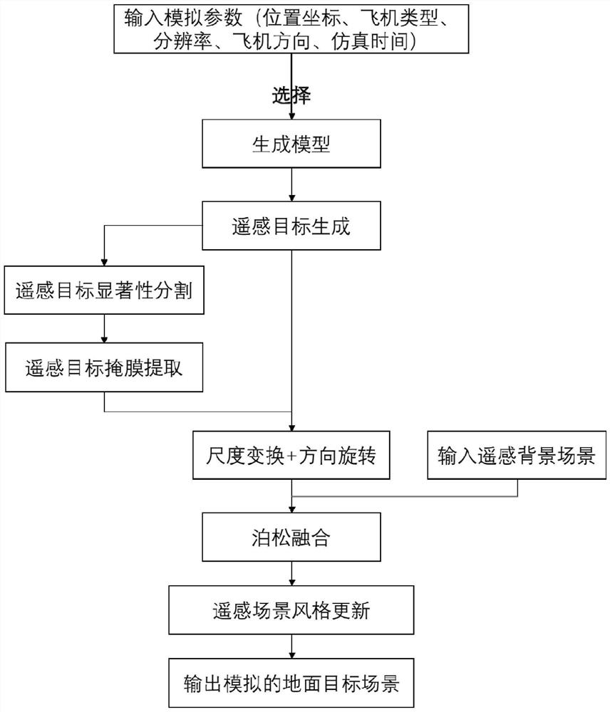
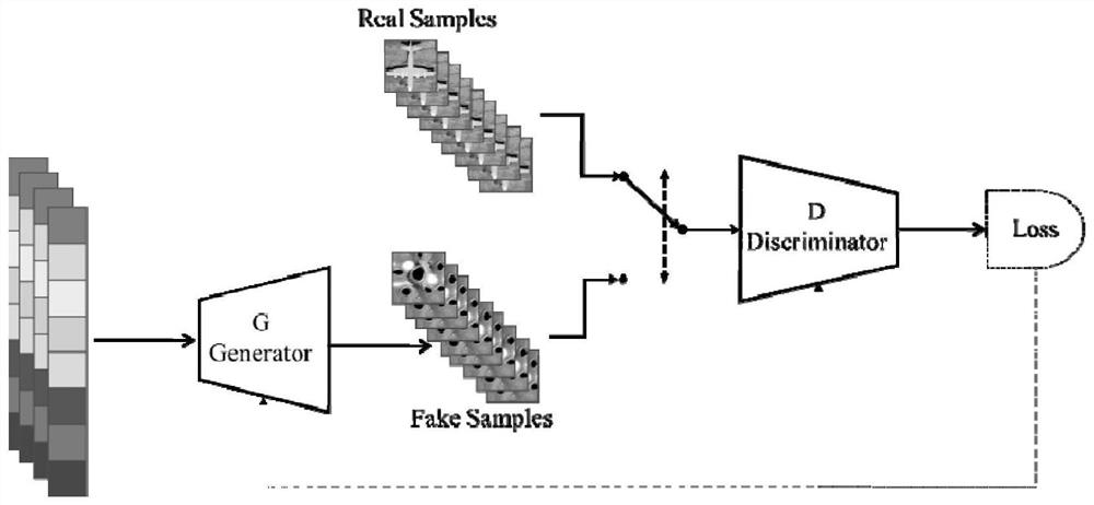
[0092] The present invention proposes a real-sense simulation method for ground targets in a remote sensing scene. For the first time, the method proposes a realistic simulation method for self-adaptive simulation of ground remote-sensing targets. Only a few sets of simple demand parameters need to be input to obtain real ground targets. Simultaneously, the generation model based on the self-attention mechanism and the residual network is used to simulate the probability distribution of the remote sensing target, which enhances the remote sensing target data, improves the realism of the ground remote sensing target simulation, and satisfies human The flexibility and convenience of computer intera...


PUM


Abstract

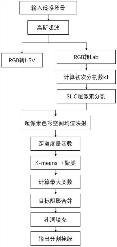
The invention provides a ground target reality sense simulation method in a remote sensing scene, and solves the problems of insufficient two-dimensional space texture information and complexity of three-dimensional modeling of existing remote sensing data simulation in a remote sensing ground space simulation stage. The method comprises the following steps: 1) inputting simulation parameters; 2)selecting a target generation network; 3) adaptively generating a scene target according to the selected generation model; 4) performing significance segmentation on the generated remote sensing target, and extracting a corresponding mask; 5) performing scale transformation and direction rotation on the generated remote sensing target and the extracted mask according to the input parameters; 6) performing Poisson fusion on the remote sensing target and the target mask in the step 5) in combination with a remote sensing background scene, 7) performing climate feature mapping according to inputtime and climate parameters, and 8) outputting a simulation result of a virtual target in a final real scene.

Description

technical field [0001] The invention belongs to the field of quantitative simulation of remote sensing data, and in particular relates to a realistic simulation method of a ground target in a remote sensing scene, which is used for conducting simulation research on a remote sensing target in a remote sensing scene. Background technique [0002] Before the remote sensor is developed and put into use, it is necessary to carry out a complete and systematic understanding of the load index of the developed remote sensor. In order to minimize the cost and risk of payload launch, a simulation system is usually built to simulate relevant data during the development stage of remote sensors. Therefore, it has become a consensus to understand the data load characteristics through the simulation analysis of the scene target. The Institute of Remote Sensing Applications of the Chinese Academy of Sciences and the Jia Guorui team of the School of Instrument Science and Optoelectronic Engi...

Claims


Application Information

Patent Timeline
IPC IPC(8): G06T7/00G06T7/11G06T7/136G06T7/194G06T7/90G06T5/50G06K9/62
CPCG06T7/0002G06T7/11G06T7/136G06T7/194G06T7/90G06T5/50G06T2207/10032G06T2207/20081G06T2207/20084G06T2207/30181G06T2207/20221G06F18/23213Y02A90/10
Inventor 李海巍陈军宇张耿陈铁桥王爽胡炳樑
Owner XI'AN INST OF OPTICS & FINE MECHANICS - CHINESE ACAD OF SCI
Why Eureka
Eureka Blog
Learn More