Earthwork optimization method and system based on three-dimensional oblique photography technology

A technology of oblique photography and optimization method, which is applied in the direction of design optimization/simulation, image data processing, special data processing applications, etc. It can solve the problems of data collection distortion, difficulty in ensuring data collection accuracy, large height difference, etc., and achieve earthwork volume precise effect

Pending Publication Date: 2020-12-18
CHINA CONSTR EIGHT ENG DIV CORP LTD
View PDF0 Cites 6 Cited by
  • Summary
  • Abstract
  • Description
  • Claims
  • Application Information

AI Technical Summary

Problems solved by technology

[0006] The calculation accuracy of traditional measurement methods is related to the density, quality and grid size of field sampling points. Especially for steep terrain, data collection is more difficult, and it is difficult to ensure the accuracy of data collection. In areas with large height differences and many buildings, RTK cannot achieve a fixed solution, and the collected data is distorted

Method used


Image

  • Earthwork optimization method and system based on three-dimensional oblique photography technology
  • Earthwork optimization method and system based on three-dimensional oblique photography technology
  • Earthwork optimization method and system based on three-dimensional oblique photography technology

Examples


Embodiment

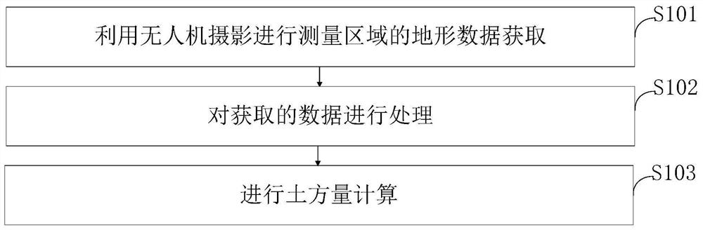
[0090] (1) Collection

[0091] 1. UAV photogrammetry terrain collection

[0092] 1.1 Determine the scope of the survey area

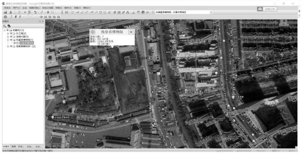
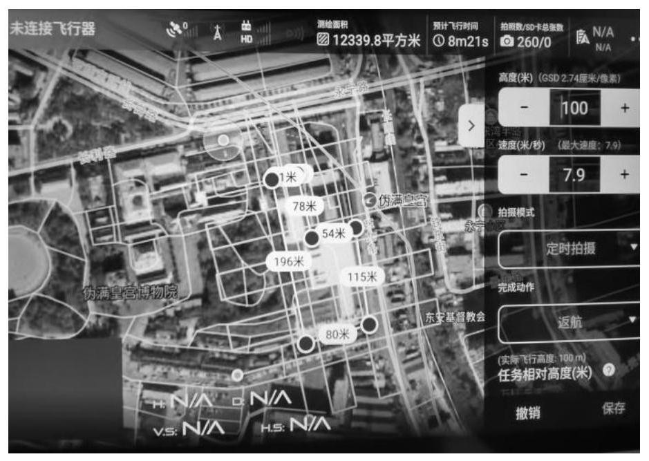
[0093] This survey field project chooses the exhibition hall project of the Pseudo-Imperial Palace Museum, and uses the DJI Phantom IV RTK UAV platform for image-free flight. For detection accuracy, South Galaxy VI RTK is used to arrange image control points and inspection points on site, and Context Capture is used Carry out image data processing, use EPS to extract elevation points, and form terrain surface data. Use the Aowei map browser, cooperate with the Google satellite mixed topographic map, accurately determine the scope of the area, redraw the survey area into a surface shape, export it as a KML file, and use it as a route planning area, such as figure 2 shown.

[0094] 1.2. Precise flight

[0095] 1.2.1 Arrangement of image control points

[0096] Image control points are the basis of photogrammetry control encryption and mapping. The q...


PUM


Abstract

The invention belongs to the technical field of civil engineering, and discloses an earthwork optimization method and system based on a three-dimensional oblique photography technology. The method comprises the following steps: acquiring topographic data of the measurement area by using unmanned aerial vehicle photography; processing the acquired data; performing earth volume calculation. According to the method disclosed in the invention, a traditional single-point measurement mode is pushed to a surface measurement mode, and large-area acquisition of point cloud data of a target surface is realized; comprehensive improvement in the aspects of data acquisition efficiency, data acquisition range, data precision, and safety and automation of measurement operation is realized. a three-dimensional entity is generated by combining the powerful curved surface processing function of Civil3D in the BIM and adopting a terrain superposition principle, and the volume of the soil body is calculated. According to the method disclosed in the invention, the point cloud data of the target surface can be acquired in a large area; the data acquisition efficiency, the data acquisition range, the data precision, and the safety and automation of measurement operation are comprehensively improved.

Description

technical field [0001] The invention belongs to the technical field of civil engineering, and in particular relates to an earthwork optimization method and system based on three-dimensional oblique photography technology. Background technique [0002] At present, in the cost and budget of construction projects, the amount of earth and stone is an extremely important indicator. The traditional earthwork calculation method mainly uses RTK for data collection and grid calculation. For large-area and large-volume earthwork with complex terrain, the efficiency and accuracy of calculation are relatively low. A lot of research has been done on earthwork calculation methods at home and abroad. Existing technology 1 has carried out secondary development of earthwork calculation software system based on AutoCAD platform; The generation of triangular nets has been studied; prior art 3 proposes a DEM-based earth-rock calculation method based on the two-dimensional graphics and three-di...

Claims


Application Information

Patent Timeline
Patent Type & Authority Applications(China)
IPC IPC(8): G06F30/13G06F30/20G06T17/05G06T17/30
CPCG06T17/05G06T17/30G06F30/13G06F30/20
Inventor 张学伟袁俭任维峰郭玉峰刘成徐亮杨晶荣斌李钊
Owner CHINA CONSTR EIGHT ENG DIV CORP LTD
Why Eureka
Try Eureka