Reference plane adjustment and obstacle detection methods, depth camera and navigation equipment

A technology of reference plane and adjustment method, applied in the field of distance sensing, can solve problems such as inaccurate detection of ground obstacles, and achieve the effect of easy implementation, simple algorithm and improved accuracy

Active Publication Date: 2021-01-08
SHANGHAI JUYOU SMART INTELLIGENCE TECH CO LTD
View PDF9 Cites 1 Cited by
  • Summary
  • Abstract
  • Description
  • Claims
  • Application Information

AI Technical Summary

Problems solved by technology

[0005] In view of this, this application provides a reference plane adjustment method, an obstacle detection method, a depth camera and ground navigation equipment to solve the problems caused by differences in the ground environment in the prior art The problem of inaccurate detection of ground obstacles caused by

Method used


Image

  • Reference plane adjustment and obstacle detection methods, depth camera and navigation equipment
  • Reference plane adjustment and obstacle detection methods, depth camera and navigation equipment
  • Reference plane adjustment and obstacle detection methods, depth camera and navigation equipment

Examples


Embodiment Construction

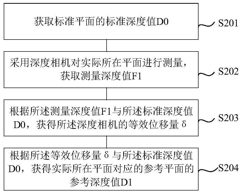
[0038] As mentioned in the background technology, in the prior art, due to the complexity of the ground material and the ground scene, it is difficult to develop the corresponding ground identification algorithm, especially near the ground, the reflectivity distribution is more complicated, and there are significant Factors such as multi-path reflection will bring large errors to the depth measurement of the depth camera, especially for TOF cameras that measure distance by the time-of-flight difference between the detected light and the reflected light, it will bring more significant measurement errors , so that the ground position cannot be accurately identified, and then the height measurement of obstacles will be biased.

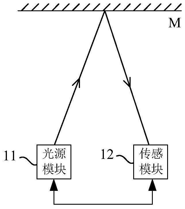
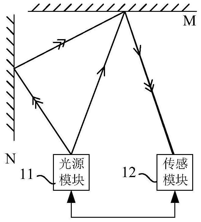
[0039] Please refer to Figure 1a and Figure 1b , is a structural schematic diagram of the TOF camera.

[0040] The ToF camera includes a light source module 11 and a sensing module 12. The light source module 11 is used to emit detection light to the o...


PUM


Abstract

The invention discloses a reference plane adjustment method, an obstacle detection method, a depth camera and ground navigation equipment. The reference plane adjustment method comprises the followingsteps of: acquiring a standard depth value D0 of a standard plane; adopting a depth camera to measure an actual plane to obtain a measured depth value F1; obtaining an equivalent displacement delta of the depth camera according to the measured depth value F1 and the standard depth value D0, the equivalent displacement delta being an equivalent displacement distance of the plane where the depth camera is actually located relative to the standard plane; and obtaining a reference depth value D1 of a reference plane corresponding to the actual plane according to the equivalent displacement deltaand the standard depth value D0. According to the method, a more accurate reference plane can be obtained based on environmental interference of an actual detection scene.

Description

technical field [0001] The present application relates to the technical field of distance sensing, in particular to a reference plane adjustment and obstacle detection method, a depth camera, and ground navigation equipment. Background technique [0002] Time of flight (ToF, Time of Flight) camera realizes the measurement of the distance, three-dimensional structure or three-dimensional profile of the measured object through the time interval of the pulse signal sent by the sensor from transmission to reception or the phase generated by the laser going back and forth to the measured object once. . ToF sensors can simultaneously obtain grayscale images and distance images, and are widely used in many fields such as somatosensory control, behavior analysis, monitoring, automatic driving, artificial intelligence, machine vision, and automatic 3D modeling. [0003] ToF cameras are widely used in the field of AGV (Automated Guided Vehicle) ground navigation, such as in sweeping ...

Claims


Application Information

Patent Timeline
Patent Type & Authority Applications(China)
IPC IPC(8): G01S17/894G01S17/48G06T7/521
CPCG01S17/894G01S17/48G06T7/521G06T2207/10004
Inventor 胡洪伟梅健
Owner SHANGHAI JUYOU SMART INTELLIGENCE TECH CO LTD
Why Eureka
Try Eureka