Land expropriation immigrant land area automatic measuring and calculating method

A technology for land area and measurement, applied in the field of land area measurement for land acquisition and resettlement, can solve problems such as ineffective facets, high error rates, gaps between lines and lines, etc., to improve the accuracy of measurement, high automation, and operation. simple effect

Pending Publication Date: 2021-01-08
GUIZHOU SURVEY & DESIGN RES INST FOR WATER RESOURCES & HYDROPOWER
View PDF0 Cites 2 Cited by
  • Summary
  • Abstract
  • Description
  • Claims
  • Application Information

AI Technical Summary

Problems solved by technology

[0003] In order to complete the measurement and statistics of land requisition indicators, the general operation mode is to use field survey data to draw land topographic maps in the computer, and based on the topographic map of land types, block by block, measure the area, and transcribe it into an EXCEL form. Such as Southern CASS software, this method needs to measure the area of ​​each map spot, the measurement results cannot be directly converted into EXECL results, the efficiency is very low, and the error rate is high
At present, many scholars have proposed to realize the automatic calculation function based on GIS technology, and convert the results into EXCEL tables, such as ArcGIS or MapGIS and other software. This method improves the work efficiency and avoids errors caused by manual transcription of data. However, , because this method is implemented automatically in batches, and lacks artificial proofreading one by one, it will bring the following problems: First, because the drawing is not standardized, there are gaps between some lines and lines, and the face cannot be effectively structured, which will lead to the fusion of two patches. For a block, the result is not correct; secondly, the attribute connection is realized through the point-plane overlay operation, and the attribute is often in the form of text. The figure may be displayed in the correct map, but the anchor point may be in other maps. There will be attribute association errors, resulting in incorrect attributes such as head of household and land type

Method used


Image

  • Land expropriation immigrant land area automatic measuring and calculating method
  • Land expropriation immigrant land area automatic measuring and calculating method
  • Land expropriation immigrant land area automatic measuring and calculating method

Examples


Embodiment 1

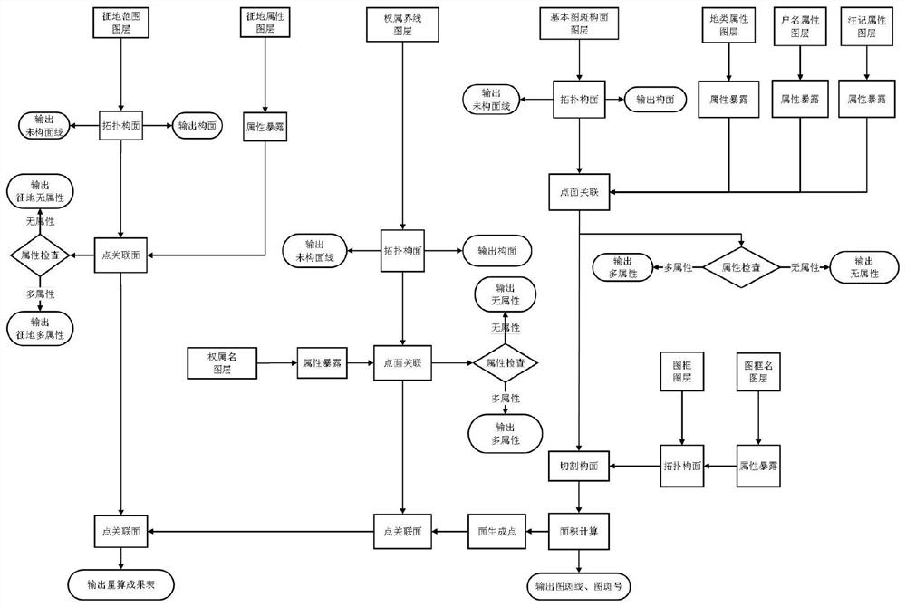
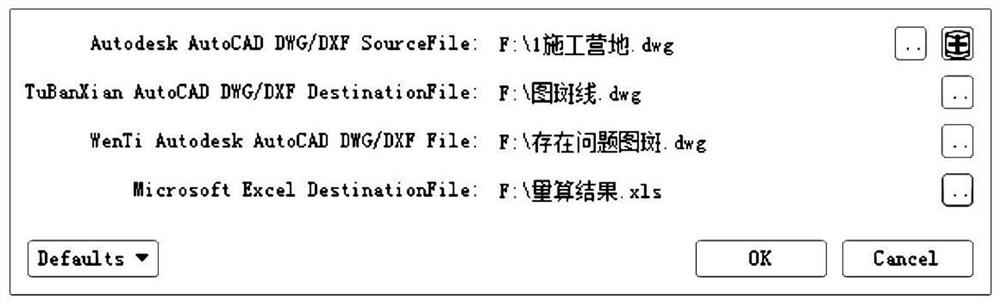
[0031] Embodiment 1: A method for automatically measuring and calculating the land area of ​​land expropriation and resettlement, integrating steps 101-104 into a desktop application program, the user only needs to input the topographic map file of the source land and the output file for storing the measurement results, this implementation The example is realized by fme software, the desktop system interface is shown in the appendix figure 2 , see the attached flow chart figure 1 , the specific method steps are as follows:

[0032] Step: 101: Construct surface elements and output line elements that do not participate in the facet based on the layered topology of the land type topographic map data;

[0033] Step 102: Perform attribute association and logical error map output on the constructed elements at each level;

[0034] Step 103: Perform attribute association between the speckled surface elements of the basic map and other advanced surface elements to obtain complete a...


PUM


Abstract

The invention discloses a land expropriation immigrant land area automatic measurement and calculation method, which realizes area automatic measurement and calculation and output by utilizing topology and space analysis technologies, and comprises the following steps: constructing surface elements and outputting line elements which do not participate in a tectonic plane based on land topographicmap data hierarchical topology; carrying out attribute association and logic error pattern spot output on each constructed layer element; carrying out attribute association on the basic pattern spot surface elements and other advanced surface elements to obtain complete attributes; and calculating the area by utilizing the basic pattern spot surface elements, creating a pattern spot number, and outputting a result. The method is highly integrated and simple to operate, and does not need deep professional knowledge. The method is high in automation degree, can quickly measure and calculate results, and is very high in efficiency. In addition, the method provides a map belonging debugging mechanism, finally ensures that a measurement result is consistent with a map surface through graph debugging and attribute debugging, and improves the measurement accuracy of land indexes of immigrant land expropriation.

Description

technical field [0001] The invention relates to the technical field of land area measurement and calculation for land acquisition and resettlement, in particular to an automatic calculation method for land area of ​​land acquisition and resettlement. Background technique [0002] Project construction often involves land acquisition, which involves land compensation. Clarifying indicators such as land ownership, land type, and area is the main content of land acquisition and resettlement work. In actual work, the measurement and statistics of land indicators is a very cumbersome task. It needs to draw a closed line, measure the area, and mark the number of the map one by one. Then, the area, land type, Ownership, map number information, etc. are transcribed one by one in the electronic form, and finally counted according to various requirements. It is not difficult for small-scale land acquisition, and the efficiency and accuracy can be guaranteed. However, if it involves la...

Claims


Application Information

Patent Timeline
Patent Type & Authority Applications(China)
IPC IPC(8): G06T7/62G06T17/05G06F16/29
CPCG06T17/05G06T7/62G06F16/29
Inventor 王陆军徐锐罗天文吴恒友杨文联王敏王超刘怀林
Owner GUIZHOU SURVEY & DESIGN RES INST FOR WATER RESOURCES & HYDROPOWER
Why Eureka
Try Eureka