Data interpretation and recognition method for three-dimensional ground penetrating radar

A ground-penetrating radar and recognition method technology, applied in the field of ground-penetrating radar, can solve problems such as low execution efficiency, deviation of processing results, and inability to work continuously

Active Publication Date: 2021-01-15
深圳安德空间技术有限公司
View PDF10 Cites 8 Cited by
  • Summary
  • Abstract
  • Description
  • Claims
  • Application Information

AI Technical Summary

Problems solved by technology

At present, the data processing and image interpretation of 3D ground penetrating radar are mainly carried out manually, which has low execution efficiency and cannot work continuously
Inconsistent standards of different processing personnel lead to deviations in processing results

Method used


Image

  • Data interpretation and recognition method for three-dimensional ground penetrating radar
  • Data interpretation and recognition method for three-dimensional ground penetrating radar
  • Data interpretation and recognition method for three-dimensional ground penetrating radar

Examples


Embodiment Construction

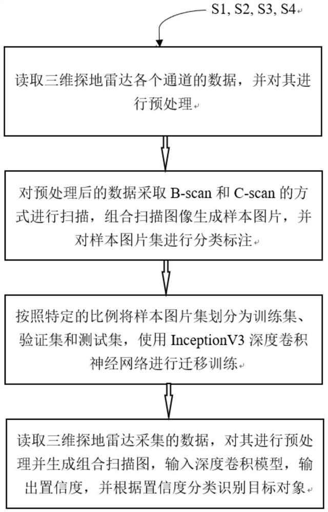
[0072] refer to figure 1 , the present invention provides a technical solution:

[0073] A data interpretation and recognition method for a three-dimensional ground penetrating radar, comprising steps S1 to S4.

[0074] In step S1, read the data of each channel of the three-dimensional ground penetrating radar, and preprocess it;

[0075] During implementation, the preferred step S1 of this program further includes stage 1 and stage 2:

[0076] In stage 1, the raw radar data of all 16 channels in all survey lines are read and converted to the image domain, and the conversion formula is:

[0077]

[0078] where x i is the original ith echo value, f(x i ) is the filter function, y i is the corresponding value converted to the image domain whose gray value range is [0,b].

[0079] Through the above conversion, the normalization process of radar data amplitude components to image pixels is completed.

[0080] In stage 2, gain and filter preprocessing are performed on the...


PUM


Abstract

The invention relates to the technical field of ground penetrating radars, in particular to a data interpretation and recognition method for a three-dimensional ground penetrating radar. The method adopts artificial intelligence based on deep learning to interpret and identify three-dimensional ground penetrating radar data, and comprises the following steps: reading data of each channel of a three-dimensional ground penetrating radar, and preprocessing the data; scanning the preprocessed data in a Bscan and Cscan mode, combining the scanned images to generate sample pictures, and performing classification annotation on a sample picture set; dividing the sample picture set into a training set, a verification set and a test set according to a specific proportion, and performing migration training by using an InceptionV3 deep convolutional neural network; reading data acquired by the three-dimensional ground penetrating radar, preprocessing the data, generating a combined scanning image,inputting the combined scanning image into a deep convolution model hdf5 format file, outputting confidence, and classifying and identifying a target object according to the confidence.

Description

technical field [0001] The invention relates to the technical field of ground penetrating radar, in particular to a data interpretation and identification method for three-dimensional ground penetrating radar. Background technique [0002] Ground Penetrating Radar (Ground Penetrating Radar), also known as geological radar, detects underground media by emitting high-frequency pulsed electromagnetic waves (frequency between 1MHz-1GHz), and determines the distribution of underground media. It has simple operation, high detection accuracy, no damage, and acquisition It is the most active detection technology for engineering inspection and survey at present, and it is widely used in the detection of underground diseases of urban roads. Compared with the traditional two-dimensional radar with only one longitudinal and vertical profile waveform, the three-dimensional radar seamlessly splices radar data and position information through real-time rapid sampling, collects horizontal p...

Claims


Application Information

Patent Timeline
Patent Type & Authority Applications(China)
IPC IPC(8): G06K9/62G01S13/88G06N3/04G06N3/08
CPCG01S13/885G06N3/08G06N3/045G06F18/24
Inventor 项芒
Owner 深圳安德空间技术有限公司
Why Eureka
Try Eureka